![](/images/other/stat-length.png)
- Randonnées
- A pied
- Italie
- Trentin-Haut-Adige
- Provincia di Trento
Provincia di Trento, Trentin-Haut-Adige, A pied : Les meilleures randonnées, itinéraires, parcours, balades et promenades
Provincia di Trento : découvrez les meilleures randonnées : 735 a pied et 90 marche. Tous ces circuits, parcours, itinéraires et activités en plein air sont disponibles dans nos applications SityTrail pour smartphones et tablettes.
Les meilleurs parcours (825)
![Randonnée A pied Vignola Falesina - Percorso Natura - Photo](https://media.geolcdn.com/t/350/260/32f38aae-1dca-4b56-aef8-8193d4311dbb.jpeg&format=jpg&maxdim=2)
![A pied A pied](https://static1.geolcdn.com/sitytour/trail-icons/100.png)
Km
A pied
![](/images/other/stat-length.png)
![](https://static1.geolcdn.com/siteimages/upload/files/1508320355ic_sort_den_pos_24dp.png)
![](https://static1.geolcdn.com/siteimages/upload/files/1508320355ic_sort_den_neg_24dp.png)
![](https://static1.geolcdn.com/siteimages/upload/files/16400158638029165_repeat_loop_refresh_sync_direction_icon.png)
• Randonnée créée par Associazione Filò.
![Randonnée A pied Ville di Fiemme - (SI C14N) Passo Lavaze - Obereggen - Photo](https://media.geolcdn.com/t/350/260/b2fa3ea8-941c-4df4-804d-fbf84e9ebdb3.jpeg&format=jpg&maxdim=2)
![A pied A pied](https://static1.geolcdn.com/sitytour/trail-icons/100.png)
Km
A pied
![](/images/other/stat-length.png)
![](https://static1.geolcdn.com/siteimages/upload/files/1508320355ic_sort_den_pos_24dp.png)
![](https://static1.geolcdn.com/siteimages/upload/files/1508320355ic_sort_den_neg_24dp.png)
![](https://static1.geolcdn.com/siteimages/upload/files/16400158638029165_repeat_loop_refresh_sync_direction_icon.png)
• Snetiero Italia CAI 2020
![Randonnée A pied Capriana - (SI C12N) Malga Parco Corno - Redagno di Sopra - Photo](https://media.geolcdn.com/t/350/260/c1e1c650-cf5c-4a36-9780-1c5a6fa19e3f.jpeg&format=jpg&maxdim=2)
![A pied A pied](https://static1.geolcdn.com/sitytour/trail-icons/100.png)
Km
A pied
![](/images/other/stat-length.png)
![](https://static1.geolcdn.com/siteimages/upload/files/1508320355ic_sort_den_pos_24dp.png)
![](https://static1.geolcdn.com/siteimages/upload/files/1508320355ic_sort_den_neg_24dp.png)
![](https://static1.geolcdn.com/siteimages/upload/files/16400158638029165_repeat_loop_refresh_sync_direction_icon.png)
• Sentiero Italia CAI 2019
![Randonnée A pied Ziano di Fiemme - TransLagorai - Photo](https://media.geolcdn.com/t/350/260/1a61f460-8146-4a36-a8e2-66886ea56ed4.jpeg&format=jpg&maxdim=2)
![A pied A pied](https://static1.geolcdn.com/sitytour/trail-icons/100.png)
Km
A pied
![](/images/other/stat-length.png)
![](https://static1.geolcdn.com/siteimages/upload/files/1508320355ic_sort_den_pos_24dp.png)
![](https://static1.geolcdn.com/siteimages/upload/files/1508320355ic_sort_den_neg_24dp.png)
![](https://static1.geolcdn.com/siteimages/upload/files/16400158638029165_repeat_loop_refresh_sync_direction_icon.png)
• Site web: https://www.magicoveneto.it/Lagorai/trek/TransLagorai.htm
![Randonnée A pied Scurelle - (SI C13S) Rifugio Malga Conseria - Forccella Magna - Passo dei Pastori - Rifugio Brentari alla Cima d'Asta - Forcella di Val Regana - Caoria - Photo](https://media.geolcdn.com/t/350/260/39df84f1-b6c4-40a0-a378-19e5939e6072.jpeg&format=jpg&maxdim=2)
![A pied A pied](https://static1.geolcdn.com/sitytour/trail-icons/100.png)
Km
A pied
![](/images/other/stat-length.png)
![](https://static1.geolcdn.com/siteimages/upload/files/1508320355ic_sort_den_pos_24dp.png)
![](https://static1.geolcdn.com/siteimages/upload/files/1508320355ic_sort_den_neg_24dp.png)
![](https://static1.geolcdn.com/siteimages/upload/files/16400158638029165_repeat_loop_refresh_sync_direction_icon.png)
• Sentiero Italia CAI 2019
![Randonnée A pied Altavalle - (SI C11N) Potzmauer - Malga Parco Corno - Photo](https://media.geolcdn.com/t/350/260/7d6d622b-3f92-4109-a836-34b65d7c4ea5.jpeg&format=jpg&maxdim=2)
![A pied A pied](https://static1.geolcdn.com/sitytour/trail-icons/100.png)
Km
A pied
![](/images/other/stat-length.png)
![](https://static1.geolcdn.com/siteimages/upload/files/1508320355ic_sort_den_pos_24dp.png)
![](https://static1.geolcdn.com/siteimages/upload/files/1508320355ic_sort_den_neg_24dp.png)
![](https://static1.geolcdn.com/siteimages/upload/files/16400158638029165_repeat_loop_refresh_sync_direction_icon.png)
• Sentiero Italia CAI 2019
![Randonnée A pied Scurelle - Sentiero Augusto Daolio Dante Pergreffi - Photo](https://media.geolcdn.com/t/350/260/962c96c9-5e71-4583-a19c-3e6918d0fba1.jpeg&format=jpg&maxdim=2)
![A pied A pied](https://static1.geolcdn.com/sitytour/trail-icons/100.png)
Km
A pied
![](/images/other/stat-length.png)
![](https://static1.geolcdn.com/siteimages/upload/files/1508320355ic_sort_den_pos_24dp.png)
![](https://static1.geolcdn.com/siteimages/upload/files/1508320355ic_sort_den_neg_24dp.png)
![](https://static1.geolcdn.com/siteimages/upload/files/16400158638029165_repeat_loop_refresh_sync_direction_icon.png)
• Randonnée créée par Comune di Scurelle. Symbole: L31 on white red flags
![Randonnée A pied Terragnolo - Il Sentiero delle](https://media.geolcdn.com/t/350/260/179ffb1b-b500-4274-b0bc-52d9df13f95d.jpeg&format=jpg&maxdim=2)
![A pied A pied](https://static1.geolcdn.com/sitytour/trail-icons/100.png)
Km
A pied
![](/images/other/stat-length.png)
![](https://static1.geolcdn.com/siteimages/upload/files/1508320355ic_sort_den_pos_24dp.png)
![](https://static1.geolcdn.com/siteimages/upload/files/1508320355ic_sort_den_neg_24dp.png)
![](https://static1.geolcdn.com/siteimages/upload/files/16400158638029165_repeat_loop_refresh_sync_direction_icon.png)
• Site web: http://www.sentieroteragnole.it/
![Randonnée A pied Avio - Sentiero Bovi - Photo](https://media.geolcdn.com/t/350/260/4702fb67-6073-457f-bd90-e77faeb3b6e8.jpeg&format=jpg&maxdim=2)
![A pied A pied](https://static1.geolcdn.com/sitytour/trail-icons/100.png)
Km
A pied
![](/images/other/stat-length.png)
![](https://static1.geolcdn.com/siteimages/upload/files/1508320355ic_sort_den_pos_24dp.png)
![](https://static1.geolcdn.com/siteimages/upload/files/1508320355ic_sort_den_neg_24dp.png)
![](https://static1.geolcdn.com/siteimages/upload/files/16400158638029165_repeat_loop_refresh_sync_direction_icon.png)
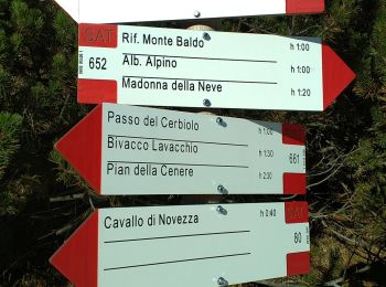
• Randonnée créée par Club Alpino Italiano Sezione di Verona. Symbole: 652 on white red flag
![Randonnée A pied Primiero San Martino di Castrozza - IT-751 - Photo](https://media.geolcdn.com/t/350/260/84125359-dad4-4994-a82a-7c7aa611646c.jpeg&format=jpg&maxdim=2)
![A pied A pied](https://static1.geolcdn.com/sitytour/trail-icons/100.png)
Km
A pied
![](/images/other/stat-length.png)
![](https://static1.geolcdn.com/siteimages/upload/files/1508320355ic_sort_den_pos_24dp.png)
![](https://static1.geolcdn.com/siteimages/upload/files/1508320355ic_sort_den_neg_24dp.png)
![](https://static1.geolcdn.com/siteimages/upload/files/16400158638029165_repeat_loop_refresh_sync_direction_icon.png)
• Randonnée créée par CAI Agordo.
![Randonnée A pied Trente - IT-E447 - Photo](https://media.geolcdn.com/t/350/260/d296c774-fa9e-44ba-8c01-77b3bbd15bf0.jpeg&format=jpg&maxdim=2)
![A pied A pied](https://static1.geolcdn.com/sitytour/trail-icons/100.png)
Km
A pied
![](/images/other/stat-length.png)
![](https://static1.geolcdn.com/siteimages/upload/files/1508320355ic_sort_den_pos_24dp.png)
![](https://static1.geolcdn.com/siteimages/upload/files/1508320355ic_sort_den_neg_24dp.png)
![](https://static1.geolcdn.com/siteimages/upload/files/16400158638029165_repeat_loop_refresh_sync_direction_icon.png)
• Randonnée créée par Società degli Alpinisti Tridentini. Site web: http://www.sat.tn.it/
![Randonnée A pied Brentonico - IT-O654 - Photo](https://media.geolcdn.com/t/350/260/471fd94c-bd42-437a-9cd8-0693f7690595.jpeg&format=jpg&maxdim=2)
![A pied A pied](https://static1.geolcdn.com/sitytour/trail-icons/100.png)
Km
A pied
![](/images/other/stat-length.png)
![](https://static1.geolcdn.com/siteimages/upload/files/1508320355ic_sort_den_pos_24dp.png)
![](https://static1.geolcdn.com/siteimages/upload/files/1508320355ic_sort_den_neg_24dp.png)
![](https://static1.geolcdn.com/siteimages/upload/files/16400158638029165_repeat_loop_refresh_sync_direction_icon.png)
• Randonnée créée par Società degli Alpinisti Tridentini. Site web: http://www.sat.tn.it/
![Randonnée A pied Avio - IT-O652 - Photo](https://media.geolcdn.com/t/350/260/5e7c333d-5ccf-463b-9f3f-4867284d4645.jpeg&format=jpg&maxdim=2)
![A pied A pied](https://static1.geolcdn.com/sitytour/trail-icons/100.png)
Km
A pied
![](/images/other/stat-length.png)
![](https://static1.geolcdn.com/siteimages/upload/files/1508320355ic_sort_den_pos_24dp.png)
![](https://static1.geolcdn.com/siteimages/upload/files/1508320355ic_sort_den_neg_24dp.png)
![](https://static1.geolcdn.com/siteimages/upload/files/16400158638029165_repeat_loop_refresh_sync_direction_icon.png)
• Randonnée créée par Società degli Alpinisti Tridentini. Site web: http://www.sat.tn.it/
![Randonnée A pied Brentonico - IT-O651 - Photo](https://media.geolcdn.com/t/350/260/6911bd7a-2777-48f7-ba85-a30fc036b9ed.jpeg&format=jpg&maxdim=2)
![A pied A pied](https://static1.geolcdn.com/sitytour/trail-icons/100.png)
Km
A pied
![](/images/other/stat-length.png)
![](https://static1.geolcdn.com/siteimages/upload/files/1508320355ic_sort_den_pos_24dp.png)
![](https://static1.geolcdn.com/siteimages/upload/files/1508320355ic_sort_den_neg_24dp.png)
![](https://static1.geolcdn.com/siteimages/upload/files/16400158638029165_repeat_loop_refresh_sync_direction_icon.png)
• Randonnée créée par Società degli Alpinisti Tridentini. Site web: http://www.sat.tn.it/
![Randonnée A pied Molveno - Senter de la Mars - Photo](https://media.geolcdn.com/t/350/260/73a3f382-f1e1-4c06-92a6-bda5359b56f6.jpeg&format=jpg&maxdim=2)
![A pied A pied](https://static1.geolcdn.com/sitytour/trail-icons/100.png)
Km
A pied
![](/images/other/stat-length.png)
![](https://static1.geolcdn.com/siteimages/upload/files/1508320355ic_sort_den_pos_24dp.png)
![](https://static1.geolcdn.com/siteimages/upload/files/1508320355ic_sort_den_neg_24dp.png)
![](https://static1.geolcdn.com/siteimages/upload/files/16400158638029165_repeat_loop_refresh_sync_direction_icon.png)
• Randonnée créée par Società degli Alpinisti Tridentini. Site web: http://www.sat.tn.it/
![Randonnée A pied Vallelaghi - IT-O643 - Photo](https://media.geolcdn.com/t/350/260/6da6a6d3-c1d0-4573-a925-996af0c455a0.jpeg&format=jpg&maxdim=2)
![A pied A pied](https://static1.geolcdn.com/sitytour/trail-icons/100.png)
Km
A pied
![](/images/other/stat-length.png)
![](https://static1.geolcdn.com/siteimages/upload/files/1508320355ic_sort_den_pos_24dp.png)
![](https://static1.geolcdn.com/siteimages/upload/files/1508320355ic_sort_den_neg_24dp.png)
![](https://static1.geolcdn.com/siteimages/upload/files/16400158638029165_repeat_loop_refresh_sync_direction_icon.png)
• Randonnée créée par Società degli Alpinisti Tridentini. Site web: http://www.sat.tn.it/
![Randonnée A pied Trente - IT-O628 - Photo](https://media.geolcdn.com/t/350/260/39ac2f77-11f5-45ff-87f8-a9058c8d8e43.jpeg&format=jpg&maxdim=2)
![A pied A pied](https://static1.geolcdn.com/sitytour/trail-icons/100.png)
Km
A pied
![](/images/other/stat-length.png)
![](https://static1.geolcdn.com/siteimages/upload/files/1508320355ic_sort_den_pos_24dp.png)
![](https://static1.geolcdn.com/siteimages/upload/files/1508320355ic_sort_den_neg_24dp.png)
![](https://static1.geolcdn.com/siteimages/upload/files/16400158638029165_repeat_loop_refresh_sync_direction_icon.png)
• Randonnée créée par Società degli Alpinisti Tridentini. Site web: http://www.sat.tn.it/
![Randonnée A pied Trente - IT-O625 - Photo](https://media.geolcdn.com/t/350/260/eb769a9f-392e-48c5-a4df-c82e4dc5026a.jpeg&format=jpg&maxdim=2)
![A pied A pied](https://static1.geolcdn.com/sitytour/trail-icons/100.png)
Km
A pied
![](/images/other/stat-length.png)
![](https://static1.geolcdn.com/siteimages/upload/files/1508320355ic_sort_den_pos_24dp.png)
![](https://static1.geolcdn.com/siteimages/upload/files/1508320355ic_sort_den_neg_24dp.png)
![](https://static1.geolcdn.com/siteimages/upload/files/16400158638029165_repeat_loop_refresh_sync_direction_icon.png)
• Randonnée créée par Società degli Alpinisti Tridentini. Site web: http://www.sat.tn.it/
![Randonnée A pied Trente - IT-O621 - Photo](https://media.geolcdn.com/t/350/260/a16b9625-ca76-4fdd-864d-341b3e23f7bd.jpeg&format=jpg&maxdim=2)
![A pied A pied](https://static1.geolcdn.com/sitytour/trail-icons/100.png)
Km
A pied
![](/images/other/stat-length.png)
![](https://static1.geolcdn.com/siteimages/upload/files/1508320355ic_sort_den_pos_24dp.png)
![](https://static1.geolcdn.com/siteimages/upload/files/1508320355ic_sort_den_neg_24dp.png)
![](https://static1.geolcdn.com/siteimages/upload/files/16400158638029165_repeat_loop_refresh_sync_direction_icon.png)
• Randonnée créée par Società degli Alpinisti Tridentini. Site web: http://www.sat.tn.it/
![Randonnée A pied Trente - IT-O618 - Photo](https://media.geolcdn.com/t/350/260/ee306b01-bdf4-420b-aa0c-f8ffe86eab08.jpeg&format=jpg&maxdim=2)
![A pied A pied](https://static1.geolcdn.com/sitytour/trail-icons/100.png)
Km
A pied
![](/images/other/stat-length.png)
![](https://static1.geolcdn.com/siteimages/upload/files/1508320355ic_sort_den_pos_24dp.png)
![](https://static1.geolcdn.com/siteimages/upload/files/1508320355ic_sort_den_neg_24dp.png)
![](https://static1.geolcdn.com/siteimages/upload/files/16400158638029165_repeat_loop_refresh_sync_direction_icon.png)
• Randonnée créée par Società degli Alpinisti Tridentini. Site web: http://www.sat.tn.it/
20 randonnées affichées sur 825
Application GPS de randonnée GRATUITE
Activités
Régions proches
- Ala
- Albiano
- Altavalle
- Altopiano della Vigolana
- Amblar-Don
- Andalo
- Arco
- Avio
- Baselga di Piné
- Bedollo
- Besenello
- Bieno
- Bleggio Superiore
- Bondone
- Borgo Chiese
- Borgo Lares
- Borgo Valsugana
- Borgo d'Anaunia
- Brentonico
- Bresimo
- Caderzone Terme
- Calceranica al Lago
- Caldonazzo
- Campitello di Fassa
- Campodenno
- Canal San Bovo
- Canazei
- Capriana
- Carisolo
- Castel Condino
- Castel Ivano
- Castello Tesino
- Castello-Molina di Fiemme
- Castelnuovo
- Cavalese
- Cavareno
- Cavedago
- Cavedine
- Cembra Lisignago
- Cimone
- Cinte Tesino
- Civezzano
- Cles
- Comano Terme
- Contà
- Denno
- Dimaro Folgarida
- Dro
- Fai della Paganella
- Fiavé
- Folgaria
- Fornace
- Frassilongo - Garait
- Giovo
- Giustino
- Grigno
- Imer
- Isera
- Lavarone
- Ledro
- Levico Terme
- Livo
- Lusérn - Luserna
- Madruzzo
- Malé
- Massimeno
- Mazzin
- Mezzana
- Mezzano
- Mezzocorona
- Mezzolombardo
- Moena
- Molveno
- Mori
- Nago-Torbole
- Novella
- Ossana
- Palù del Fersina - Palai en Bersntol
- Panchià
- Peio
- Pellizzano
- Pelugo
- Pergine Valsugana
- Pieve Tesino
- Pinzolo
- Porte di Rendena
- Predaia
- Predazzo
- Primiero San Martino di Castrozza
- Rabbi
- Riva del Garda
- Roncegno Terme
- Ronchi Valsugana
- Ronzo-Chienis
- Ronzone
- Roveré della Luna
- Rovereto
- Ruffré-Mendola
- Rumo
- Sagron Mis
- San Giovanni di Fassa
- San Lorenzo Dorsino
- San Michele all'Adige
- Sant'Orsola Terme
- Sarnonico
- Scurelle
- Segonzano
- Sella Giudicarie
- Soraga di Fassa
- Sover
- Spiazzo
- Spormaggiore
- Sporminore
- Stenico
- Storo
- Strembo
- Telve
- Telve di Sopra
- Tenna
- Tenno
- Terragnolo
- Tesero
- Tione di Trento
- Ton
- Trambileno
- Tre Ville
- Trente
- Valdaone
- Valfloriana
- Vallarsa
- Vallelaghi
- Vermiglio
- Vignola Falesina
- Villa Lagarina
- Ville d'Anaunia
- Ville di Fiemme
- Volano
- Ziano di Fiemme