![](/images/other/stat-length.png)
- Randonnées
- A pied
- France
- Nouvelle-Aquitaine
- Haute-Vienne
- Saint-Junien
Saint-Junien, Haute-Vienne, A pied : Les meilleures randonnées, itinéraires, parcours, balades et promenades
1 commentaires
Saint-Junien : découvrez les meilleures randonnées : 4 marche. Tous ces circuits, parcours, itinéraires et activités en plein air sont disponibles dans nos applications SityTrail pour smartphones et tablettes.
Les meilleurs parcours (4)
![Randonnée Marche Saint-Junien - SAINT JUNIEN - Photo](https://media.geolcdn.com/t/350/260/a4da58bc-0dfb-42ba-9e30-bcc6d0c7ac5c.jpg&format=jpg&maxdim=2)
![Marche Marche](https://static1.geolcdn.com/sitytour/trail-icons/101.png)
Km
#1 - SAINT JUNIEN
Marche
Facile
Saint-Junien,
Nouvelle-Aquitaine,
Haute-Vienne,
France
![](/images/other/stat-length.png)
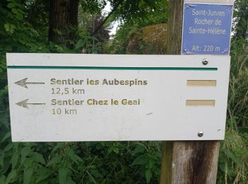
10,2 km | 13,1 km-effort
2h 58min
![](https://static1.geolcdn.com/siteimages/upload/files/1508320355ic_sort_den_pos_24dp.png)
222 m
![](https://static1.geolcdn.com/siteimages/upload/files/1508320355ic_sort_den_neg_24dp.png)
218 m
![](https://static1.geolcdn.com/siteimages/upload/files/16400158638029165_repeat_loop_refresh_sync_direction_icon.png)
Oui
RonanDAGORN
![Randonnée Marche Saint-Junien - sentier Corot - Photo](https://media.geolcdn.com/t/350/260/0c04e5b4-9df5-4f67-825f-733dda848d47.jpg&format=jpg&maxdim=2)
![Marche Marche](https://static1.geolcdn.com/sitytour/trail-icons/101.png)
Km
#2 - sentier Corot
Marche
Facile
(1)
Saint-Junien,
Nouvelle-Aquitaine,
Haute-Vienne,
France
![](/images/other/stat-length.png)
4,3 km | 5,5 km-effort
1h 30min
![](https://static1.geolcdn.com/siteimages/upload/files/1508320355ic_sort_den_pos_24dp.png)
98 m
![](https://static1.geolcdn.com/siteimages/upload/files/1508320355ic_sort_den_neg_24dp.png)
83 m
![](https://static1.geolcdn.com/siteimages/upload/files/16400158638029165_repeat_loop_refresh_sync_direction_icon.png)
Non
andrea cléa
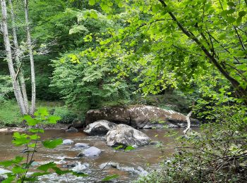
• très belle rando on longe la Glane
![Randonnée Marche Saint-Junien - Île de Chaillac - Photo](https://media.geolcdn.com/t/350/260/ext.jpg?maxdim=2&url=https%3A%2F%2Fstatic1.geolcdn.com%2Fsiteimages%2Fupload%2Ffiles%2F1553511878bg_sport_marche.png)
![Marche Marche](https://static1.geolcdn.com/sitytour/trail-icons/101.png)
Km
#3 - Île de Chaillac
Marche
Facile
Saint-Junien,
Nouvelle-Aquitaine,
Haute-Vienne,
France
![](/images/other/stat-length.png)
5,4 km | 5,8 km-effort
1h 39min
![](https://static1.geolcdn.com/siteimages/upload/files/1508320355ic_sort_den_pos_24dp.png)
31 m
![](https://static1.geolcdn.com/siteimages/upload/files/1508320355ic_sort_den_neg_24dp.png)
26 m
![](https://static1.geolcdn.com/siteimages/upload/files/16400158638029165_repeat_loop_refresh_sync_direction_icon.png)
Oui
Sentiers1960
![Randonnée Marche Saint-Junien - Chaillac - Photo](https://media.geolcdn.com/t/350/260/ext.jpg?maxdim=2&url=https%3A%2F%2Fstatic1.geolcdn.com%2Fsiteimages%2Fupload%2Ffiles%2F1553511878bg_sport_marche.png)
![Marche Marche](https://static1.geolcdn.com/sitytour/trail-icons/101.png)
Km
#4 - Chaillac
Marche
Très facile
Saint-Junien,
Nouvelle-Aquitaine,
Haute-Vienne,
France
![](/images/other/stat-length.png)
4,4 km | 4,7 km-effort
1h 22min
![](https://static1.geolcdn.com/siteimages/upload/files/1508320355ic_sort_den_pos_24dp.png)
25 m
![](https://static1.geolcdn.com/siteimages/upload/files/1508320355ic_sort_den_neg_24dp.png)
25 m
![](https://static1.geolcdn.com/siteimages/upload/files/16400158638029165_repeat_loop_refresh_sync_direction_icon.png)
Oui
Isabelle Nadaud
4 randonnées affichées sur 4
Application GPS de randonnée GRATUITE