![](/images/other/stat-length.png)
- Randonnées
- A pied
- France
- Centre-Val de Loire
- Loir-et-Cher
- Thoré-la-Rochette
Thoré-la-Rochette, Loir-et-Cher, A pied : Les meilleures randonnées, itinéraires, parcours, balades et promenades
Thoré-la-Rochette : découvrez les meilleures randonnées : 3 marche. Tous ces circuits, parcours, itinéraires et activités en plein air sont disponibles dans nos applications SityTrail pour smartphones et tablettes.
Les meilleurs parcours (3)
![Randonnée Marche Thoré-la-Rochette - Thoré-la-Rochette - Vallée et Coteaux du Loir - Photo](https://media.geolcdn.com/t/350/260/3f4c80d2-3437-4e69-84de-30a02f464543.jpg&format=jpg&maxdim=2)
![Marche Marche](https://static1.geolcdn.com/sitytour/trail-icons/101.png)
Km
Marche
![](/images/other/stat-length.png)
![](https://static1.geolcdn.com/siteimages/upload/files/1508320355ic_sort_den_pos_24dp.png)
![](https://static1.geolcdn.com/siteimages/upload/files/1508320355ic_sort_den_neg_24dp.png)
![](https://static1.geolcdn.com/siteimages/upload/files/16400158638029165_repeat_loop_refresh_sync_direction_icon.png)
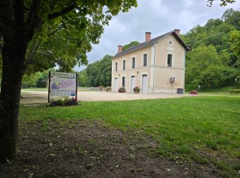
• Ce circuit en sens antihoraire commence depuis le parking à côté de la gare de Thoré-la-Rochette, 41100, au pied du B...
![Randonnée Marche Thoré-la-Rochette - Thoré-la-Rochette - Vallée et Coteaux du Loir - Photo](https://media.geolcdn.com/t/350/260/344cfef8-5ffd-42a8-843d-f0a9586064a7.jpg&format=jpg&maxdim=2)
![Marche Marche](https://static1.geolcdn.com/sitytour/trail-icons/101.png)
Km
Marche
![](/images/other/stat-length.png)
![](https://static1.geolcdn.com/siteimages/upload/files/1508320355ic_sort_den_pos_24dp.png)
![](https://static1.geolcdn.com/siteimages/upload/files/1508320355ic_sort_den_neg_24dp.png)
![](https://static1.geolcdn.com/siteimages/upload/files/16400158638029165_repeat_loop_refresh_sync_direction_icon.png)
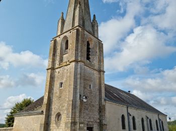
• Le parcours commence depuis le parking à côté de l’Église Saint-Denis, 10 Place de l'Église, 41100 Thoré-la-Rochette ...
![Randonnée Marche Thoré-la-Rochette - Rando de Thoré 2 - Photo](https://media.geolcdn.com/t/350/260/ext.jpg?maxdim=2&url=https%3A%2F%2Fstatic1.geolcdn.com%2Fsiteimages%2Fupload%2Ffiles%2F1553511878bg_sport_marche.png)
![Marche Marche](https://static1.geolcdn.com/sitytour/trail-icons/101.png)
Km
Marche
![](/images/other/stat-length.png)
![](https://static1.geolcdn.com/siteimages/upload/files/1508320355ic_sort_den_pos_24dp.png)
![](https://static1.geolcdn.com/siteimages/upload/files/1508320355ic_sort_den_neg_24dp.png)
![](https://static1.geolcdn.com/siteimages/upload/files/16400158638029165_repeat_loop_refresh_sync_direction_icon.png)
3 randonnées affichées sur 3
Application GPS de randonnée GRATUITE