Embres-et-Castelmaure, Aude, A pied : Les meilleures randonnées, itinéraires, parcours, balades et promenades

2 commentaires

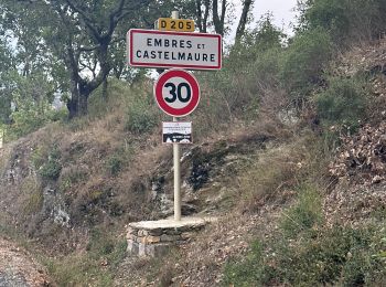
Embres-et-Castelmaure : découvrez les meilleures randonnées : 11 marche. Tous ces circuits, parcours, itinéraires et activités en plein air sont disponibles dans nos applications SityTrail pour smartphones et tablettes.


Les meilleurs parcours (11)

Randonnée Marche Embres-et-Castelmaure - Embres et Castelmaure - Photo
Marche 11.165
Km

Marche

Moyen
Embres-et-Castelmaure, Occitanie, Aude, France
11,2 km | 14,6 km-effort
3h 0min
260 m
259 m
Oui
ombrabella

• Boucle quelques pentes raides

Randonnée Marche Embres-et-Castelmaure - Embres castelmaure - Photo
Marche 17.919
Km

Marche

Très difficile
Embres-et-Castelmaure, Occitanie, Aude, France
17,9 km | 26 km-effort
4h 35min
577 m
584 m
Oui
Taupunzien

Randonnée Marche Embres-et-Castelmaure - Ambres et Castelmaure 18/10/2023 - Photo
Marche 11.052
Km

Marche

Moyen
Embres-et-Castelmaure, Occitanie, Aude, France
11,1 km | 15,6 km-effort
3h 22min
344 m
344 m
Oui
andre66

• Boucle

Randonnée Marche Embres-et-Castelmaure - TBG ACAD Embrres Castelnau final - Photo
Marche 18.013
Km

Marche

Très difficile
(1)
Embres-et-Castelmaure, Occitanie, Aude, France
18 km | 26 km-effort
4h 38min
583 m
585 m
Oui
Taupunzien

Randonnée Marche Embres-et-Castelmaure - Embers et Castelmore - Photo
Marche 11.242
Km

Marche

Moyen
Embres-et-Castelmaure, Occitanie, Aude, France
11,2 km | 15,9 km-effort
3h 23min
347 m
349 m
Oui
robertperello

• Moyen

Randonnée Marche Embres-et-Castelmaure - Embates et Castelmaure - Photo
Marche 11.092
Km

Marche

Difficile
Embres-et-Castelmaure, Occitanie, Aude, France
11,1 km | 15,7 km-effort
3h 16min
345 m
345 m
Oui
robertperello

• Pking au foyer rural

Randonnée Marche Embres-et-Castelmaure - Embres et Castelmaure - Photo
Marche 10.95
Km

Marche

Moyen
Embres-et-Castelmaure, Occitanie, Aude, France
10,9 km | 15,5 km-effort
3h 17min
344 m
340 m
Oui
ombrabella

• Boucle

Randonnée Marche Embres-et-Castelmaure - Embres er Castelmaure, vers fontaine des canelles - Photo
Marche 7.709
Km

Marche

Moyen
Embres-et-Castelmaure, Occitanie, Aude, France
7,7 km | 12 km-effort
3h 30min
323 m
323 m
Oui
Santblasi

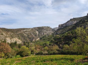
• randonnée entre vignes et roches karstiques.

Randonnée Marche Embres-et-Castelmaure - Embres et Castelmaure jp2 - Photo
Marche 12.177
Km

Marche

Moyen
(1)
Embres-et-Castelmaure, Occitanie, Aude, France
12,2 km | 16,1 km-effort
3h 48min
293 m
293 m
Oui
Jocelyne LIGER

Randonnée Marche Embres-et-Castelmaure - Embres Castelmaure - Photo
Marche 6.977
Km

Marche

Moyen
Embres-et-Castelmaure, Occitanie, Aude, France
7 km | 9,6 km-effort
2h 21min
194 m
194 m
Oui
Jocelyne LIGER

Randonnée Marche Embres-et-Castelmaure - Embres Castelmaure JP - Photo
Marche 10.715
Km

Marche

Moyen
Embres-et-Castelmaure, Occitanie, Aude, France
10,7 km | 15,3 km-effort
3h 20min
344 m
338 m
Non
Jocelyne LIGER

11 randonnées affichées sur 11

Application GPS de randonnée GRATUITE

Logo SityTrail SityTrail

IGN / Instituts géographiques

Télécharger SityTrail sur l'App Store Télécharger SityTrail sur Google Play

Logo SityTrail SityTrail World

Le monde est à vous

Télécharger SityTrail sur l'App Store Télécharger SityTrail sur Google Play Télécharger SityTrail sur Huawei AppGallery

Activités

Fermer
Mes abonnements