![](/images/other/stat-length.png)
- Randonnées
- A pied
- France
- Grand Est
- Marne
- Blancs-Coteaux
Blancs-Coteaux, Marne, A pied : Les meilleures randonnées, itinéraires, parcours, balades et promenades
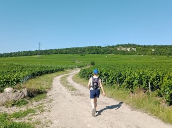
Blancs-Coteaux : découvrez les meilleures randonnées : 5 marche. Tous ces circuits, parcours, itinéraires et activités en plein air sont disponibles dans nos applications SityTrail pour smartphones et tablettes.
Les meilleurs parcours (5)
![Randonnée Marche Blancs-Coteaux - Vertus du 25-06-2023 - Photo](https://media.geolcdn.com/t/350/260/f1f2975e-4f79-4dd4-9963-eb384f3481b9.jpg&format=jpg&maxdim=2)
![Marche Marche](https://static1.geolcdn.com/sitytour/trail-icons/101.png)
Km
#1 - Vertus du 25-06-2023
Marche
Moyen
Blancs-Coteaux,
Grand Est,
Marne,
France
![](/images/other/stat-length.png)
8,1 km | 10,1 km-effort
2h 17min
![](https://static1.geolcdn.com/siteimages/upload/files/1508320355ic_sort_den_pos_24dp.png)
150 m
![](https://static1.geolcdn.com/siteimages/upload/files/1508320355ic_sort_den_neg_24dp.png)
150 m
![](https://static1.geolcdn.com/siteimages/upload/files/16400158638029165_repeat_loop_refresh_sync_direction_icon.png)
Oui
VANDERPUTTENMi
![Randonnée Marche Blancs-Coteaux - Vertus du 17/10/2019 - Photo](https://media.geolcdn.com/t/350/260/ext.jpg?maxdim=2&url=https%3A%2F%2Fstatic1.geolcdn.com%2Fsiteimages%2Fupload%2Ffiles%2F1553511878bg_sport_marche.png)
![Marche Marche](https://static1.geolcdn.com/sitytour/trail-icons/101.png)
Km
#2 - Vertus du 17/10/2019
Marche
Très facile
Blancs-Coteaux,
Grand Est,
Marne,
France
![](/images/other/stat-length.png)
15,3 km | 18,6 km-effort
4h 41min
![](https://static1.geolcdn.com/siteimages/upload/files/1508320355ic_sort_den_pos_24dp.png)
250 m
![](https://static1.geolcdn.com/siteimages/upload/files/1508320355ic_sort_den_neg_24dp.png)
250 m
![](https://static1.geolcdn.com/siteimages/upload/files/16400158638029165_repeat_loop_refresh_sync_direction_icon.png)
Oui
VANDERPUTTENMi
![Randonnée Marche Blancs-Coteaux - Vertus du 19/05/2019 - Photo](https://media.geolcdn.com/t/350/260/ext.jpg?maxdim=2&url=https%3A%2F%2Fstatic1.geolcdn.com%2Fsiteimages%2Fupload%2Ffiles%2F1553511878bg_sport_marche.png)
![Marche Marche](https://static1.geolcdn.com/sitytour/trail-icons/101.png)
Km
#3 - Vertus du 19/05/2019
Marche
Très facile
Blancs-Coteaux,
Grand Est,
Marne,
France
![](/images/other/stat-length.png)
8,1 km | 10,1 km-effort
2h 25min
![](https://static1.geolcdn.com/siteimages/upload/files/1508320355ic_sort_den_pos_24dp.png)
151 m
![](https://static1.geolcdn.com/siteimages/upload/files/1508320355ic_sort_den_neg_24dp.png)
152 m
![](https://static1.geolcdn.com/siteimages/upload/files/16400158638029165_repeat_loop_refresh_sync_direction_icon.png)
Oui
VANDERPUTTENMi
![Randonnée Marche Blancs-Coteaux - VERTUS - Photo](https://media.geolcdn.com/t/350/260/ext.jpg?maxdim=2&url=https%3A%2F%2Fstatic1.geolcdn.com%2Fsiteimages%2Fupload%2Ffiles%2F1553511878bg_sport_marche.png)
![Marche Marche](https://static1.geolcdn.com/sitytour/trail-icons/101.png)
Km
#4 - VERTUS
Marche
Moyen
Blancs-Coteaux,
Grand Est,
Marne,
France
![](/images/other/stat-length.png)
15,3 km | 18,7 km-effort
5h 8min
![](https://static1.geolcdn.com/siteimages/upload/files/1508320355ic_sort_den_pos_24dp.png)
248 m
![](https://static1.geolcdn.com/siteimages/upload/files/1508320355ic_sort_den_neg_24dp.png)
248 m
![](https://static1.geolcdn.com/siteimages/upload/files/16400158638029165_repeat_loop_refresh_sync_direction_icon.png)
Oui
explorateur
![Randonnée Marche Blancs-Coteaux - Vertus, les coteaux et le village - Photo](https://media.geolcdn.com/t/350/260/ext.jpg?maxdim=2&url=https%3A%2F%2Fstatic1.geolcdn.com%2Fsiteimages%2Fupload%2Ffiles%2F1553511878bg_sport_marche.png)
![Marche Marche](https://static1.geolcdn.com/sitytour/trail-icons/101.png)
Km
#5 - Vertus, les coteaux et le village
Marche
Très facile
Blancs-Coteaux,
Grand Est,
Marne,
France
![](/images/other/stat-length.png)
6,8 km | 8,4 km-effort
2h 17min
![](https://static1.geolcdn.com/siteimages/upload/files/1508320355ic_sort_den_pos_24dp.png)
115 m
![](https://static1.geolcdn.com/siteimages/upload/files/1508320355ic_sort_den_neg_24dp.png)
115 m
![](https://static1.geolcdn.com/siteimages/upload/files/16400158638029165_repeat_loop_refresh_sync_direction_icon.png)
Oui
pierpolmake
5 randonnées affichées sur 5