![](/images/other/stat-length.png)
- Randonnées
- A pied
- France
- Grand Est
- Bas-Rhin
- Muhlbach-sur-Bruche
Muhlbach-sur-Bruche, Bas-Rhin, A pied : Les meilleures randonnées, itinéraires, parcours, balades et promenades
Muhlbach-sur-Bruche : découvrez les meilleures randonnées : 5 marche. Tous ces circuits, parcours, itinéraires et activités en plein air sont disponibles dans nos applications SityTrail pour smartphones et tablettes.
Les meilleurs parcours (5)
![Randonnée Marche Muhlbach-sur-Bruche - Les chaumes de Grendelbruch - Photo](https://media.geolcdn.com/t/350/260/9979fa98-9676-4906-adae-3d6cfb128d71.jpg&format=jpg&maxdim=2)
![Marche Marche](https://static1.geolcdn.com/sitytour/trail-icons/101.png)
Km
Marche
![](/images/other/stat-length.png)
![](https://static1.geolcdn.com/siteimages/upload/files/1508320355ic_sort_den_pos_24dp.png)
![](https://static1.geolcdn.com/siteimages/upload/files/1508320355ic_sort_den_neg_24dp.png)
![](https://static1.geolcdn.com/siteimages/upload/files/16400158638029165_repeat_loop_refresh_sync_direction_icon.png)
• Faite le 09/05/2021. Au départ de la gare de Lutzelhouse. La montée au rocher vous fera de beaux mollets. D'après htt...
![Randonnée Marche Muhlbach-sur-Bruche - Sur les chaumes de Grendelbruch - Photo](https://media.geolcdn.com/t/350/260/ext.jpg?maxdim=2&url=https%3A%2F%2Fservices.sitytrail.com%2FGeolivesWS%2FDownloadMedia.ashx%3FTrailID%3D224365%26Media%3Dfix__20130929141354.jpg)
![Marche Marche](https://static1.geolcdn.com/sitytour/trail-icons/101.png)
Km
Marche
![](/images/other/stat-length.png)
![](https://static1.geolcdn.com/siteimages/upload/files/1508320355ic_sort_den_pos_24dp.png)
![](https://static1.geolcdn.com/siteimages/upload/files/1508320355ic_sort_den_neg_24dp.png)
![](https://static1.geolcdn.com/siteimages/upload/files/16400158638029165_repeat_loop_refresh_sync_direction_icon.png)
• Faite le 29/09/2013 avec notre fils de 9 ans, ses grands-parents et un couple d'amis. D'après : Randonnées & histoire...
![Randonnée Marche Muhlbach-sur-Bruche - Le Jardin des Fées par la cascade de Soulzbach - Photo](https://media.geolcdn.com/t/350/260/7559da18-bcb4-4d7e-98b9-d476506aeeb7.jpg&format=jpg&maxdim=2)
![Marche Marche](https://static1.geolcdn.com/sitytour/trail-icons/101.png)
Km
Marche
![](/images/other/stat-length.png)
![](https://static1.geolcdn.com/siteimages/upload/files/1508320355ic_sort_den_pos_24dp.png)
![](https://static1.geolcdn.com/siteimages/upload/files/1508320355ic_sort_den_neg_24dp.png)
![](https://static1.geolcdn.com/siteimages/upload/files/16400158638029165_repeat_loop_refresh_sync_direction_icon.png)
![Randonnée Marche Muhlbach-sur-Bruche - Muhlbach sur Bruche - Photo](https://media.geolcdn.com/t/350/260/0deceecb-7b1b-4570-9338-c68cb35535c4.jpg&format=jpg&maxdim=2)
![Marche Marche](https://static1.geolcdn.com/sitytour/trail-icons/101.png)
Km
Marche
![](/images/other/stat-length.png)
![](https://static1.geolcdn.com/siteimages/upload/files/1508320355ic_sort_den_pos_24dp.png)
![](https://static1.geolcdn.com/siteimages/upload/files/1508320355ic_sort_den_neg_24dp.png)
![](https://static1.geolcdn.com/siteimages/upload/files/16400158638029165_repeat_loop_refresh_sync_direction_icon.png)
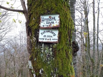
• Plusieurs points de vue. Randonnée facile, sauf le dernier tronçon un peu raide pour arriver au Hahnenberg
![Randonnée Marche Muhlbach-sur-Bruche - G - Photo](https://media.geolcdn.com/t/350/260/ext.jpg?maxdim=2&url=https%3A%2F%2Fstatic1.geolcdn.com%2Fsiteimages%2Fupload%2Ffiles%2F1553511878bg_sport_marche.png)
![Marche Marche](https://static1.geolcdn.com/sitytour/trail-icons/101.png)
Km
Marche
![](/images/other/stat-length.png)
![](https://static1.geolcdn.com/siteimages/upload/files/1508320355ic_sort_den_pos_24dp.png)
![](https://static1.geolcdn.com/siteimages/upload/files/1508320355ic_sort_den_neg_24dp.png)
![](https://static1.geolcdn.com/siteimages/upload/files/16400158638029165_repeat_loop_refresh_sync_direction_icon.png)
•
5 randonnées affichées sur 5
Application GPS de randonnée GRATUITE