![](/images/other/stat-length.png)
- Randonnées
- A pied
- France
- Auvergne-Rhône-Alpes
- Haute-Savoie
- Glières-Val-de-Borne
- Le Petit-Bornand-les-Glières
Le Petit-Bornand-les-Glières, Glières-Val-de-Borne, A pied : Les meilleures randonnées, itinéraires, parcours, balades et promenades
Le Petit-Bornand-les-Glières : découvrez les meilleures randonnées : 2 a pied, 96 marche, 1 marche nordique, 4 course à pied et 2 trail. Tous ces circuits, parcours, itinéraires et activités en plein air sont disponibles dans nos applications SityTrail pour smartphones et tablettes.
Les meilleurs parcours (105)
![Randonnée Marche Glières-Val-de-Borne - BARGY: ROCHERS DE LESCHAUX AU DEPART DE CENISE - Photo](https://media.geolcdn.com/t/350/260/5ac05f8e-3735-47a8-a18c-c0c850908ba7.jpg&format=jpg&maxdim=2)
![Marche Marche](https://static1.geolcdn.com/sitytour/trail-icons/101.png)
Km
Marche
![](/images/other/stat-length.png)
![](https://static1.geolcdn.com/siteimages/upload/files/1508320355ic_sort_den_pos_24dp.png)
![](https://static1.geolcdn.com/siteimages/upload/files/1508320355ic_sort_den_neg_24dp.png)
![](https://static1.geolcdn.com/siteimages/upload/files/16400158638029165_repeat_loop_refresh_sync_direction_icon.png)
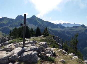
• BOUCLE A mi-chemin, dans les rochers de Leschaux, on peut admirer un jardin de cairns. Arrivé à la croix du sommet, p...
![Randonnée Marche Glières-Val-de-Borne - Petit Bornand - Pointe d'Andey 29/07/2018 - Photo](https://media.geolcdn.com/t/350/260/d11e3746-7609-4ae6-897f-3a7f87c8818d.jpg&format=jpg&maxdim=2)
![Marche Marche](https://static1.geolcdn.com/sitytour/trail-icons/101.png)
Km
Marche
![](/images/other/stat-length.png)
![](https://static1.geolcdn.com/siteimages/upload/files/1508320355ic_sort_den_pos_24dp.png)
![](https://static1.geolcdn.com/siteimages/upload/files/1508320355ic_sort_den_neg_24dp.png)
![](https://static1.geolcdn.com/siteimages/upload/files/16400158638029165_repeat_loop_refresh_sync_direction_icon.png)
• Une montée un peu sauvage car peu empruntée et une descente à réserver aux montagnards avertis car pentue, exposée et...
![Randonnée Marche Glières-Val-de-Borne - Refuge de Spé - Photo](https://media.geolcdn.com/t/350/260/ext.jpg?maxdim=2&url=https%3A%2F%2Fstatic1.geolcdn.com%2Fsiteimages%2Fupload%2Ffiles%2F1553511878bg_sport_marche.png)
![Marche Marche](https://static1.geolcdn.com/sitytour/trail-icons/101.png)
Km
Marche
![](/images/other/stat-length.png)
![](https://static1.geolcdn.com/siteimages/upload/files/1508320355ic_sort_den_pos_24dp.png)
![](https://static1.geolcdn.com/siteimages/upload/files/1508320355ic_sort_den_neg_24dp.png)
![](https://static1.geolcdn.com/siteimages/upload/files/16400158638029165_repeat_loop_refresh_sync_direction_icon.png)
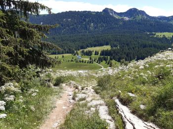
• Du restaurant chez régina au refuge de Spé
![Randonnée Marche Glières-Val-de-Borne - BARGY: LAC DE LESSY - Photo](https://media.geolcdn.com/t/350/260/06d01766-eea3-467c-b01f-e9f0d3a61660.jpg&format=jpg&maxdim=2)
![Marche Marche](https://static1.geolcdn.com/sitytour/trail-icons/101.png)
Km
Marche
![](/images/other/stat-length.png)
![](https://static1.geolcdn.com/siteimages/upload/files/1508320355ic_sort_den_pos_24dp.png)
![](https://static1.geolcdn.com/siteimages/upload/files/1508320355ic_sort_den_neg_24dp.png)
![](https://static1.geolcdn.com/siteimages/upload/files/16400158638029165_repeat_loop_refresh_sync_direction_icon.png)
• BOUCLE... live du 20240627 Belle rando, en traversée "Paradis - Cenise", aux paysages multiples. Pour éviter de termi...
![Randonnée Marche Glières-Val-de-Borne - GLIERES: TOUR DE LA MONTAGNE DES FRETES mai 2023 - Photo](https://media.geolcdn.com/t/350/260/7effa61e-f263-4a8f-86ae-6b39e4d6eab9.jpg&format=jpg&maxdim=2)
![Marche Marche](https://static1.geolcdn.com/sitytour/trail-icons/101.png)
Km
Marche
![](/images/other/stat-length.png)
![](https://static1.geolcdn.com/siteimages/upload/files/1508320355ic_sort_den_pos_24dp.png)
![](https://static1.geolcdn.com/siteimages/upload/files/1508320355ic_sort_den_neg_24dp.png)
![](https://static1.geolcdn.com/siteimages/upload/files/16400158638029165_repeat_loop_refresh_sync_direction_icon.png)
• BOUCLE... live 20230503. Roncevaux et Spée dans la neige.
![Randonnée Marche Glières-Val-de-Borne - 2022- Rochers de Leschaux - AR - Photo](https://media.geolcdn.com/t/350/260/279a636c-2a60-4284-9cdd-e6183412d2d9.jpg&format=jpg&maxdim=2)
![Marche Marche](https://static1.geolcdn.com/sitytour/trail-icons/101.png)
Km
Marche
![](/images/other/stat-length.png)
![](https://static1.geolcdn.com/siteimages/upload/files/1508320355ic_sort_den_pos_24dp.png)
![](https://static1.geolcdn.com/siteimages/upload/files/1508320355ic_sort_den_neg_24dp.png)
![](https://static1.geolcdn.com/siteimages/upload/files/16400158638029165_repeat_loop_refresh_sync_direction_icon.png)
• Aller- retour depuis Cenise. 4h30 de ballade avec les pauses. Partie de bonne heure, première en haut et les bouque...
![Randonnée Marche Glières-Val-de-Borne - GLIERES: MONUMENT - LANDRON - SOUS DINE - COL DU CABLE- SPEE - Photo](https://media.geolcdn.com/t/350/260/37935eec-de60-4844-876e-9e392482da50.jpg&format=jpg&maxdim=2)
![Marche Marche](https://static1.geolcdn.com/sitytour/trail-icons/101.png)
Km
Marche
![](/images/other/stat-length.png)
![](https://static1.geolcdn.com/siteimages/upload/files/1508320355ic_sort_den_pos_24dp.png)
![](https://static1.geolcdn.com/siteimages/upload/files/1508320355ic_sort_den_neg_24dp.png)
![](https://static1.geolcdn.com/siteimages/upload/files/16400158638029165_repeat_loop_refresh_sync_direction_icon.png)
• BOUCLE... live le 30 juin 2022 Depuis Sous Dine, en suivant l'arête "est", deux passages sont sécurisés: - l'un avec ...
![Randonnée Marche Glières-Val-de-Borne - Les Meffins - Col de Spée - Lavouillon - Les Meffins - Photo](https://media.geolcdn.com/t/350/260/8392c81d-3a36-4490-a2af-21a66d368647.jpg&format=jpg&maxdim=2)
![Marche Marche](https://static1.geolcdn.com/sitytour/trail-icons/101.png)
Km
Marche
![](/images/other/stat-length.png)
![](https://static1.geolcdn.com/siteimages/upload/files/1508320355ic_sort_den_pos_24dp.png)
![](https://static1.geolcdn.com/siteimages/upload/files/1508320355ic_sort_den_neg_24dp.png)
![](https://static1.geolcdn.com/siteimages/upload/files/16400158638029165_repeat_loop_refresh_sync_direction_icon.png)
• Belle randonnée de la mi-avril. Descente du col bien enneigée aussi la trace ne suit pas forcément le sentier. Aucune...
![Randonnée Marche Glières-Val-de-Borne - BARGY: CENISE - ROCHERS DE LESCHAUX - SOLAISON - COL DE CENISE - Photo](https://media.geolcdn.com/t/350/260/d92b2f1f-870b-476a-a83f-4d994f3f713e.jpg&format=jpg&maxdim=2)
![Marche Marche](https://static1.geolcdn.com/sitytour/trail-icons/101.png)
Km
Marche
![](/images/other/stat-length.png)
![](https://static1.geolcdn.com/siteimages/upload/files/1508320355ic_sort_den_pos_24dp.png)
![](https://static1.geolcdn.com/siteimages/upload/files/1508320355ic_sort_den_neg_24dp.png)
![](https://static1.geolcdn.com/siteimages/upload/files/16400158638029165_repeat_loop_refresh_sync_direction_icon.png)
• BOUCLE... en live 20200714 Descente des rochers de Leschaux vers Solaison: la majorité en rochers. Montée de Solaison...
![Randonnée Marche Glières-Val-de-Borne - GLIERES: TOUR DE LA MONTAGNE DES FRETES - Photo](https://media.geolcdn.com/t/350/260/cc81d0f4-1d9b-4cff-b67c-d4780d80422a.jpg&format=jpg&maxdim=2)
![Marche Marche](https://static1.geolcdn.com/sitytour/trail-icons/101.png)
Km
Marche
![](/images/other/stat-length.png)
![](https://static1.geolcdn.com/siteimages/upload/files/1508320355ic_sort_den_pos_24dp.png)
![](https://static1.geolcdn.com/siteimages/upload/files/1508320355ic_sort_den_neg_24dp.png)
![](https://static1.geolcdn.com/siteimages/upload/files/16400158638029165_repeat_loop_refresh_sync_direction_icon.png)
• Jolie randonnée en BOUCLE... en live 20200522 La descente en thalweg depuis le col de Spée en direction des chalets d...
![Randonnée Marche Glières-Val-de-Borne - les sambuis - Photo](https://media.geolcdn.com/t/350/260/b2b46f98-5a97-4620-a63b-f25cac91355e.jpg&format=jpg&maxdim=2)
![Marche Marche](https://static1.geolcdn.com/sitytour/trail-icons/101.png)
Km
Marche
![](/images/other/stat-length.png)
![](https://static1.geolcdn.com/siteimages/upload/files/1508320355ic_sort_den_pos_24dp.png)
![](https://static1.geolcdn.com/siteimages/upload/files/1508320355ic_sort_den_neg_24dp.png)
![](https://static1.geolcdn.com/siteimages/upload/files/16400158638029165_repeat_loop_refresh_sync_direction_icon.png)
• sans raquettes
![Randonnée Marche Glières-Val-de-Borne - BARGY: TRAVERSEE CENISE - LAC DE LESSY - PARADIS - Photo](https://media.geolcdn.com/t/350/260/8b55e0f8-cc53-43f3-b92b-cf31930832f2.jpg&format=jpg&maxdim=2)
![Marche Marche](https://static1.geolcdn.com/sitytour/trail-icons/101.png)
Km
Marche
![](/images/other/stat-length.png)
![](https://static1.geolcdn.com/siteimages/upload/files/1508320355ic_sort_den_pos_24dp.png)
![](https://static1.geolcdn.com/siteimages/upload/files/1508320355ic_sort_den_neg_24dp.png)
![](https://static1.geolcdn.com/siteimages/upload/files/16400158638029165_repeat_loop_refresh_sync_direction_icon.png)
• Semi-BOUCLE. En passant, laisser une voiture à Paradis (Le Pteret)... puis monter au point de départ de la rando (Cen...
![Randonnée Marche Glières-Val-de-Borne - BARGY: CENISE - LAC DE LESSY - Photo](https://media.geolcdn.com/t/350/260/00a50356-bc77-4875-b4c2-827ae4340a69.jpg&format=jpg&maxdim=2)
![Marche Marche](https://static1.geolcdn.com/sitytour/trail-icons/101.png)
Km
Marche
![](/images/other/stat-length.png)
![](https://static1.geolcdn.com/siteimages/upload/files/1508320355ic_sort_den_pos_24dp.png)
![](https://static1.geolcdn.com/siteimages/upload/files/1508320355ic_sort_den_neg_24dp.png)
![](https://static1.geolcdn.com/siteimages/upload/files/16400158638029165_repeat_loop_refresh_sync_direction_icon.png)
• Circuit faisable en aller / retour... Rajouter le temps de la descente: +01h30 ... Mais il peut aussi constituer la p...
![Randonnée Marche Glières-Val-de-Borne - La Palange (Rocher de Salin) - Photo](https://media.geolcdn.com/t/350/260/ext.jpg?maxdim=2&url=https%3A%2F%2Fservices.sitytrail.com%2FGeolivesWS%2FDownloadMedia.ashx%3FTrailID%3D983801%26Media%3Dfix__20180610112753.jpg)
![Marche Marche](https://static1.geolcdn.com/sitytour/trail-icons/101.png)
Km
Marche
![](/images/other/stat-length.png)
![](https://static1.geolcdn.com/siteimages/upload/files/1508320355ic_sort_den_pos_24dp.png)
![](https://static1.geolcdn.com/siteimages/upload/files/1508320355ic_sort_den_neg_24dp.png)
![](https://static1.geolcdn.com/siteimages/upload/files/16400158638029165_repeat_loop_refresh_sync_direction_icon.png)
• Pas de difficulté en majorité sur la piste 4 x 4 d'accès au chalet de Mayse. La crête pour de La Palange est plus sau...
![Randonnée Marche Glières-Val-de-Borne - lac de Lessy, Roc des Tours, Aiguille verte - Photo](https://media.geolcdn.com/t/350/260/ext.jpg?maxdim=2&url=https%3A%2F%2Fservices.sitytrail.com%2FGeolivesWS%2FDownloadMedia.ashx%3FTrailID%3D823853%26Media%3Dfix__20170905170850.jpg)
![Marche Marche](https://static1.geolcdn.com/sitytour/trail-icons/101.png)
Km
Marche
![](/images/other/stat-length.png)
![](https://static1.geolcdn.com/siteimages/upload/files/1508320355ic_sort_den_pos_24dp.png)
![](https://static1.geolcdn.com/siteimages/upload/files/1508320355ic_sort_den_neg_24dp.png)
![](https://static1.geolcdn.com/siteimages/upload/files/16400158638029165_repeat_loop_refresh_sync_direction_icon.png)
• belle randonnée variée et super points de vues
![Randonnée Marche Glières-Val-de-Borne - lac de Lessy, Roc des Tours, Aiguille verte - Photo](https://media.geolcdn.com/t/350/260/ext.jpg?maxdim=2&url=https%3A%2F%2Fservices.sitytrail.com%2FGeolivesWS%2FDownloadMedia.ashx%3FTrailID%3D823848%26Media%3Dfix__20170905170850.jpg)
![Marche Marche](https://static1.geolcdn.com/sitytour/trail-icons/101.png)
Km
Marche
![](/images/other/stat-length.png)
![](https://static1.geolcdn.com/siteimages/upload/files/1508320355ic_sort_den_pos_24dp.png)
![](https://static1.geolcdn.com/siteimages/upload/files/1508320355ic_sort_den_neg_24dp.png)
![](https://static1.geolcdn.com/siteimages/upload/files/16400158638029165_repeat_loop_refresh_sync_direction_icon.png)
• belle randonnée variée et super points de vues
![Randonnée Marche Glières-Val-de-Borne - BARGY: PARADIS - LAC DE LESSY - Photo](https://media.geolcdn.com/t/350/260/8aa4f626-e2dc-441f-8bce-7420813bd3f8.jpg&format=jpg&maxdim=2)
![Marche Marche](https://static1.geolcdn.com/sitytour/trail-icons/101.png)
Km
Marche
![](/images/other/stat-length.png)
![](https://static1.geolcdn.com/siteimages/upload/files/1508320355ic_sort_den_pos_24dp.png)
![](https://static1.geolcdn.com/siteimages/upload/files/1508320355ic_sort_den_neg_24dp.png)
![](https://static1.geolcdn.com/siteimages/upload/files/16400158638029165_repeat_loop_refresh_sync_direction_icon.png)
• Circuit faisable en aller / retour... Rajouter le temps de la descente: +02h00. ... Mais il peut aussi constituer la ...
![Randonnée Marche Glières-Val-de-Borne - GLIERES: TOUR DES FRETES - Photo](https://media.geolcdn.com/t/350/260/8325492f-1c1f-4dc5-a947-394def2c4df1.jpg&format=jpg&maxdim=2)
![Marche Marche](https://static1.geolcdn.com/sitytour/trail-icons/101.png)
Km
Marche
![](/images/other/stat-length.png)
![](https://static1.geolcdn.com/siteimages/upload/files/1508320355ic_sort_den_pos_24dp.png)
![](https://static1.geolcdn.com/siteimages/upload/files/1508320355ic_sort_den_neg_24dp.png)
![](https://static1.geolcdn.com/siteimages/upload/files/16400158638029165_repeat_loop_refresh_sync_direction_icon.png)
• BOUCLE... live du 20241031 ... départ de chez "La Constance"
![Randonnée Marche Glières-Val-de-Borne - Pk Cenise - Col du Rasoir_11.07.2021 - Photo](https://media.geolcdn.com/t/350/260/1612fb7d-aa9b-45de-9afe-69790bab8db4.jpg&format=jpg&maxdim=2)
![Marche Marche](https://static1.geolcdn.com/sitytour/trail-icons/101.png)
Km
Marche
![](/images/other/stat-length.png)
![](https://static1.geolcdn.com/siteimages/upload/files/1508320355ic_sort_den_pos_24dp.png)
![](https://static1.geolcdn.com/siteimages/upload/files/1508320355ic_sort_den_neg_24dp.png)
![](https://static1.geolcdn.com/siteimages/upload/files/16400158638029165_repeat_loop_refresh_sync_direction_icon.png)
![Randonnée Marche Glières-Val-de-Borne - pas du roc depuis glières - Photo](https://media.geolcdn.com/t/350/260/eac8234d-9d49-49c0-a170-61e740f1ab61.jpg&format=jpg&maxdim=2)
![Marche Marche](https://static1.geolcdn.com/sitytour/trail-icons/101.png)
Km
Marche
![](/images/other/stat-length.png)
![](https://static1.geolcdn.com/siteimages/upload/files/1508320355ic_sort_den_pos_24dp.png)
![](https://static1.geolcdn.com/siteimages/upload/files/1508320355ic_sort_den_neg_24dp.png)
![](https://static1.geolcdn.com/siteimages/upload/files/16400158638029165_repeat_loop_refresh_sync_direction_icon.png)
20 randonnées affichées sur 105
Application GPS de randonnée GRATUITE