


13,2 km | 24 km-effort
Presle : découvrez les meilleures randonnées : 16 marche. Tous ces circuits, parcours, itinéraires et activités en plein air sont disponibles dans nos applications SityTrail pour smartphones et tablettes.
Marche


• départ prodin
Marche
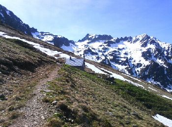
• Depuis Prodin, le Chapotet par les refuges de la Grande montagne de Presle et des Plattières. Retour par le chalet de...
Marche
• La route forestière qui permet de rejoindre la chapelle de Prodin depuis Presle n'est pas goudronnée. Il faut compter...
Marche
• Le sentier de la fin de la descente de la crete se perd completement dans les vernes et autres buissons .
Marche
• Depuis Prodin, le Chapotet par les refuges de la Grande montagne de Presle et des Plattières. Retour par le chalet de...
Marche
• De la Pointe de Rognier, cime d'une altitude supérieure à 2000 m, la plus septentrionale du Massif de Belledonne, le ...

Marche
• Enlever 60 m détour vers le col de la perche. En voiture aller 1H15 par l'autoroute jusqu'à Pontchara puis aller au ...
Marche
• j'ai effectué un petit aller retour en plus au sommet dénivelé réel 1130
Marche
Marche
Marche
Marche
Marche
Marche
Marche
Marche
16 randonnées affichées sur 16
Application GPS de randonnée GRATUITE
 SityTrail
IGN / Instituts géographiques
SityTrail World
Le monde est à vous