![](/images/other/stat-length.png)
- Randonnées
- A pied
- Espagne
- Aragon
- Huesca
- Puértolas
Puértolas, Huesca, A pied : Les meilleures randonnées, itinéraires, parcours, balades et promenades
Puértolas : découvrez les meilleures randonnées : 3 marche. Tous ces circuits, parcours, itinéraires et activités en plein air sont disponibles dans nos applications SityTrail pour smartphones et tablettes.
Les meilleurs parcours (3)
![Randonnée Marche Puértolas - Les Sestrales depuis le col de Plana Canal - Photo](https://media.geolcdn.com/t/350/260/aa043a3b-808c-4320-b2bd-83fe386b8b3c.jpg&format=jpg&maxdim=2)
![Marche Marche](https://static1.geolcdn.com/sitytour/trail-icons/101.png)
Km
Marche
![](/images/other/stat-length.png)
![](https://static1.geolcdn.com/siteimages/upload/files/1508320355ic_sort_den_pos_24dp.png)
![](https://static1.geolcdn.com/siteimages/upload/files/1508320355ic_sort_den_neg_24dp.png)
![](https://static1.geolcdn.com/siteimages/upload/files/16400158638029165_repeat_loop_refresh_sync_direction_icon.png)
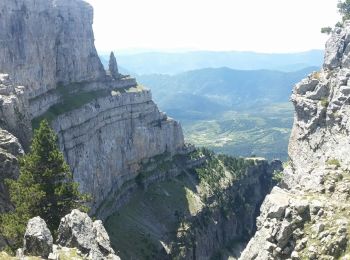
• Depuis Escalona 18 km dont 10 km de piste acceptable. Très beau belvédère sur le cayon d'Anisclo et ses plateaux env...
![Randonnée Marche Puértolas - SESTRALES BAJO - Photo](https://media.geolcdn.com/t/350/260/5f36201a-6efe-4392-809e-cc57fb1ae425.jpg&format=jpg&maxdim=2)
![Marche Marche](https://static1.geolcdn.com/sitytour/trail-icons/101.png)
Km
Marche
![](/images/other/stat-length.png)
![](https://static1.geolcdn.com/siteimages/upload/files/1508320355ic_sort_den_pos_24dp.png)
![](https://static1.geolcdn.com/siteimages/upload/files/1508320355ic_sort_den_neg_24dp.png)
![](https://static1.geolcdn.com/siteimages/upload/files/16400158638029165_repeat_loop_refresh_sync_direction_icon.png)
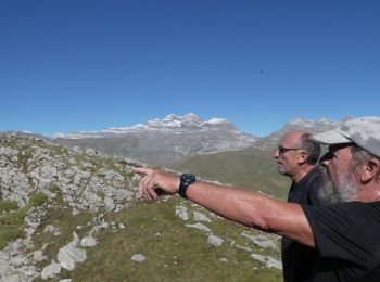
• Très belle balade. Dommage que nous ayons raté le sommet du Sestrales Alto !! pour le sestrales bajo .
![Randonnée Marche Puértolas - Bestué - Nerin - Photo](https://media.geolcdn.com/t/350/260/ext.jpg?maxdim=2&url=https%3A%2F%2Fstatic1.geolcdn.com%2Fsiteimages%2Fupload%2Ffiles%2F1553511878bg_sport_marche.png)
![Marche Marche](https://static1.geolcdn.com/sitytour/trail-icons/101.png)
Km
Marche
![](/images/other/stat-length.png)
![](https://static1.geolcdn.com/siteimages/upload/files/1508320355ic_sort_den_pos_24dp.png)
![](https://static1.geolcdn.com/siteimages/upload/files/1508320355ic_sort_den_neg_24dp.png)
![](https://static1.geolcdn.com/siteimages/upload/files/16400158638029165_repeat_loop_refresh_sync_direction_icon.png)
3 randonnées affichées sur 3
Application GPS de randonnée GRATUITE