![](/images/other/stat-length.png)
- Randonnées
- A pied
- Allemagne
- Hesse
- Lahn-Dill-Kreis
Lahn-Dill-Kreis, Hesse, A pied : Les meilleures randonnées, itinéraires, parcours, balades et promenades
Lahn-Dill-Kreis : découvrez les meilleures randonnées : 52 a pied. Tous ces circuits, parcours, itinéraires et activités en plein air sont disponibles dans nos applications SityTrail pour smartphones et tablettes.
Les meilleurs parcours (52)
![Randonnée A pied Dillenburg - Rothaarsteigspur Wacholderweg - Photo](https://media.geolcdn.com/t/350/260/cbb8f72e-0452-4ff1-9042-d8a824c6414c.jpeg&format=jpg&maxdim=2)
![A pied A pied](https://static1.geolcdn.com/sitytour/trail-icons/100.png)
Km
A pied
![](/images/other/stat-length.png)
![](https://static1.geolcdn.com/siteimages/upload/files/1508320355ic_sort_den_pos_24dp.png)
![](https://static1.geolcdn.com/siteimages/upload/files/1508320355ic_sort_den_neg_24dp.png)
![](https://static1.geolcdn.com/siteimages/upload/files/16400158638029165_repeat_loop_refresh_sync_direction_icon.png)
• Randonnée créée par Rothaarsteigverein.
![Randonnée A pied Wetzlar - NATURLEHRPFAD Leitz-Park - Photo](https://media.geolcdn.com/t/350/260/44dfa84a-602c-465d-be19-fe033755af59.jpeg&format=jpg&maxdim=2)
![A pied A pied](https://static1.geolcdn.com/sitytour/trail-icons/100.png)
Km
A pied
![](/images/other/stat-length.png)
![](https://static1.geolcdn.com/siteimages/upload/files/1508320355ic_sort_den_pos_24dp.png)
![](https://static1.geolcdn.com/siteimages/upload/files/1508320355ic_sort_den_neg_24dp.png)
![](https://static1.geolcdn.com/siteimages/upload/files/16400158638029165_repeat_loop_refresh_sync_direction_icon.png)
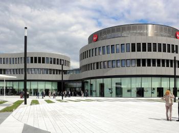
• Randonnée créée par Leitz-Park GmbH. Symbole: red circle with white Leica
![Randonnée A pied Schöffengrund - Rundwanderweg Reiskirchen - Schwalbach - Photo](https://media.geolcdn.com/t/350/260/2af2144b-7b22-48d0-8a60-03e616dcdb72.jpeg&format=jpg&maxdim=2)
![A pied A pied](https://static1.geolcdn.com/sitytour/trail-icons/100.png)
Km
A pied
![](/images/other/stat-length.png)
![](https://static1.geolcdn.com/siteimages/upload/files/1508320355ic_sort_den_pos_24dp.png)
![](https://static1.geolcdn.com/siteimages/upload/files/1508320355ic_sort_den_neg_24dp.png)
![](https://static1.geolcdn.com/siteimages/upload/files/16400158638029165_repeat_loop_refresh_sync_direction_icon.png)
• Randonnée créée par Naturpark Taunus. Symbole: Grünes Eichenblatt auf weißem Grund
![Randonnée A pied Haiger - Rothaarsteig-Spur Dill-Bergtour - Photo](https://media.geolcdn.com/t/350/260/7aedcd41-5b62-4247-a70d-40d58104e322.jpeg&format=jpg&maxdim=2)
![A pied A pied](https://static1.geolcdn.com/sitytour/trail-icons/100.png)
Km
A pied
![](/images/other/stat-length.png)
![](https://static1.geolcdn.com/siteimages/upload/files/1508320355ic_sort_den_pos_24dp.png)
![](https://static1.geolcdn.com/siteimages/upload/files/1508320355ic_sort_den_neg_24dp.png)
![](https://static1.geolcdn.com/siteimages/upload/files/16400158638029165_repeat_loop_refresh_sync_direction_icon.png)
• Rothaarsteig Site web: https://www.rothaarsteig.de/
![Randonnée A pied Hohenahr - Extratour Zweiburgentour - Photo](https://media.geolcdn.com/t/350/260/85a8254c-d21a-4f61-a2b5-a242100db251.jpeg&format=jpg&maxdim=2)
![A pied A pied](https://static1.geolcdn.com/sitytour/trail-icons/100.png)
Km
A pied
![](/images/other/stat-length.png)
![](https://static1.geolcdn.com/siteimages/upload/files/1508320355ic_sort_den_pos_24dp.png)
![](https://static1.geolcdn.com/siteimages/upload/files/1508320355ic_sort_den_neg_24dp.png)
![](https://static1.geolcdn.com/siteimages/upload/files/16400158638029165_repeat_loop_refresh_sync_direction_icon.png)
• Randonnée créée par Naturpark Lahn-Dill-Bergland. Symbole: stilisierter Berg und Fluß in Grün auf weißem Grund
![Randonnée A pied Bischoffen - Extratour Aartalsee-Panoramaweg - Photo](https://media.geolcdn.com/t/350/260/5e61300b-9391-4233-99ff-7c8ba142d44b.jpeg&format=jpg&maxdim=2)
![A pied A pied](https://static1.geolcdn.com/sitytour/trail-icons/100.png)
Km
A pied
![](/images/other/stat-length.png)
![](https://static1.geolcdn.com/siteimages/upload/files/1508320355ic_sort_den_pos_24dp.png)
![](https://static1.geolcdn.com/siteimages/upload/files/1508320355ic_sort_den_neg_24dp.png)
![](https://static1.geolcdn.com/siteimages/upload/files/16400158638029165_repeat_loop_refresh_sync_direction_icon.png)
• Randonnée créée par Naturpark Lahn-Dill-Bergland. Symbole: stilisierter Berg und Fluß in Grün auf weißem Grund
![Randonnée A pied Siegbach - Extratour Hohe Straße - Photo](https://media.geolcdn.com/t/350/260/a0ec8e56-121d-467e-9e58-90343818cd05.jpeg&format=jpg&maxdim=2)
![A pied A pied](https://static1.geolcdn.com/sitytour/trail-icons/100.png)
Km
A pied
![](/images/other/stat-length.png)
![](https://static1.geolcdn.com/siteimages/upload/files/1508320355ic_sort_den_pos_24dp.png)
![](https://static1.geolcdn.com/siteimages/upload/files/1508320355ic_sort_den_neg_24dp.png)
![](https://static1.geolcdn.com/siteimages/upload/files/16400158638029165_repeat_loop_refresh_sync_direction_icon.png)
• Randonnée créée par Naturpark Lahn-Dill-Bergland. Symbole: stilisierter Berg und Fluß in Grün auf weißem Grund
![Randonnée A pied Mittenaar - Extratour Bickener Rittersporn - Photo](https://media.geolcdn.com/t/350/260/3ba974b5-ce81-4772-b4f3-28ae1b85203d.jpeg&format=jpg&maxdim=2)
![A pied A pied](https://static1.geolcdn.com/sitytour/trail-icons/100.png)
Km
A pied
![](/images/other/stat-length.png)
![](https://static1.geolcdn.com/siteimages/upload/files/1508320355ic_sort_den_pos_24dp.png)
![](https://static1.geolcdn.com/siteimages/upload/files/1508320355ic_sort_den_neg_24dp.png)
![](https://static1.geolcdn.com/siteimages/upload/files/16400158638029165_repeat_loop_refresh_sync_direction_icon.png)
• Randonnée créée par Naturpark Lahn-Dill-Bergland. Symbole: stilisierter Berg und Fluß in Grün auf weißem Grund
![Randonnée A pied Dillenburg - Extratour Kuckucksweg - Photo](https://media.geolcdn.com/t/350/260/03c55f57-b7a3-477b-be22-bfe6cf2a58aa.jpeg&format=jpg&maxdim=2)
![A pied A pied](https://static1.geolcdn.com/sitytour/trail-icons/100.png)
Km
A pied
![](/images/other/stat-length.png)
![](https://static1.geolcdn.com/siteimages/upload/files/1508320355ic_sort_den_pos_24dp.png)
![](https://static1.geolcdn.com/siteimages/upload/files/1508320355ic_sort_den_neg_24dp.png)
![](https://static1.geolcdn.com/siteimages/upload/files/16400158638029165_repeat_loop_refresh_sync_direction_icon.png)
• Randonnée créée par Naturpark Lahn-Dill-Bergland. Symbole: stilisierter Berg und Fluß in Grün auf weißem Grund
![Randonnée A pied Dillenburg - Permanent Wanderweg Wanderfreunde Aartal e. V. - Photo](https://media.geolcdn.com/t/350/260/1c97d602-5b4e-4162-b305-3bbb151bda73.jpeg&format=jpg&maxdim=2)
![A pied A pied](https://static1.geolcdn.com/sitytour/trail-icons/100.png)
Km
A pied
![](/images/other/stat-length.png)
![](https://static1.geolcdn.com/siteimages/upload/files/1508320355ic_sort_den_pos_24dp.png)
![](https://static1.geolcdn.com/siteimages/upload/files/1508320355ic_sort_den_neg_24dp.png)
![](https://static1.geolcdn.com/siteimages/upload/files/16400158638029165_repeat_loop_refresh_sync_direction_icon.png)
• Randonnée créée par Wanderfreunde Aartal e. V..
![Randonnée A pied Breitscheid - nördlicher Rothaarsteig-Zuweg Breitscheid - Photo](https://media.geolcdn.com/t/350/260/f6df4c18-1a71-4df4-a191-c52aff299f54.jpeg&format=jpg&maxdim=2)
![A pied A pied](https://static1.geolcdn.com/sitytour/trail-icons/100.png)
Km
A pied
![](/images/other/stat-length.png)
![](https://static1.geolcdn.com/siteimages/upload/files/1508320355ic_sort_den_pos_24dp.png)
![](https://static1.geolcdn.com/siteimages/upload/files/1508320355ic_sort_den_neg_24dp.png)
![](https://static1.geolcdn.com/siteimages/upload/files/16400158638029165_repeat_loop_refresh_sync_direction_icon.png)
• Randonnée créée par Rothaarsteigverein.
![Randonnée A pied Herborn - H12 Laternenweg - Photo](https://media.geolcdn.com/t/350/260/481e8f48-104d-47f6-938d-c0e964e2b0c7.jpeg&format=jpg&maxdim=2)
![A pied A pied](https://static1.geolcdn.com/sitytour/trail-icons/100.png)
Km
A pied
![](/images/other/stat-length.png)
![](https://static1.geolcdn.com/siteimages/upload/files/1508320355ic_sort_den_pos_24dp.png)
![](https://static1.geolcdn.com/siteimages/upload/files/1508320355ic_sort_den_neg_24dp.png)
![](https://static1.geolcdn.com/siteimages/upload/files/16400158638029165_repeat_loop_refresh_sync_direction_icon.png)
• Randonnée créée par Westerwaldverein Herborn e.V..
![Randonnée A pied Greifenstein - Burg Greifenstein Weg 10 km - Photo](https://media.geolcdn.com/t/350/260/481e8f48-104d-47f6-938d-c0e964e2b0c7.jpeg&format=jpg&maxdim=2)
![A pied A pied](https://static1.geolcdn.com/sitytour/trail-icons/100.png)
Km
A pied
![](/images/other/stat-length.png)
![](https://static1.geolcdn.com/siteimages/upload/files/1508320355ic_sort_den_pos_24dp.png)
![](https://static1.geolcdn.com/siteimages/upload/files/1508320355ic_sort_den_neg_24dp.png)
![](https://static1.geolcdn.com/siteimages/upload/files/16400158638029165_repeat_loop_refresh_sync_direction_icon.png)
• Randonnée créée par Wanderfreunde Katzenfurt. Symbole: Roter Text PW 1 10 auf gelbem Grund
![Randonnée A pied Herborn - Extratour Dernbachwiesen - Photo](https://media.geolcdn.com/t/350/260/bfdf75bc-c640-4d8a-b2ca-436f519c82fb.jpeg&format=jpg&maxdim=2)
![A pied A pied](https://static1.geolcdn.com/sitytour/trail-icons/100.png)
Km
A pied
![](/images/other/stat-length.png)
![](https://static1.geolcdn.com/siteimages/upload/files/1508320355ic_sort_den_pos_24dp.png)
![](https://static1.geolcdn.com/siteimages/upload/files/1508320355ic_sort_den_neg_24dp.png)
![](https://static1.geolcdn.com/siteimages/upload/files/16400158638029165_repeat_loop_refresh_sync_direction_icon.png)
• Randonnée créée par Naturpark Lahn-Dill-Bergland. Symbole: stilisierter Berg und Fluß in Grün auf weißem Grund
![Randonnée A pied Braunfels - Zugangsweg zum Lahnwanderweg (ab Lahnbahnhof bei Leun) - Photo](https://media.geolcdn.com/t/350/260/237f9260-18dc-45b8-abae-a1893542f556.jpeg&format=jpg&maxdim=2)
![A pied A pied](https://static1.geolcdn.com/sitytour/trail-icons/100.png)
Km
A pied
![](/images/other/stat-length.png)
![](https://static1.geolcdn.com/siteimages/upload/files/1508320355ic_sort_den_pos_24dp.png)
![](https://static1.geolcdn.com/siteimages/upload/files/1508320355ic_sort_den_neg_24dp.png)
![](https://static1.geolcdn.com/siteimages/upload/files/16400158638029165_repeat_loop_refresh_sync_direction_icon.png)
• Randonnée créée par Lahntal Tourismus Verband e.V.. Symbole: Stilisiertes LW in roter Schrift auf gelbem Grund mit r...
![Randonnée A pied Mittenaar - PW Lahn-Dill-Berglandmarathon - Photo](https://media.geolcdn.com/t/350/260/ba598f11-ede9-47ba-82eb-fba0239fa5b9.jpeg&format=jpg&maxdim=2)
![A pied A pied](https://static1.geolcdn.com/sitytour/trail-icons/100.png)
Km
A pied
![](/images/other/stat-length.png)
![](https://static1.geolcdn.com/siteimages/upload/files/1508320355ic_sort_den_pos_24dp.png)
![](https://static1.geolcdn.com/siteimages/upload/files/1508320355ic_sort_den_neg_24dp.png)
![](https://static1.geolcdn.com/siteimages/upload/files/16400158638029165_repeat_loop_refresh_sync_direction_icon.png)
• Randonnée créée par Wanderfreunde Herborn e.V..
![Randonnée A pied Herborn - H9 - Photo](https://media.geolcdn.com/t/350/260/b2d4c1c3-97c3-4a41-ac5d-e68808f4acc6.jpeg&format=jpg&maxdim=2)
![A pied A pied](https://static1.geolcdn.com/sitytour/trail-icons/100.png)
Km
A pied
![](/images/other/stat-length.png)
![](https://static1.geolcdn.com/siteimages/upload/files/1508320355ic_sort_den_pos_24dp.png)
![](https://static1.geolcdn.com/siteimages/upload/files/1508320355ic_sort_den_neg_24dp.png)
![](https://static1.geolcdn.com/siteimages/upload/files/16400158638029165_repeat_loop_refresh_sync_direction_icon.png)
• Randonnée créée par Westerwaldverein Herborn e.V..
![Randonnée A pied Herborn - H8 Hörre-Weg - Photo](https://media.geolcdn.com/t/350/260/b2d4c1c3-97c3-4a41-ac5d-e68808f4acc6.jpeg&format=jpg&maxdim=2)
![A pied A pied](https://static1.geolcdn.com/sitytour/trail-icons/100.png)
Km
A pied
![](/images/other/stat-length.png)
![](https://static1.geolcdn.com/siteimages/upload/files/1508320355ic_sort_den_pos_24dp.png)
![](https://static1.geolcdn.com/siteimages/upload/files/1508320355ic_sort_den_neg_24dp.png)
![](https://static1.geolcdn.com/siteimages/upload/files/16400158638029165_repeat_loop_refresh_sync_direction_icon.png)
• Randonnée créée par Westerwaldverein Herborn e.V..
![Randonnée A pied Herborn - H6 Homberg-Weg - Photo](https://media.geolcdn.com/t/350/260/f2f73495-db60-43a0-a497-206859c853ea.jpeg&format=jpg&maxdim=2)
![A pied A pied](https://static1.geolcdn.com/sitytour/trail-icons/100.png)
Km
A pied
![](/images/other/stat-length.png)
![](https://static1.geolcdn.com/siteimages/upload/files/1508320355ic_sort_den_pos_24dp.png)
![](https://static1.geolcdn.com/siteimages/upload/files/1508320355ic_sort_den_neg_24dp.png)
![](https://static1.geolcdn.com/siteimages/upload/files/16400158638029165_repeat_loop_refresh_sync_direction_icon.png)
• Randonnée créée par Westerwaldverein Herborn e.V..
![Randonnée A pied Herborn - H10 Jahrtausendweg - Photo](https://media.geolcdn.com/t/350/260/f2f73495-db60-43a0-a497-206859c853ea.jpeg&format=jpg&maxdim=2)
![A pied A pied](https://static1.geolcdn.com/sitytour/trail-icons/100.png)
Km
A pied
![](/images/other/stat-length.png)
![](https://static1.geolcdn.com/siteimages/upload/files/1508320355ic_sort_den_pos_24dp.png)
![](https://static1.geolcdn.com/siteimages/upload/files/1508320355ic_sort_den_neg_24dp.png)
![](https://static1.geolcdn.com/siteimages/upload/files/16400158638029165_repeat_loop_refresh_sync_direction_icon.png)
• Randonnée créée par Westerwaldverein Herborn e.V..
20 randonnées affichées sur 52
Application GPS de randonnée GRATUITE