![](/images/other/stat-length.png)
Wetter, Landkreis Marburg-Biedenkopf, A pied : Les meilleures randonnées, itinéraires, parcours, balades et promenades
Wetter : découvrez les meilleures randonnées : 7 a pied. Tous ces circuits, parcours, itinéraires et activités en plein air sont disponibles dans nos applications SityTrail pour smartphones et tablettes.
Les meilleurs parcours (7)
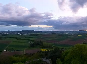
![Randonnée A pied Wetter - [W2] Kleine Wollenbergrunde (Wetschaft Senke) - Photo](https://media.geolcdn.com/t/350/260/ext.jpg?maxdim=2&url=https%3A%2F%2Fmedia.geolcdn.com%2Ff%2Fdaed682b-00fa-4e8a-8c85-f140ab90c6d6.jpeg)
![A pied A pied](https://static1.geolcdn.com/sitytour/trail-icons/100.png)
Km
A pied
![](/images/other/stat-length.png)
![](https://static1.geolcdn.com/siteimages/upload/files/1508320355ic_sort_den_pos_24dp.png)
![](https://static1.geolcdn.com/siteimages/upload/files/1508320355ic_sort_den_neg_24dp.png)
![](https://static1.geolcdn.com/siteimages/upload/files/16400158638029165_repeat_loop_refresh_sync_direction_icon.png)
• Randonnée créée par Wandcerverein Wetter (Hessen). Symbole: Gelbe Bezeichnung W2 auf schwarzem Grund
![Randonnée A pied Wetter - [W1] Wollenberg Rundwanderweg - Photo](https://media.geolcdn.com/t/350/260/ext.jpg?maxdim=2&url=https%3A%2F%2Fmedia.geolcdn.com%2Ff%2Fdaed682b-00fa-4e8a-8c85-f140ab90c6d6.jpeg)
![A pied A pied](https://static1.geolcdn.com/sitytour/trail-icons/100.png)
Km
A pied
![](/images/other/stat-length.png)
![](https://static1.geolcdn.com/siteimages/upload/files/1508320355ic_sort_den_pos_24dp.png)
![](https://static1.geolcdn.com/siteimages/upload/files/1508320355ic_sort_den_neg_24dp.png)
![](https://static1.geolcdn.com/siteimages/upload/files/16400158638029165_repeat_loop_refresh_sync_direction_icon.png)
• Randonnée créée par Wandcerverein Wetter (Hessen). Symbole: Gelbe Bezeichnung W1 auf schwarzem Grund
![Randonnée A pied Wetter - Extratour Rotes Wasser - Photo](https://media.geolcdn.com/t/350/260/ext.jpg?maxdim=2&url=https%3A%2F%2Fmedia.geolcdn.com%2Ff%2F5c3abddb-1c0d-4b92-ab20-4ebc8dc91edf.jpeg)
![A pied A pied](https://static1.geolcdn.com/sitytour/trail-icons/100.png)
Km
A pied
![](/images/other/stat-length.png)
![](https://static1.geolcdn.com/siteimages/upload/files/1508320355ic_sort_den_pos_24dp.png)
![](https://static1.geolcdn.com/siteimages/upload/files/1508320355ic_sort_den_neg_24dp.png)
![](https://static1.geolcdn.com/siteimages/upload/files/16400158638029165_repeat_loop_refresh_sync_direction_icon.png)
• Randonnée créée par Burgwald Touristservice. Symbole: Rotes R auf weißem Spiegel
![Randonnée A pied Wetter - Extratour Stirnhelle - Photo](https://media.geolcdn.com/t/350/260/ext.jpg?maxdim=2&url=https%3A%2F%2Fmedia.geolcdn.com%2Ff%2F7963eb90-1895-446e-968c-d8f54577a232.jpeg)
![A pied A pied](https://static1.geolcdn.com/sitytour/trail-icons/100.png)
Km
A pied
![](/images/other/stat-length.png)
![](https://static1.geolcdn.com/siteimages/upload/files/1508320355ic_sort_den_pos_24dp.png)
![](https://static1.geolcdn.com/siteimages/upload/files/1508320355ic_sort_den_neg_24dp.png)
![](https://static1.geolcdn.com/siteimages/upload/files/16400158638029165_repeat_loop_refresh_sync_direction_icon.png)
• Randonnée créée par Burgwald Touristservice. Symbole: Rotes S auf weißem Spiegel
![Randonnée A pied Wetter - Extratour Christenberg - Photo](https://media.geolcdn.com/t/350/260/ext.jpg?maxdim=2&url=https%3A%2F%2Fmedia.geolcdn.com%2Ff%2F5a680fba-91a9-4983-b579-adb5750a977a.jpeg)
![A pied A pied](https://static1.geolcdn.com/sitytour/trail-icons/100.png)
Km
A pied
![](/images/other/stat-length.png)
![](https://static1.geolcdn.com/siteimages/upload/files/1508320355ic_sort_den_pos_24dp.png)
![](https://static1.geolcdn.com/siteimages/upload/files/1508320355ic_sort_den_neg_24dp.png)
![](https://static1.geolcdn.com/siteimages/upload/files/16400158638029165_repeat_loop_refresh_sync_direction_icon.png)
• Randonnée créée par Burgwald Touristservice. Symbole: Rotes C auf weißem Spiegel
![Randonnée A pied Wetter - Extratour Gisonenpfad - Photo](https://media.geolcdn.com/t/350/260/ext.jpg?maxdim=2&url=https%3A%2F%2Fmedia.geolcdn.com%2Ff%2F50e7b00a-ff6b-4f18-bc7b-20f9b76f94b8.jpeg)
![A pied A pied](https://static1.geolcdn.com/sitytour/trail-icons/100.png)
Km
A pied
![](/images/other/stat-length.png)
![](https://static1.geolcdn.com/siteimages/upload/files/1508320355ic_sort_den_pos_24dp.png)
![](https://static1.geolcdn.com/siteimages/upload/files/1508320355ic_sort_den_neg_24dp.png)
![](https://static1.geolcdn.com/siteimages/upload/files/16400158638029165_repeat_loop_refresh_sync_direction_icon.png)
• Randonnée créée par Wanderfreunde Treisbach. Symbole: Rotes GP auf weißem Spiegel
![Randonnée A pied Wetter - Kuckucksweg Mellnau - Photo](https://media.geolcdn.com/t/350/260/ext.jpg?maxdim=2&url=https%3A%2F%2Fmedia.geolcdn.com%2Ff%2F2c0ad9bb-8318-40c2-8438-312ec5146589.jpeg)
![A pied A pied](https://static1.geolcdn.com/sitytour/trail-icons/100.png)
Km
A pied
![](/images/other/stat-length.png)
![](https://static1.geolcdn.com/siteimages/upload/files/1508320355ic_sort_den_pos_24dp.png)
![](https://static1.geolcdn.com/siteimages/upload/files/1508320355ic_sort_den_neg_24dp.png)
![](https://static1.geolcdn.com/siteimages/upload/files/16400158638029165_repeat_loop_refresh_sync_direction_icon.png)
• Randonnée créée par Aktionsgemeinschaft "Rettet den Burgwald". Symbole: Dunkelblaues "K" auf hellblauem Spiegel
7 randonnées affichées sur 7
Application GPS de randonnée GRATUITE