![](/images/other/stat-length.png)
- Randonnées
- A pied
- Allemagne
- Rhénanie-du-Nord-Westphalie
- Hochsauerlandkreis
- Schmallenberg
Schmallenberg, Hochsauerlandkreis, A pied : Les meilleures randonnées, itinéraires, parcours, balades et promenades
Schmallenberg : découvrez les meilleures randonnées : 76 a pied et 1 marche. Tous ces circuits, parcours, itinéraires et activités en plein air sont disponibles dans nos applications SityTrail pour smartphones et tablettes.
Les meilleurs parcours (77)
![Randonnée A pied Schmallenberg - Rothaarsteig-Spur Sorper-Panoramapfad - Photo](https://media.geolcdn.com/t/350/260/c4f741b1-b9a0-4dc7-ba6a-4c6410fff635.jpeg&format=jpg&maxdim=2)
![A pied A pied](https://static1.geolcdn.com/sitytour/trail-icons/100.png)
Km
A pied
![](/images/other/stat-length.png)
![](https://static1.geolcdn.com/siteimages/upload/files/1508320355ic_sort_den_pos_24dp.png)
![](https://static1.geolcdn.com/siteimages/upload/files/1508320355ic_sort_den_neg_24dp.png)
![](https://static1.geolcdn.com/siteimages/upload/files/16400158638029165_repeat_loop_refresh_sync_direction_icon.png)
• Rothaarsteig Site web: https://www.rothaarsteig.de/
![Randonnée A pied Schmallenberg - Kleins Wiese Rundwanderweg A3 - Photo](https://media.geolcdn.com/t/350/260/d8b53981-914c-408f-9360-870a03ace0f6.jpeg&format=jpg&maxdim=2)
![A pied A pied](https://static1.geolcdn.com/sitytour/trail-icons/100.png)
Km
A pied
![](/images/other/stat-length.png)
![](https://static1.geolcdn.com/siteimages/upload/files/1508320355ic_sort_den_pos_24dp.png)
![](https://static1.geolcdn.com/siteimages/upload/files/1508320355ic_sort_den_neg_24dp.png)
![](https://static1.geolcdn.com/siteimages/upload/files/16400158638029165_repeat_loop_refresh_sync_direction_icon.png)
• Randonnée créée par Sauerländischer Gebirgsverein.
![Randonnée A pied Schmallenberg - Rothaarsteig-Spur Wisent-Pfad - Photo](https://media.geolcdn.com/t/350/260/739bef70-f43e-455b-88a6-cf76aa4741c0.jpeg&format=jpg&maxdim=2)
![A pied A pied](https://static1.geolcdn.com/sitytour/trail-icons/100.png)
Km
A pied
![](/images/other/stat-length.png)
![](https://static1.geolcdn.com/siteimages/upload/files/1508320355ic_sort_den_pos_24dp.png)
![](https://static1.geolcdn.com/siteimages/upload/files/1508320355ic_sort_den_neg_24dp.png)
![](https://static1.geolcdn.com/siteimages/upload/files/16400158638029165_repeat_loop_refresh_sync_direction_icon.png)
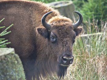
• Randonnée créée par Rothaarsteig e.V.. Symbole: Wisent
![Randonnée A pied Schmallenberg - Schwedensteig - Heidenstrasse - Photo](https://media.geolcdn.com/t/350/260/ce929ad8-d1a9-4148-92f5-96ea487e29b1.jpeg&format=jpg&maxdim=2)
![A pied A pied](https://static1.geolcdn.com/sitytour/trail-icons/100.png)
Km
A pied
![](/images/other/stat-length.png)
![](https://static1.geolcdn.com/siteimages/upload/files/1508320355ic_sort_den_pos_24dp.png)
![](https://static1.geolcdn.com/siteimages/upload/files/1508320355ic_sort_den_neg_24dp.png)
![](https://static1.geolcdn.com/siteimages/upload/files/16400158638029165_repeat_loop_refresh_sync_direction_icon.png)
• Randonnée créée par Sauerländischer Gebirgsverein (SGV).
![Randonnée A pied Schmallenberg - Rothaarsteig-Spur Kahler Asten-Steig, R - Photo](https://media.geolcdn.com/t/350/260/699f8bcf-a066-4167-ab43-6397391307ad.jpeg&format=jpg&maxdim=2)
![A pied A pied](https://static1.geolcdn.com/sitytour/trail-icons/100.png)
Km
A pied
![](/images/other/stat-length.png)
![](https://static1.geolcdn.com/siteimages/upload/files/1508320355ic_sort_den_pos_24dp.png)
![](https://static1.geolcdn.com/siteimages/upload/files/1508320355ic_sort_den_neg_24dp.png)
![](https://static1.geolcdn.com/siteimages/upload/files/16400158638029165_repeat_loop_refresh_sync_direction_icon.png)
• Randonnée créée par Rothaarsteig e.V.. Symbole: liegendes, weißes R auf schwarzem Grund
![Randonnée A pied Schmallenberg - Rothaarsteig-Zuweg Oberkirchen - Photo](https://media.geolcdn.com/t/350/260/a8671909-f2c3-4789-a13d-bfb9e87594a3.jpeg&format=jpg&maxdim=2)
![A pied A pied](https://static1.geolcdn.com/sitytour/trail-icons/100.png)
Km
A pied
![](/images/other/stat-length.png)
![](https://static1.geolcdn.com/siteimages/upload/files/1508320355ic_sort_den_pos_24dp.png)
![](https://static1.geolcdn.com/siteimages/upload/files/1508320355ic_sort_den_neg_24dp.png)
![](https://static1.geolcdn.com/siteimages/upload/files/16400158638029165_repeat_loop_refresh_sync_direction_icon.png)
• Randonnée créée par Rothaarsteigverein.
![Randonnée A pied Schmallenberg - Waldarbeiter- und Försterpfad - Photo](https://media.geolcdn.com/t/350/260/f2ed0de9-f834-46b4-95c7-f614332ed1de.jpeg&format=jpg&maxdim=2)
![A pied A pied](https://static1.geolcdn.com/sitytour/trail-icons/100.png)
Km
A pied
![](/images/other/stat-length.png)
![](https://static1.geolcdn.com/siteimages/upload/files/1508320355ic_sort_den_pos_24dp.png)
![](https://static1.geolcdn.com/siteimages/upload/files/1508320355ic_sort_den_neg_24dp.png)
![](https://static1.geolcdn.com/siteimages/upload/files/16400158638029165_repeat_loop_refresh_sync_direction_icon.png)
• Randonnée créée par Dorfgemeinschaft Latrop e.V.. Symbole: Försterhut
![Randonnée A pied Schmallenberg - Dorlar Rundweg D12 - Photo](https://media.geolcdn.com/t/350/260/25076564-8bb3-4830-92b9-c03f2cfdda5c.jpeg&format=jpg&maxdim=2)
![A pied A pied](https://static1.geolcdn.com/sitytour/trail-icons/100.png)
Km
A pied
![](/images/other/stat-length.png)
![](https://static1.geolcdn.com/siteimages/upload/files/1508320355ic_sort_den_pos_24dp.png)
![](https://static1.geolcdn.com/siteimages/upload/files/1508320355ic_sort_den_neg_24dp.png)
![](https://static1.geolcdn.com/siteimages/upload/files/16400158638029165_repeat_loop_refresh_sync_direction_icon.png)
• Randonnée créée par Sauerländischer Gebirgsverein.
![Randonnée A pied Schmallenberg - Golddorf-Route Grafschaft - Photo](https://media.geolcdn.com/t/350/260/d5fb544e-4c40-43a5-afe7-9f0b7a73e6c0.jpeg&format=jpg&maxdim=2)
![A pied A pied](https://static1.geolcdn.com/sitytour/trail-icons/100.png)
Km
A pied
![](/images/other/stat-length.png)
![](https://static1.geolcdn.com/siteimages/upload/files/1508320355ic_sort_den_pos_24dp.png)
![](https://static1.geolcdn.com/siteimages/upload/files/1508320355ic_sort_den_neg_24dp.png)
![](https://static1.geolcdn.com/siteimages/upload/files/16400158638029165_repeat_loop_refresh_sync_direction_icon.png)
• Randonnée créée par Sauerländischer Gebirgsverein.
![Randonnée A pied Schmallenberg - Golddorf-Route Lenne - Photo](https://media.geolcdn.com/t/350/260/60c5f73f-e6b1-4db3-8b3f-2f4bc53a336a.jpeg&format=jpg&maxdim=2)
![A pied A pied](https://static1.geolcdn.com/sitytour/trail-icons/100.png)
Km
A pied
![](/images/other/stat-length.png)
![](https://static1.geolcdn.com/siteimages/upload/files/1508320355ic_sort_den_pos_24dp.png)
![](https://static1.geolcdn.com/siteimages/upload/files/1508320355ic_sort_den_neg_24dp.png)
![](https://static1.geolcdn.com/siteimages/upload/files/16400158638029165_repeat_loop_refresh_sync_direction_icon.png)
• Randonnée créée par Sauerländischer Gebirgsverein.
![Randonnée A pied Schmallenberg - Kleins Wiese Rundwanderweg A2 - Photo](https://media.geolcdn.com/t/350/260/d8b53981-914c-408f-9360-870a03ace0f6.jpeg&format=jpg&maxdim=2)
![A pied A pied](https://static1.geolcdn.com/sitytour/trail-icons/100.png)
Km
A pied
![](/images/other/stat-length.png)
![](https://static1.geolcdn.com/siteimages/upload/files/1508320355ic_sort_den_pos_24dp.png)
![](https://static1.geolcdn.com/siteimages/upload/files/1508320355ic_sort_den_neg_24dp.png)
![](https://static1.geolcdn.com/siteimages/upload/files/16400158638029165_repeat_loop_refresh_sync_direction_icon.png)
• Randonnée créée par Sauerländischer Gebirgsverein.
![Randonnée A pied Schmallenberg - Kleins Wiese Rundwanderweg A1 - Photo](https://media.geolcdn.com/t/350/260/d8b53981-914c-408f-9360-870a03ace0f6.jpeg&format=jpg&maxdim=2)
![A pied A pied](https://static1.geolcdn.com/sitytour/trail-icons/100.png)
Km
A pied
![](/images/other/stat-length.png)
![](https://static1.geolcdn.com/siteimages/upload/files/1508320355ic_sort_den_pos_24dp.png)
![](https://static1.geolcdn.com/siteimages/upload/files/1508320355ic_sort_den_neg_24dp.png)
![](https://static1.geolcdn.com/siteimages/upload/files/16400158638029165_repeat_loop_refresh_sync_direction_icon.png)
• Randonnée créée par Sauerländischer Gebirgsverein.
![Randonnée A pied Schmallenberg - Golddorf-Route Oberhenneborn - Photo](https://media.geolcdn.com/t/350/260/30968daa-130b-4801-8489-20e347f8fe75.jpeg&format=jpg&maxdim=2)
![A pied A pied](https://static1.geolcdn.com/sitytour/trail-icons/100.png)
Km
A pied
![](/images/other/stat-length.png)
![](https://static1.geolcdn.com/siteimages/upload/files/1508320355ic_sort_den_pos_24dp.png)
![](https://static1.geolcdn.com/siteimages/upload/files/1508320355ic_sort_den_neg_24dp.png)
![](https://static1.geolcdn.com/siteimages/upload/files/16400158638029165_repeat_loop_refresh_sync_direction_icon.png)
• Randonnée créée par Sauerländischer Gebirgsverein.
![Randonnée A pied Schmallenberg - Niederberndorf Rundwanderweg NB2 - Photo](https://media.geolcdn.com/t/350/260/35fd5b5c-cbe0-43f7-ace4-2cea074a3de3.jpeg&format=jpg&maxdim=2)
![A pied A pied](https://static1.geolcdn.com/sitytour/trail-icons/100.png)
Km
A pied
![](/images/other/stat-length.png)
![](https://static1.geolcdn.com/siteimages/upload/files/1508320355ic_sort_den_pos_24dp.png)
![](https://static1.geolcdn.com/siteimages/upload/files/1508320355ic_sort_den_neg_24dp.png)
![](https://static1.geolcdn.com/siteimages/upload/files/16400158638029165_repeat_loop_refresh_sync_direction_icon.png)
• Randonnée créée par Sauerländischer Gebirgsverein.
![Randonnée A pied Schmallenberg - Golddorf-Route Kirchrarbach - Photo](https://media.geolcdn.com/t/350/260/56af3185-88b7-4ab7-a1ee-48f409146e5a.jpeg&format=jpg&maxdim=2)
![A pied A pied](https://static1.geolcdn.com/sitytour/trail-icons/100.png)
Km
A pied
![](/images/other/stat-length.png)
![](https://static1.geolcdn.com/siteimages/upload/files/1508320355ic_sort_den_pos_24dp.png)
![](https://static1.geolcdn.com/siteimages/upload/files/1508320355ic_sort_den_neg_24dp.png)
![](https://static1.geolcdn.com/siteimages/upload/files/16400158638029165_repeat_loop_refresh_sync_direction_icon.png)
• Randonnée créée par Sauerländischer Gebirgsverein.
![Randonnée A pied Schmallenberg - Lenne Rundweg LE2 - Photo](https://media.geolcdn.com/t/350/260/d0a67414-8200-4b80-a092-bf34a5725c21.jpeg&format=jpg&maxdim=2)
![A pied A pied](https://static1.geolcdn.com/sitytour/trail-icons/100.png)
Km
A pied
![](/images/other/stat-length.png)
![](https://static1.geolcdn.com/siteimages/upload/files/1508320355ic_sort_den_pos_24dp.png)
![](https://static1.geolcdn.com/siteimages/upload/files/1508320355ic_sort_den_neg_24dp.png)
![](https://static1.geolcdn.com/siteimages/upload/files/16400158638029165_repeat_loop_refresh_sync_direction_icon.png)
• Randonnée créée par Sauerländischer Gebirgsverein.
![Randonnée A pied Schmallenberg - Unterm Nonnenstein Rundweg A3 - Photo](https://media.geolcdn.com/t/350/260/98e24bf9-de3d-417b-8443-1a8583804aad.jpeg&format=jpg&maxdim=2)
![A pied A pied](https://static1.geolcdn.com/sitytour/trail-icons/100.png)
Km
A pied
![](/images/other/stat-length.png)
![](https://static1.geolcdn.com/siteimages/upload/files/1508320355ic_sort_den_pos_24dp.png)
![](https://static1.geolcdn.com/siteimages/upload/files/1508320355ic_sort_den_neg_24dp.png)
![](https://static1.geolcdn.com/siteimages/upload/files/16400158638029165_repeat_loop_refresh_sync_direction_icon.png)
• Randonnée créée par Sauerländischer Gebirgsverein.
![Randonnée A pied Schmallenberg - Golddorf-Route Westfeld, G - Photo](https://media.geolcdn.com/t/350/260/699f8bcf-a066-4167-ab43-6397391307ad.jpeg&format=jpg&maxdim=2)
![A pied A pied](https://static1.geolcdn.com/sitytour/trail-icons/100.png)
Km
A pied
![](/images/other/stat-length.png)
![](https://static1.geolcdn.com/siteimages/upload/files/1508320355ic_sort_den_pos_24dp.png)
![](https://static1.geolcdn.com/siteimages/upload/files/1508320355ic_sort_den_neg_24dp.png)
![](https://static1.geolcdn.com/siteimages/upload/files/16400158638029165_repeat_loop_refresh_sync_direction_icon.png)
• Randonnée créée par Sauerländischer Gebirgsverein.
![Randonnée A pied Schmallenberg - Mechterkuse Rundweg A2 - Photo](https://media.geolcdn.com/t/350/260/8c5e909d-f063-43a2-b49b-6bf781ede75f.jpeg&format=jpg&maxdim=2)
![A pied A pied](https://static1.geolcdn.com/sitytour/trail-icons/100.png)
Km
A pied
![](/images/other/stat-length.png)
![](https://static1.geolcdn.com/siteimages/upload/files/1508320355ic_sort_den_pos_24dp.png)
![](https://static1.geolcdn.com/siteimages/upload/files/1508320355ic_sort_den_neg_24dp.png)
![](https://static1.geolcdn.com/siteimages/upload/files/16400158638029165_repeat_loop_refresh_sync_direction_icon.png)
• Randonnée créée par Sauerländischer Gebirgsverein.
![Randonnée A pied Schmallenberg - Mechterkuse Rundweg A1 - Photo](https://media.geolcdn.com/t/350/260/8c5e909d-f063-43a2-b49b-6bf781ede75f.jpeg&format=jpg&maxdim=2)
![A pied A pied](https://static1.geolcdn.com/sitytour/trail-icons/100.png)
Km
A pied
![](/images/other/stat-length.png)
![](https://static1.geolcdn.com/siteimages/upload/files/1508320355ic_sort_den_pos_24dp.png)
![](https://static1.geolcdn.com/siteimages/upload/files/1508320355ic_sort_den_neg_24dp.png)
![](https://static1.geolcdn.com/siteimages/upload/files/16400158638029165_repeat_loop_refresh_sync_direction_icon.png)
• Randonnée créée par Sauerländischer Gebirgsverein.
20 randonnées affichées sur 77
Application GPS de randonnée GRATUITE