![](/images/other/stat-length.png)
- Randonnées
- A pied
- Allemagne
- Bavière
- Landkreis Cham
- Rettenbach
Rettenbach, Landkreis Cham, A pied : Les meilleures randonnées, itinéraires, parcours, balades et promenades
Rettenbach : découvrez les meilleures randonnées : 2 a pied. Tous ces circuits, parcours, itinéraires et activités en plein air sont disponibles dans nos applications SityTrail pour smartphones et tablettes.
Les meilleurs parcours (2)
![Randonnée A pied Rettenbach - Wilder Mann 149, Naturpark Vorderer Bayerischer Wald - Photo](https://media.geolcdn.com/t/350/260/530773e7-0c8c-4fad-ab0c-c5185028f559.jpeg&format=jpg&maxdim=2)
![A pied A pied](https://static1.geolcdn.com/sitytour/trail-icons/100.png)
Km
A pied
![](/images/other/stat-length.png)
![](https://static1.geolcdn.com/siteimages/upload/files/1508320355ic_sort_den_pos_24dp.png)
![](https://static1.geolcdn.com/siteimages/upload/files/1508320355ic_sort_den_neg_24dp.png)
![](https://static1.geolcdn.com/siteimages/upload/files/16400158638029165_repeat_loop_refresh_sync_direction_icon.png)
• Randonnée créée par Verein Naturpark Vorderer Bayerischer Wald e.V.. Symbole: Auf einem rechteckigen weißen Grund in...
![Randonnée A pied Rettenbach - Rundweg Hölle - Photo](https://media.geolcdn.com/t/350/260/341294d3-5eda-4b50-a960-3eb760a86047.jpeg&format=jpg&maxdim=2)
![A pied A pied](https://static1.geolcdn.com/sitytour/trail-icons/100.png)
Km
A pied
![](/images/other/stat-length.png)
![](https://static1.geolcdn.com/siteimages/upload/files/1508320355ic_sort_den_pos_24dp.png)
![](https://static1.geolcdn.com/siteimages/upload/files/1508320355ic_sort_den_neg_24dp.png)
![](https://static1.geolcdn.com/siteimages/upload/files/16400158638029165_repeat_loop_refresh_sync_direction_icon.png)
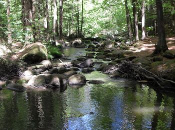
• Symbole: Weißes, rechteckiges Schild mit rotem Rand, oben rote Aufschrift "Rundweg Hölle", unten roter Richtungspfeil...
2 randonnées affichées sur 2
Application GPS de randonnée GRATUITE