![](/images/other/stat-length.png)
- Randonnées
- A pied
- Autriche
- Tyrol
- Bezirk Kufstein
- Gemeinde Münster
Gemeinde Münster, Bezirk Kufstein, A pied : Les meilleures randonnées, itinéraires, parcours, balades et promenades
Gemeinde Münster : découvrez les meilleures randonnées : 2 a pied et 1 marche. Tous ces circuits, parcours, itinéraires et activités en plein air sont disponibles dans nos applications SityTrail pour smartphones et tablettes.
Les meilleurs parcours (3)
![Randonnée Marche Gemeinde Münster - Münster - Pertisau / Jour 4 - Photo](https://media.geolcdn.com/t/350/260/ext.jpg?maxdim=2&url=https%3A%2F%2Fmedia.geolcdn.com%2Ff%2Fb088d002-39a2-4a6a-ada5-3710d2cbcb1d.jpg)
![Marche Marche](https://static1.geolcdn.com/sitytour/trail-icons/101.png)
Km
#1 - Münster - Pertisau / Jour 4
Marche
Difficile
Gemeinde Münster,
Tyrol,
Bezirk Kufstein,
Autriche
![](/images/other/stat-length.png)
12,1 km | 23 km-effort
3h 49min
![](https://static1.geolcdn.com/siteimages/upload/files/1508320355ic_sort_den_pos_24dp.png)
869 m
![](https://static1.geolcdn.com/siteimages/upload/files/1508320355ic_sort_den_neg_24dp.png)
616 m
![](https://static1.geolcdn.com/siteimages/upload/files/16400158638029165_repeat_loop_refresh_sync_direction_icon.png)
Non
Greg813
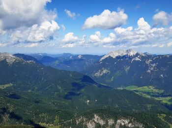
• Trek de 8 jours dans le Tyrol autrichien avec Mettons le Monde en Marche. Parcours de la voie de l'Aigle de Langkampf...
![Randonnée A pied Gemeinde Münster - 20 - Photo](https://media.geolcdn.com/t/350/260/ext.jpg?maxdim=2&url=https%3A%2F%2Fmedia.geolcdn.com%2Ff%2Faaab4df0-f896-4b33-ba5a-71a4119b1f76.jpeg)
![A pied A pied](https://static1.geolcdn.com/sitytour/trail-icons/100.png)
Km
#2 - 20
A pied
Facile
Gemeinde Münster,
Tyrol,
Bezirk Kufstein,
Autriche
![](/images/other/stat-length.png)
8,7 km | 18,7 km-effort
4h 15min
![](https://static1.geolcdn.com/siteimages/upload/files/1508320355ic_sort_den_pos_24dp.png)
1006 m
![](https://static1.geolcdn.com/siteimages/upload/files/1508320355ic_sort_den_neg_24dp.png)
3 m
![](https://static1.geolcdn.com/siteimages/upload/files/16400158638029165_repeat_loop_refresh_sync_direction_icon.png)
Non
SityTrail - itinéraires balisés pédestres
![Randonnée A pied Gemeinde Münster - Steinapfelsteig 412 - Photo](https://media.geolcdn.com/t/350/260/ext.jpg?maxdim=2&url=https%3A%2F%2Fstatic1.geolcdn.com%2Fsiteimages%2Fupload%2Ffiles%2F1545311037marcheuse_200dpi.jpg)
![A pied A pied](https://static1.geolcdn.com/sitytour/trail-icons/100.png)
Km
#3 - Steinapfelsteig 412
A pied
Facile
Gemeinde Münster,
Tyrol,
Bezirk Kufstein,
Autriche
![](/images/other/stat-length.png)
3,9 km | 6,9 km-effort
1h 33min
![](https://static1.geolcdn.com/siteimages/upload/files/1508320355ic_sort_den_pos_24dp.png)
0 m
![](https://static1.geolcdn.com/siteimages/upload/files/1508320355ic_sort_den_neg_24dp.png)
893 m
![](https://static1.geolcdn.com/siteimages/upload/files/16400158638029165_repeat_loop_refresh_sync_direction_icon.png)
Non
SityTrail - itinéraires balisés pédestres
3 randonnées affichées sur 3
Application GPS de randonnée GRATUITE