![](/images/other/stat-length.png)
- Randonnées
- A pied
- Autriche
- Styrie
- Bezirk Liezen
- Liezen
Liezen, Bezirk Liezen, A pied : Les meilleures randonnées, itinéraires, parcours, balades et promenades
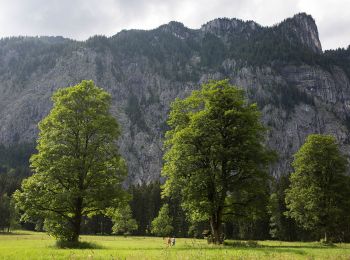
Liezen : découvrez les meilleures randonnées : 9 a pied. Tous ces circuits, parcours, itinéraires et activités en plein air sont disponibles dans nos applications SityTrail pour smartphones et tablettes.
Les meilleurs parcours (9)
![Randonnée A pied Liezen - Rote-Wand-Tour - Photo](https://media.geolcdn.com/t/350/260/a0063925-0cd5-4d46-b729-602845e851bb.jpeg&format=jpg&maxdim=2)
![A pied A pied](https://static1.geolcdn.com/sitytour/trail-icons/100.png)
Km
A pied
![](/images/other/stat-length.png)
![](https://static1.geolcdn.com/siteimages/upload/files/1508320355ic_sort_den_pos_24dp.png)
![](https://static1.geolcdn.com/siteimages/upload/files/1508320355ic_sort_den_neg_24dp.png)
![](https://static1.geolcdn.com/siteimages/upload/files/16400158638029165_repeat_loop_refresh_sync_direction_icon.png)
• Randonnée créée par Stadtgemeinde Liezen. Symbole: red and green sign with white arrow and white lettering
![Randonnée A pied Liezen - Hochmölbinghütten-Runde - Photo](https://media.geolcdn.com/t/350/260/b73c6122-278c-4075-b491-54e1cb9b784f.jpeg&format=jpg&maxdim=2)
![A pied A pied](https://static1.geolcdn.com/sitytour/trail-icons/100.png)
Km
A pied
![](/images/other/stat-length.png)
![](https://static1.geolcdn.com/siteimages/upload/files/1508320355ic_sort_den_pos_24dp.png)
![](https://static1.geolcdn.com/siteimages/upload/files/1508320355ic_sort_den_neg_24dp.png)
![](https://static1.geolcdn.com/siteimages/upload/files/16400158638029165_repeat_loop_refresh_sync_direction_icon.png)
• Randonnée créée par Tourismusverband Weißenbach bei Liezen. Symbole: Braune Alu-Tafel bzw. Richtungspfeil
![Randonnée A pied Liezen - Hinteregger-Runde - Photo](https://media.geolcdn.com/t/350/260/38f0928e-9a4f-4ed8-baaa-658570e3b68b.jpeg&format=jpg&maxdim=2)
![A pied A pied](https://static1.geolcdn.com/sitytour/trail-icons/100.png)
Km
A pied
![](/images/other/stat-length.png)
![](https://static1.geolcdn.com/siteimages/upload/files/1508320355ic_sort_den_pos_24dp.png)
![](https://static1.geolcdn.com/siteimages/upload/files/1508320355ic_sort_den_neg_24dp.png)
![](https://static1.geolcdn.com/siteimages/upload/files/16400158638029165_repeat_loop_refresh_sync_direction_icon.png)
• Randonnée créée par Tourismusverband Weißenbach bei Liezen. Symbole: Weiße Alu-Tafel bzw. Richtungspfeil
![Randonnée A pied Liezen - Bammer Schurl-Steig-Runde - Photo](https://media.geolcdn.com/t/350/260/b73c6122-278c-4075-b491-54e1cb9b784f.jpeg&format=jpg&maxdim=2)
![A pied A pied](https://static1.geolcdn.com/sitytour/trail-icons/100.png)
Km
A pied
![](/images/other/stat-length.png)
![](https://static1.geolcdn.com/siteimages/upload/files/1508320355ic_sort_den_pos_24dp.png)
![](https://static1.geolcdn.com/siteimages/upload/files/1508320355ic_sort_den_neg_24dp.png)
![](https://static1.geolcdn.com/siteimages/upload/files/16400158638029165_repeat_loop_refresh_sync_direction_icon.png)
• Randonnée créée par Tourismusverband Weißenbach bei Liezen. Symbole: Violette Alu-Tafel bzw. Richtungspfeil
![Randonnée A pied Liezen - Golfplatz-Runde - Photo](https://media.geolcdn.com/t/350/260/0ccc9bec-ffea-4775-b79c-4ee275568969.jpeg&format=jpg&maxdim=2)
![A pied A pied](https://static1.geolcdn.com/sitytour/trail-icons/100.png)
Km
A pied
![](/images/other/stat-length.png)
![](https://static1.geolcdn.com/siteimages/upload/files/1508320355ic_sort_den_pos_24dp.png)
![](https://static1.geolcdn.com/siteimages/upload/files/1508320355ic_sort_den_neg_24dp.png)
![](https://static1.geolcdn.com/siteimages/upload/files/16400158638029165_repeat_loop_refresh_sync_direction_icon.png)
• Randonnée créée par Tourismusverband Weißenbach bei Liezen. Symbole: Orange Alu-Tafel bzw. Richtungspfeil
![Randonnée A pied Liezen - Hermann von Wissmann-Weg - Photo](https://media.geolcdn.com/t/350/260/0ccc9bec-ffea-4775-b79c-4ee275568969.jpeg&format=jpg&maxdim=2)
![A pied A pied](https://static1.geolcdn.com/sitytour/trail-icons/100.png)
Km
A pied
![](/images/other/stat-length.png)
![](https://static1.geolcdn.com/siteimages/upload/files/1508320355ic_sort_den_pos_24dp.png)
![](https://static1.geolcdn.com/siteimages/upload/files/1508320355ic_sort_den_neg_24dp.png)
![](https://static1.geolcdn.com/siteimages/upload/files/16400158638029165_repeat_loop_refresh_sync_direction_icon.png)
• Randonnée créée par Tourismusverband Weißenbach bei Liezen. Symbole: Rote Alu-Tafel bzw. Richtungspfeil
![Randonnée A pied Liezen - Zur kleinen Schale-Runde - Photo](https://media.geolcdn.com/t/350/260/5ab4177a-b824-4488-b817-3f43d7cd46cf.jpeg&format=jpg&maxdim=2)
![A pied A pied](https://static1.geolcdn.com/sitytour/trail-icons/100.png)
Km
A pied
![](/images/other/stat-length.png)
![](https://static1.geolcdn.com/siteimages/upload/files/1508320355ic_sort_den_pos_24dp.png)
![](https://static1.geolcdn.com/siteimages/upload/files/1508320355ic_sort_den_neg_24dp.png)
![](https://static1.geolcdn.com/siteimages/upload/files/16400158638029165_repeat_loop_refresh_sync_direction_icon.png)
• Randonnée créée par Tourismusverband Weißenbach bei Liezen. Symbole: Blaue Alu-Tafel bzw. Richtungspfeil
![Randonnée A pied Liezen - Weißenbacher Rundwanderweg - Photo](https://media.geolcdn.com/t/350/260/749f24e3-9174-4149-804e-ec9a2a405137.jpeg&format=jpg&maxdim=2)
![A pied A pied](https://static1.geolcdn.com/sitytour/trail-icons/100.png)
Km
A pied
![](/images/other/stat-length.png)
![](https://static1.geolcdn.com/siteimages/upload/files/1508320355ic_sort_den_pos_24dp.png)
![](https://static1.geolcdn.com/siteimages/upload/files/1508320355ic_sort_den_neg_24dp.png)
![](https://static1.geolcdn.com/siteimages/upload/files/16400158638029165_repeat_loop_refresh_sync_direction_icon.png)
• Randonnée créée par Tourismusverband Weißenbach bei Liezen. Symbole: Gelbe Alu-Tafel bzw. Richtungspfeil
![Randonnée A pied Liezen - Schlagerbauer-Runde - Photo](https://media.geolcdn.com/t/350/260/ext.jpg?maxdim=2&url=https%3A%2F%2Fstatic1.geolcdn.com%2Fsiteimages%2Fupload%2Ffiles%2F1545311037marcheuse_200dpi.jpg)
![A pied A pied](https://static1.geolcdn.com/sitytour/trail-icons/100.png)
Km
A pied
![](/images/other/stat-length.png)
![](https://static1.geolcdn.com/siteimages/upload/files/1508320355ic_sort_den_pos_24dp.png)
![](https://static1.geolcdn.com/siteimages/upload/files/1508320355ic_sort_den_neg_24dp.png)
![](https://static1.geolcdn.com/siteimages/upload/files/16400158638029165_repeat_loop_refresh_sync_direction_icon.png)
• Randonnée créée par Tourismusverband Weißenbach bei Liezen. Symbole: Grüne Alu-Tafel bzw. Richtungspfeil
9 randonnées affichées sur 9
Application GPS de randonnée GRATUITE