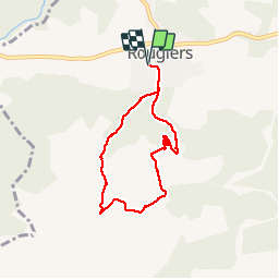
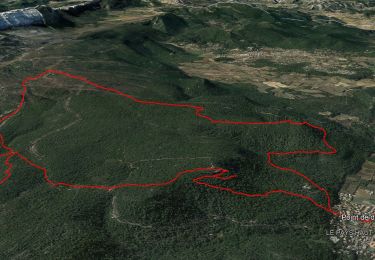
![](/images/other/stat-length.png)
![Excursión Senderismo Rougiers - chapelle et ancien castrum de Saint-Jean - Photo](https://media.geolcdn.com/t/1900/400/ext.pjpeg?maxdim=2&url=https%3A%2F%2Fservices.sitytrail.com%2FGeolivesWS%2FDownloadMedia.ashx%3FTrailID%3D979441%26Media%3Dfix__20180603133323.jpg)
chapelle et ancien castrum de Saint-Jean
amiral13
Usuario GUIDE
![Longitud](/images/other/stat-length.png)
![Altitud máxima](https://static1.geolcdn.com/siteimages/upload/files/1508320355ic_sort_altitude_max_24dp.png)
![Desnivel positivo](https://static1.geolcdn.com/siteimages/upload/files/1508320355ic_sort_den_pos_24dp.png)
![Km-Effort](/images/other/stat-length.png)
![Altitud mínima](https://static1.geolcdn.com/siteimages/upload/files/1508320355ic_sort_altitude_min_24dp.png)
![Desnivel negativo](https://static1.geolcdn.com/siteimages/upload/files/1508320355ic_sort_den_neg_24dp.png)
![Boucle](https://static1.geolcdn.com/siteimages/upload/files/16400158638029165_repeat_loop_refresh_sync_direction_icon.png)
![Senderismo](https://static1.geolcdn.com/sitytour/trail-icons/101.png)
2h44
Dificultad : Fácil
![Escanee este código QR para abrir la excursión en la aplicación SityTrail](https://capi.geolives.com/qq0zvz2zws4bq2lad0pu/sitytour/trails/979441/qr.png?size=200)
Aplicación GPS de excursión GRATIS
A propósito
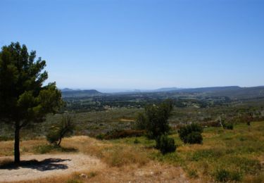
Ruta Senderismo de 6,9 km a descubrir en Provenza-Alpes-Costa Azul, Var, Rougiers. Esta ruta ha sido propuesta por amiral13.
Descripción
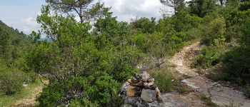
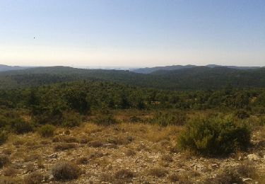
ballade agréable en grande partie en sous-bois.
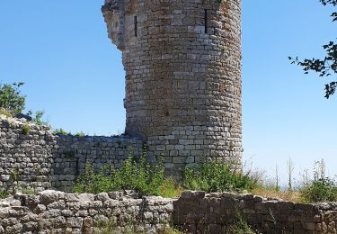
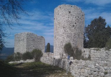
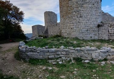
A la descente la visite de l'ancien hameau utilise un sentier un peu plus scabreux.
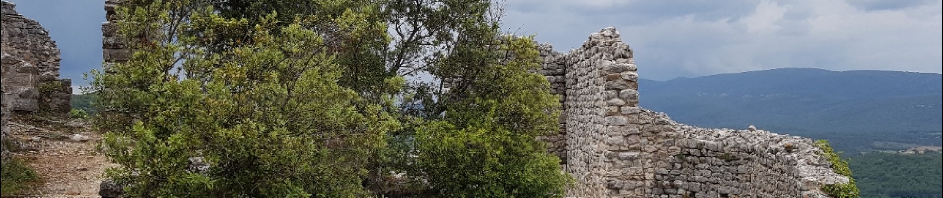
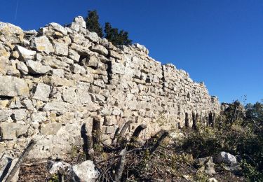
Au niveau du point 3 vous pouvez prendre à gauche pr rallier plus directement la chapelle par des sentes qui longent des barres rocheuses.
Localización
Comentarios
Excursiones cerca
![Excursión Senderismo Rougiers - SityTrail - Rougiers, Piégu, la fontaine de la Guillandière, le Castrum - Photo](https://media.geolcdn.com/t/375/260/81ba1a87-303b-4205-b673-8a1be5b2eb7f.jpg&format=jpg&maxdim=2)
![Senderismo Senderismo](https://static1.geolcdn.com/sitytour/trail-icons/101.png)
Senderismo
![](/images/other/stat-length.png)
![](https://static1.geolcdn.com/siteimages/upload/files/16400158638029165_repeat_loop_refresh_sync_direction_icon.png)
![Excursión Bici de montaña Rougiers - Crêtes de la Sainte Baume et d'Agnis, l'intégrale à VTT - Photo](https://media.geolcdn.com/t/375/260/ext.jpg?maxdim=2&url=https%3A%2F%2Fservices.sitytrail.com%2FGeolivesWS%2FDownloadMedia.ashx%3FTrailID%3D105166%26Media%3D8794_3.jpg)
![Bici de montaña Bici de montaña](https://static1.geolcdn.com/sitytour/trail-icons/202.png)
Bici de montaña
![](/images/other/stat-length.png)
![](https://static1.geolcdn.com/siteimages/upload/files/16400158638029165_repeat_loop_refresh_sync_direction_icon.png)
![Excursión Senderismo Rougiers - Castrum de Rougiers après modification N2 - Photo](https://media.geolcdn.com/t/375/260/3b4e0098-4bce-4233-865b-482d939e1de6.jpg&format=jpg&maxdim=2)
![Senderismo Senderismo](https://static1.geolcdn.com/sitytour/trail-icons/101.png)
Senderismo
![](/images/other/stat-length.png)
![](https://static1.geolcdn.com/siteimages/upload/files/16400158638029165_repeat_loop_refresh_sync_direction_icon.png)
![Excursión Senderismo Rougiers - rougiers - Photo](https://media.geolcdn.com/t/375/260/951277c3-a67c-4b11-a3e3-25df2e0589b7.jpg&format=jpg&maxdim=2)
![Senderismo Senderismo](https://static1.geolcdn.com/sitytour/trail-icons/101.png)
Senderismo
![](/images/other/stat-length.png)
![](https://static1.geolcdn.com/siteimages/upload/files/16400158638029165_repeat_loop_refresh_sync_direction_icon.png)
![Excursión Senderismo Rougiers - PF-Rougiers - L'Oppidum du Piégu-Le Castrum St Jean - Photo](https://media.geolcdn.com/t/375/260/ba93ca0b-4732-4dce-bbfb-08b477395c9c.jpg&format=jpg&maxdim=2)
![Senderismo Senderismo](https://static1.geolcdn.com/sitytour/trail-icons/101.png)
Senderismo
![](/images/other/stat-length.png)
![](https://static1.geolcdn.com/siteimages/upload/files/16400158638029165_repeat_loop_refresh_sync_direction_icon.png)
![Excursión Senderismo Mazaugues - Barre de Mazaugues - Photo](https://media.geolcdn.com/t/375/260/ext.jpg?maxdim=2&url=https%3A%2F%2Fservices.sitytrail.com%2FGeolivesWS%2FDownloadMedia.ashx%3FTrailID%3D333730%26Media%3Dfix__20140812102118.jpg)
![Senderismo Senderismo](https://static1.geolcdn.com/sitytour/trail-icons/101.png)
Senderismo
![](/images/other/stat-length.png)
![](https://static1.geolcdn.com/siteimages/upload/files/16400158638029165_repeat_loop_refresh_sync_direction_icon.png)
![Excursión Senderismo Tourves - Les poudaspes - Castrum de St jean - petite Valjencelle - Photo](https://media.geolcdn.com/t/375/260/ext.jpg?maxdim=2&url=https%3A%2F%2Fservices.sitytrail.com%2FGeolivesWS%2FDownloadMedia.ashx%3FTrailID%3D257740%26Media%3Dfix__20140316120316.jpg)
![Senderismo Senderismo](https://static1.geolcdn.com/sitytour/trail-icons/101.png)
Senderismo
![](/images/other/stat-length.png)
![](https://static1.geolcdn.com/siteimages/upload/files/16400158638029165_repeat_loop_refresh_sync_direction_icon.png)
![Excursión sport Nans-les-Pins - Nans ch de la menarguette - Photo](https://media.geolcdn.com/t/375/260/85debcb4-a3f1-4b43-ba79-6795bdae6353.jpg&format=jpg&maxdim=2)
sport
![](/images/other/stat-length.png)
![](https://static1.geolcdn.com/siteimages/upload/files/16400158638029165_repeat_loop_refresh_sync_direction_icon.png)
![Excursión Senderismo Rougiers - Rougiers - Photo](https://media.geolcdn.com/t/375/260/d3b97344-52d8-482e-a741-d635b6f983f3.jpg&format=jpg&maxdim=2)
![Senderismo Senderismo](https://static1.geolcdn.com/sitytour/trail-icons/101.png)
Senderismo
![](/images/other/stat-length.png)
![](https://static1.geolcdn.com/siteimages/upload/files/16400158638029165_repeat_loop_refresh_sync_direction_icon.png)