![](/images/other/stat-length.png)
![Excursión Senderismo Mazaugues - Forêt de Mazaugues - Photo](https://media.geolcdn.com/t/1900/400/ext.pjpeg?maxdim=2&url=https%3A%2F%2Fmedia.geolcdn.com%2Ff%2F49f881c6-fd35-40b4-836e-88f15792a910.jpg)
Forêt de Mazaugues
Greg813
Usuario
![Longitud](/images/other/stat-length.png)
Longitud
16,7 km
![Altitud máxima](https://static1.geolcdn.com/siteimages/upload/files/1508320355ic_sort_altitude_max_24dp.png)
Altitud máxima
910 m
![Desnivel positivo](https://static1.geolcdn.com/siteimages/upload/files/1508320355ic_sort_den_pos_24dp.png)
Desnivel positivo
673 m
![Km-Effort](/images/other/stat-length.png)
Km-Effort
26 km
![Altitud mínima](https://static1.geolcdn.com/siteimages/upload/files/1508320355ic_sort_altitude_min_24dp.png)
Altitud mínima
386 m
![Desnivel negativo](https://static1.geolcdn.com/siteimages/upload/files/1508320355ic_sort_den_neg_24dp.png)
Desnivel negativo
674 m
![Boucle](https://static1.geolcdn.com/siteimages/upload/files/16400158638029165_repeat_loop_refresh_sync_direction_icon.png)
Boucle
Sí
Fecha de creación :
2018-06-26 14:24:13.229
Última modificación :
2018-06-26 14:24:13.229
![Senderismo](https://static1.geolcdn.com/sitytour/trail-icons/101.png)
5h07
Dificultad : Difícil
![Escanee este código QR para abrir la excursión en la aplicación SityTrail](https://capi.geolives.com/qq0zvz2zws4bq2lad0pu/sitytour/trails/969930/qr.png?size=200)
Aplicación GPS de excursión GRATIS
A propósito
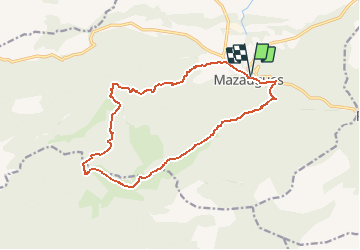
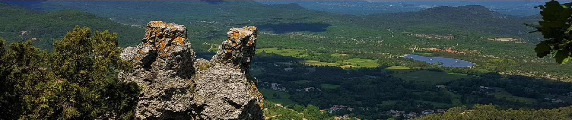
Ruta Senderismo de 16,7 km a descubrir en Provenza-Alpes-Costa Azul, Var, Mazaugues. Esta ruta ha sido propuesta por Greg813.
Descripción
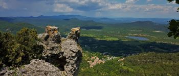
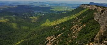
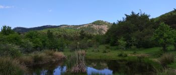
Randonnée au coeur de la forêt domaniale de Mazaugues. L'ascension initiale permet de profiter d'une superbe vue sur toute la vallée.
Localización
País:
France
Región :
Provenza-Alpes-Costa Azul
Departamento/provincia :
Var
Municipio :
Mazaugues
Localidad:
Unknown
Salida:(Dec)
Salida:(UTM)
736880 ; 4803613 (31T) N.
Comentarios
Excursiones cerca
![Excursión Senderismo Tourves - SityTrail - Tourves- Le Saut du Cabri - Les gorges du Caramy - Photo](https://media.geolcdn.com/t/375/260/ext.jpg?maxdim=2&url=https%3A%2F%2Fmedia.geolcdn.com%2Ff%2F124cbbf2-932c-4737-ad3d-4f1fc25db1d8.jpg)
![Senderismo Senderismo](https://static1.geolcdn.com/sitytour/trail-icons/101.png)
SityTrail - Tourves- Le Saut du Cabri - Les gorges du Caramy
Senderismo
Medio
(1)
Tourves,
Provenza-Alpes-Costa Azul,
Var,
France
![](/images/other/stat-length.png)
12,6 km | 17,6 km-effort
6h 0min
![](https://static1.geolcdn.com/siteimages/upload/files/16400158638029165_repeat_loop_refresh_sync_direction_icon.png)
Sí
![Excursión Senderismo La Roquebrussanne - SityTrail - 2718180 - baume-fere-font-coulette-croix-de-berard - Photo](https://media.geolcdn.com/t/375/260/ext.jpg?maxdim=2&url=https%3A%2F%2Fmedia.geolcdn.com%2Ff%2Fc19c381a-d852-4d85-81bc-d0bf63742810.jpg)
![Senderismo Senderismo](https://static1.geolcdn.com/sitytour/trail-icons/101.png)
SityTrail - 2718180 - baume-fere-font-coulette-croix-de-berard
Senderismo
Medio
La Roquebrussanne,
Provenza-Alpes-Costa Azul,
Var,
France
![](/images/other/stat-length.png)
14,4 km | 22 km-effort
6h 0min
![](https://static1.geolcdn.com/siteimages/upload/files/16400158638029165_repeat_loop_refresh_sync_direction_icon.png)
Sí
![Excursión Senderismo Mazaugues - le Mourre d'Agnis au départ du Caucadis - Photo](https://media.geolcdn.com/t/375/260/ext.jpg?maxdim=2&url=https%3A%2F%2Fmedia.geolcdn.com%2Ff%2Fdcd1794e-c5af-44e1-af91-1fadcb296c68.jpg)
![Senderismo Senderismo](https://static1.geolcdn.com/sitytour/trail-icons/101.png)
le Mourre d'Agnis au départ du Caucadis
Senderismo
Difícil
Mazaugues,
Provenza-Alpes-Costa Azul,
Var,
France
![](/images/other/stat-length.png)
17,6 km | 27 km-effort
7h 8min
![](https://static1.geolcdn.com/siteimages/upload/files/16400158638029165_repeat_loop_refresh_sync_direction_icon.png)
Sí
![Excursión Senderismo Mazaugues - Mazaugues le vallon de l'Herbette - Photo](https://media.geolcdn.com/t/375/260/ext.jpg?maxdim=2&url=https%3A%2F%2Fmedia.geolcdn.com%2Ff%2F62c4707c-a050-47d0-822e-64a046e156e1.jpg)
![Senderismo Senderismo](https://static1.geolcdn.com/sitytour/trail-icons/101.png)
Mazaugues le vallon de l'Herbette
Senderismo
Medio
(2)
Mazaugues,
Provenza-Alpes-Costa Azul,
Var,
France
![](/images/other/stat-length.png)
12,2 km | 18,8 km-effort
7h 27min
![](https://static1.geolcdn.com/siteimages/upload/files/16400158638029165_repeat_loop_refresh_sync_direction_icon.png)
Sí
![Excursión Senderismo La Roquebrussanne - la montagne de la Loube - Photo](https://media.geolcdn.com/t/375/260/ext.jpg?maxdim=2&url=https%3A%2F%2Fmedia.geolcdn.com%2Ff%2Fba5f3ad3-4eed-4285-a8f8-9cedf60e39f2.jpg)
![Senderismo Senderismo](https://static1.geolcdn.com/sitytour/trail-icons/101.png)
la montagne de la Loube
Senderismo
Medio
La Roquebrussanne,
Provenza-Alpes-Costa Azul,
Var,
France
![](/images/other/stat-length.png)
13,5 km | 21 km-effort
5h 30min
![](https://static1.geolcdn.com/siteimages/upload/files/16400158638029165_repeat_loop_refresh_sync_direction_icon.png)
Sí
![Excursión Senderismo Tourves - chapelle Saint Probace et gorges du caramy - Photo](https://media.geolcdn.com/t/375/260/ext.jpg?maxdim=2&url=https%3A%2F%2Fservices.sitytrail.com%2FGeolivesWS%2FDownloadMedia.ashx%3FTrailID%3D984279%26Media%3Dfix__20180610150603.jpg)
![Senderismo Senderismo](https://static1.geolcdn.com/sitytour/trail-icons/101.png)
chapelle Saint Probace et gorges du caramy
Senderismo
Fácil
Tourves,
Provenza-Alpes-Costa Azul,
Var,
France
![](/images/other/stat-length.png)
7,7 km | 11,2 km-effort
3h 26min
![](https://static1.geolcdn.com/siteimages/upload/files/16400158638029165_repeat_loop_refresh_sync_direction_icon.png)
Sí
![Excursión Senderismo La Roquebrussanne - La Roquebrussane-Jas du murier - Photo](https://media.geolcdn.com/t/375/260/ext.jpg?maxdim=2&url=https%3A%2F%2Fstatic1.geolcdn.com%2Fsiteimages%2Fupload%2Ffiles%2F1553511878bg_sport_marche.png)
![Senderismo Senderismo](https://static1.geolcdn.com/sitytour/trail-icons/101.png)
La Roquebrussane-Jas du murier
Senderismo
Medio
(1)
La Roquebrussanne,
Provenza-Alpes-Costa Azul,
Var,
France
![](/images/other/stat-length.png)
18,4 km | 25 km-effort
5h 21min
![](https://static1.geolcdn.com/siteimages/upload/files/16400158638029165_repeat_loop_refresh_sync_direction_icon.png)
Sí
![Excursión Senderismo Mazaugues - De Mazaugues vers la glacière Pivaut - Photo](https://media.geolcdn.com/t/375/260/ext.jpg?maxdim=2&url=https%3A%2F%2Fmedia.geolcdn.com%2Ff%2F93cdb635-dd33-4fbf-b53a-783eebba00a2.jpg)
![Senderismo Senderismo](https://static1.geolcdn.com/sitytour/trail-icons/101.png)
De Mazaugues vers la glacière Pivaut
Senderismo
Muy difícil
Mazaugues,
Provenza-Alpes-Costa Azul,
Var,
France
![](/images/other/stat-length.png)
22 km | 30 km-effort
7h 1min
![](https://static1.geolcdn.com/siteimages/upload/files/16400158638029165_repeat_loop_refresh_sync_direction_icon.png)
Sí
![Excursión Senderismo La Roquebrussanne - La Loube 28-02-2024 - Photo](https://media.geolcdn.com/t/375/260/ext.jpg?maxdim=2&url=https%3A%2F%2Fmedia.geolcdn.com%2Ff%2F09cd8076-f0cf-4264-941a-e02f3483f652.jpg)
![Senderismo Senderismo](https://static1.geolcdn.com/sitytour/trail-icons/101.png)
La Loube 28-02-2024
Senderismo
Medio
La Roquebrussanne,
Provenza-Alpes-Costa Azul,
Var,
France
![](/images/other/stat-length.png)
18 km | 27 km-effort
7h 58min
![](https://static1.geolcdn.com/siteimages/upload/files/16400158638029165_repeat_loop_refresh_sync_direction_icon.png)
Sí