![](/images/other/stat-length.png)
![Excursión Senderismo Odeceixe - Boucle de la plage d'Odeceixe - Photo](https://media.geolcdn.com/t/1900/400/ext.pjpeg?maxdim=2&url=https%3A%2F%2Fstatic1.geolcdn.com%2Fsiteimages%2Fupload%2Ffiles%2F1553511878bg_sport_marche.png)
Boucle de la plage d'Odeceixe
rigol05
Usuario
![Longitud](/images/other/stat-length.png)
Longitud
14,6 km
![Altitud máxima](https://static1.geolcdn.com/siteimages/upload/files/1508320355ic_sort_altitude_max_24dp.png)
Altitud máxima
97 m
![Desnivel positivo](https://static1.geolcdn.com/siteimages/upload/files/1508320355ic_sort_den_pos_24dp.png)
Desnivel positivo
240 m
![Km-Effort](/images/other/stat-length.png)
Km-Effort
17,8 km
![Altitud mínima](https://static1.geolcdn.com/siteimages/upload/files/1508320355ic_sort_altitude_min_24dp.png)
Altitud mínima
0 m
![Desnivel negativo](https://static1.geolcdn.com/siteimages/upload/files/1508320355ic_sort_den_neg_24dp.png)
Desnivel negativo
240 m
![Boucle](https://static1.geolcdn.com/siteimages/upload/files/16400158638029165_repeat_loop_refresh_sync_direction_icon.png)
Boucle
Sí
Fecha de creación :
2018-06-26 14:12:28.455
Última modificación :
2018-06-26 14:12:28.455
![Senderismo](https://static1.geolcdn.com/sitytour/trail-icons/101.png)
3h55
Dificultad : Medio
![Escanee este código QR para abrir la excursión en la aplicación SityTrail](https://capi.geolives.com/qq0zvz2zws4bq2lad0pu/sitytour/trails/968181/qr.png?size=200)
Aplicación GPS de excursión GRATIS
A propósito
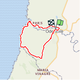
Ruta Senderismo de 14,6 km a descubrir en Algarve, Faro, Odeceixe. Esta ruta ha sido propuesta por rigol05.
Descripción
Sortie du 17/05/2018 Départ Odeceixe. Monter vers le moulin, puis suivre le canal d'irrigation.Bifurquer Ouest pour rejoindre le sentier des pêcheurs.Des couleurs,des odeurs des paysages,très beau circuit.
Localización
País:
Portugal
Región :
Algarve
Departamento/provincia :
Faro
Municipio :
Odeceixe
Localidad:
Unknown
Salida:(Dec)
Salida:(UTM)
520452 ; 4143108 (29S) N.
Comentarios
Excursiones cerca
![Excursión Senderismo Odeceixe - Odeceixe - Aljazur 5 - Photo](https://media.geolcdn.com/t/375/260/ext.jpg?maxdim=2&url=https%3A%2F%2Fstatic1.geolcdn.com%2Fsiteimages%2Fupload%2Ffiles%2F1553511878bg_sport_marche.png)
![Senderismo Senderismo](https://static1.geolcdn.com/sitytour/trail-icons/101.png)
Odeceixe - Aljazur 5
Senderismo
Fácil
Odeceixe,
Algarve,
Faro,
Portugal
![](/images/other/stat-length.png)
17,9 km | 20 km-effort
4h 28min
![](https://static1.geolcdn.com/siteimages/upload/files/16400158638029165_repeat_loop_refresh_sync_direction_icon.png)
No
![Excursión Senderismo Odeceixe - Poutougal J6 - Photo](https://media.geolcdn.com/t/375/260/ext.jpg?maxdim=2&url=https%3A%2F%2Fstatic1.geolcdn.com%2Fsiteimages%2Fupload%2Ffiles%2F1553511878bg_sport_marche.png)
![Senderismo Senderismo](https://static1.geolcdn.com/sitytour/trail-icons/101.png)
![Excursión Senderismo São Teotónio - Enigma 3 - Photo](https://media.geolcdn.com/t/375/260/ext.jpg?maxdim=2&url=https%3A%2F%2Fstatic1.geolcdn.com%2Fsiteimages%2Fupload%2Ffiles%2F1553511878bg_sport_marche.png)
![Senderismo Senderismo](https://static1.geolcdn.com/sitytour/trail-icons/101.png)
Enigma 3
Senderismo
Medio
São Teotónio,
Alentejo,
Beja,
Portugal
![](/images/other/stat-length.png)
11,8 km | 15,1 km-effort
2h 9min
![](https://static1.geolcdn.com/siteimages/upload/files/16400158638029165_repeat_loop_refresh_sync_direction_icon.png)
Sí
![Excursión Senderismo São Teotónio - Enigma 2 - Photo](https://media.geolcdn.com/t/375/260/ext.jpg?maxdim=2&url=https%3A%2F%2Fstatic1.geolcdn.com%2Fsiteimages%2Fupload%2Ffiles%2F1553511878bg_sport_marche.png)
![Senderismo Senderismo](https://static1.geolcdn.com/sitytour/trail-icons/101.png)
Enigma 2
Senderismo
Medio
São Teotónio,
Alentejo,
Beja,
Portugal
![](/images/other/stat-length.png)
11,5 km | 14,6 km-effort
2h 5min
![](https://static1.geolcdn.com/siteimages/upload/files/16400158638029165_repeat_loop_refresh_sync_direction_icon.png)
Sí
![Excursión Senderismo São Teotónio - Enigma - Azenha do mar - Photo](https://media.geolcdn.com/t/375/260/ext.jpg?maxdim=2&url=https%3A%2F%2Fstatic1.geolcdn.com%2Fsiteimages%2Fupload%2Ffiles%2F1553511878bg_sport_marche.png)
![Senderismo Senderismo](https://static1.geolcdn.com/sitytour/trail-icons/101.png)
Enigma - Azenha do mar
Senderismo
Fácil
São Teotónio,
Alentejo,
Beja,
Portugal
![](/images/other/stat-length.png)
15,6 km | 17,8 km-effort
3h 0min
![](https://static1.geolcdn.com/siteimages/upload/files/16400158638029165_repeat_loop_refresh_sync_direction_icon.png)
Sí
![Excursión Senderismo Odeceixe - odeceixe - aljezur - Photo](https://media.geolcdn.com/t/375/260/ext.jpg?maxdim=2&url=https%3A%2F%2Fstatic1.geolcdn.com%2Fsiteimages%2Fupload%2Ffiles%2F1553511878bg_sport_marche.png)
![Senderismo Senderismo](https://static1.geolcdn.com/sitytour/trail-icons/101.png)
odeceixe - aljezur
Senderismo
Muy fácil
Odeceixe,
Algarve,
Faro,
Portugal
![](/images/other/stat-length.png)
21 km | 23 km-effort
6h 14min
![](https://static1.geolcdn.com/siteimages/upload/files/16400158638029165_repeat_loop_refresh_sync_direction_icon.png)
No
![Excursión Senderismo Odeceixe - A - Odeceixe - Aljesur 18 Km - Photo](https://media.geolcdn.com/t/375/260/ext.jpg?maxdim=2&url=https%3A%2F%2Fstatic1.geolcdn.com%2Fsiteimages%2Fupload%2Ffiles%2F1553511878bg_sport_marche.png)
![Senderismo Senderismo](https://static1.geolcdn.com/sitytour/trail-icons/101.png)
A - Odeceixe - Aljesur 18 Km
Senderismo
Medio
Odeceixe,
Algarve,
Faro,
Portugal
![](/images/other/stat-length.png)
17,9 km | 20 km-effort
4h 28min
![](https://static1.geolcdn.com/siteimages/upload/files/16400158638029165_repeat_loop_refresh_sync_direction_icon.png)
No
![Excursión Senderismo Odeceixe - B - Odeceixe - 13 Km - Photo](https://media.geolcdn.com/t/375/260/ext.jpg?maxdim=2&url=https%3A%2F%2Fstatic1.geolcdn.com%2Fsiteimages%2Fupload%2Ffiles%2F1553511878bg_sport_marche.png)
![Senderismo Senderismo](https://static1.geolcdn.com/sitytour/trail-icons/101.png)
B - Odeceixe - 13 Km
Senderismo
Medio
Odeceixe,
Algarve,
Faro,
Portugal
![](/images/other/stat-length.png)
13 km | 15,4 km-effort
3h 28min
![](https://static1.geolcdn.com/siteimages/upload/files/16400158638029165_repeat_loop_refresh_sync_direction_icon.png)
Sí
![Excursión Otra actividad Odeceixe - autour de Praia de odeceixe - Photo](https://media.geolcdn.com/t/375/260/ext.jpg?maxdim=2&url=https%3A%2F%2Fstatic1.geolcdn.com%2Fsiteimages%2Fupload%2Ffiles%2F1545311037marcheuse_200dpi.jpg)
![Otra actividad Otra actividad](https://static1.geolcdn.com/sitytour/trail-icons/900.png)
autour de Praia de odeceixe
Otra actividad
Muy fácil
Odeceixe,
Algarve,
Faro,
Portugal
![](/images/other/stat-length.png)
15,7 km | 18,6 km-effort
4h 34min
![](https://static1.geolcdn.com/siteimages/upload/files/16400158638029165_repeat_loop_refresh_sync_direction_icon.png)
Sí