![](/images/other/stat-length.png)
![Excursión Senderismo Châtelus - pas de l'allier - Photo](https://media.geolcdn.com/t/1900/400/ext.pjpeg?maxdim=2&url=https%3A%2F%2Fstatic1.geolcdn.com%2Fsiteimages%2Fupload%2Ffiles%2F1553511878bg_sport_marche.png)
pas de l'allier
guyzinz
Usuario
![Longitud](/images/other/stat-length.png)
Longitud
17,5 km
![Altitud máxima](https://static1.geolcdn.com/siteimages/upload/files/1508320355ic_sort_altitude_max_24dp.png)
Altitud máxima
1279 m
![Desnivel positivo](https://static1.geolcdn.com/siteimages/upload/files/1508320355ic_sort_den_pos_24dp.png)
Desnivel positivo
1152 m
![Km-Effort](/images/other/stat-length.png)
Km-Effort
33 km
![Altitud mínima](https://static1.geolcdn.com/siteimages/upload/files/1508320355ic_sort_altitude_min_24dp.png)
Altitud mínima
306 m
![Desnivel negativo](https://static1.geolcdn.com/siteimages/upload/files/1508320355ic_sort_den_neg_24dp.png)
Desnivel negativo
1170 m
![Boucle](https://static1.geolcdn.com/siteimages/upload/files/16400158638029165_repeat_loop_refresh_sync_direction_icon.png)
Boucle
Sí
Fecha de creación :
2019-06-07 09:39:03.65
Última modificación :
2019-06-07 09:39:03.97
![Senderismo](https://static1.geolcdn.com/sitytour/trail-icons/101.png)
6h54
Dificultad : Desconocido
![Escanee este código QR para abrir la excursión en la aplicación SityTrail](https://capi.geolives.com/qq0zvz2zws4bq2lad0pu/sitytour/trails/959795/qr.png?size=200)
Aplicación GPS de excursión GRATIS
A propósito
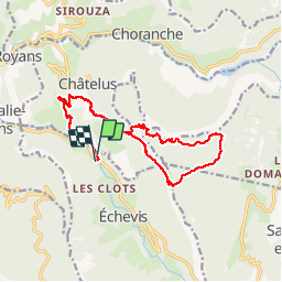
Ruta Senderismo de 17,5 km a descubrir en Auvergne-Rhône-Alpes, Isère, Châtelus. Esta ruta ha sido propuesta por guyzinz.
Descripción
depart "pont d'echevis" montée vers mezelier pas des voutes rochers du bournillon pas de l'allier retour sur pont d'echevis en passant par mezelier
Localización
País:
France
Región :
Auvergne-Rhône-Alpes
Departamento/provincia :
Isère
Municipio :
Châtelus
Localidad:
Unknown
Salida:(Dec)
Salida:(UTM)
687161 ; 4990169 (31T) N.
Comentarios
Excursiones cerca
![Excursión Senderismo La Chapelle-en-Vercors - Belvedere de la Révoulat - Photo](https://media.geolcdn.com/t/375/260/ext.jpg?maxdim=2&url=https%3A%2F%2Fservices.sitytrail.com%2FGeolivesWS%2FDownloadMedia.ashx%3FTrailID%3D190649%26Media%3Dbea7fca0-eae7-4bcb-a9b2-0754c6f93b9f.JPG)
![Senderismo Senderismo](https://static1.geolcdn.com/sitytour/trail-icons/101.png)
Belvedere de la Révoulat
Senderismo
Fácil
(1)
La Chapelle-en-Vercors,
Auvergne-Rhône-Alpes,
Drôme,
France
![](/images/other/stat-length.png)
5,3 km | 10,6 km-effort
2h 5min
![](https://static1.geolcdn.com/siteimages/upload/files/16400158638029165_repeat_loop_refresh_sync_direction_icon.png)
Sí
![Excursión Senderismo Châtelus - Boucle Pas de l'Allier - Pas des Voutes - Photo](https://media.geolcdn.com/t/375/260/ext.jpg?maxdim=2&url=https%3A%2F%2Fservices.sitytrail.com%2FGeolivesWS%2FDownloadMedia.ashx%3FTrailID%3D105085%26Media%3D8675_1.jpg)
![Senderismo Senderismo](https://static1.geolcdn.com/sitytour/trail-icons/101.png)
Boucle Pas de l'Allier - Pas des Voutes
Senderismo
Medio
(1)
Châtelus,
Auvergne-Rhône-Alpes,
Isère,
France
![](/images/other/stat-length.png)
10,1 km | 22 km-effort
4h 30min
![](https://static1.geolcdn.com/siteimages/upload/files/16400158638029165_repeat_loop_refresh_sync_direction_icon.png)
Sí
![Excursión Otra actividad Saint-Martin-en-Vercors - Cournouses pas de l'allier - Photo](https://media.geolcdn.com/t/375/260/ext.jpg?maxdim=2&url=https%3A%2F%2Fstatic1.geolcdn.com%2Fsiteimages%2Fupload%2Ffiles%2F1545311037marcheuse_200dpi.jpg)
![Otra actividad Otra actividad](https://static1.geolcdn.com/sitytour/trail-icons/900.png)
Cournouses pas de l'allier
Otra actividad
Medio
(1)
Saint-Martin-en-Vercors,
Auvergne-Rhône-Alpes,
Drôme,
France
![](/images/other/stat-length.png)
11 km | 21 km-effort
5h 0min
![](https://static1.geolcdn.com/siteimages/upload/files/16400158638029165_repeat_loop_refresh_sync_direction_icon.png)
Sí
![Excursión Senderismo Choranche - La Grotte de Choranche - Photo](https://media.geolcdn.com/t/375/260/ext.jpg?maxdim=2&url=https%3A%2F%2Fstatic1.geolcdn.com%2Fsiteimages%2Fupload%2Ffiles%2F1553511878bg_sport_marche.png)
![Senderismo Senderismo](https://static1.geolcdn.com/sitytour/trail-icons/101.png)
La Grotte de Choranche
Senderismo
Difícil
(1)
Choranche,
Auvergne-Rhône-Alpes,
Isère,
France
![](/images/other/stat-length.png)
17,8 km | 33 km-effort
7h 6min
![](https://static1.geolcdn.com/siteimages/upload/files/16400158638029165_repeat_loop_refresh_sync_direction_icon.png)
Sí
![Excursión sport Saint-Laurent-en-Royans - St Laurent en Royans. La Laurentine - Photo](https://media.geolcdn.com/t/375/260/ext.jpg?maxdim=2&url=https%3A%2F%2Fmedia.geolcdn.com%2Ff%2F19b70eea-b54e-4263-823b-d99859d9e399.jpg)
St Laurent en Royans. La Laurentine
sport
Muy fácil
Saint-Laurent-en-Royans,
Auvergne-Rhône-Alpes,
Drôme,
France
![](/images/other/stat-length.png)
16,3 km | 27 km-effort
Desconocido
![](https://static1.geolcdn.com/siteimages/upload/files/16400158638029165_repeat_loop_refresh_sync_direction_icon.png)
Sí
![Excursión Senderismo Saint-Laurent-en-Royans - 26 rocher des mines ARP - Photo](https://media.geolcdn.com/t/375/260/ext.jpg?maxdim=2&url=https%3A%2F%2Fmedia.geolcdn.com%2Ff%2Fbd4f581f-b362-467f-a5ca-afa55317a017.jpg)
![Senderismo Senderismo](https://static1.geolcdn.com/sitytour/trail-icons/101.png)
26 rocher des mines ARP
Senderismo
Muy difícil
Saint-Laurent-en-Royans,
Auvergne-Rhône-Alpes,
Drôme,
France
![](/images/other/stat-length.png)
8,6 km | 16,2 km-effort
6h 53min
![](https://static1.geolcdn.com/siteimages/upload/files/16400158638029165_repeat_loop_refresh_sync_direction_icon.png)
Sí
![Excursión Senderismo Sainte-Eulalie-en-Royans - 26 ste eulalie - Photo](https://media.geolcdn.com/t/375/260/ext.jpg?maxdim=2&url=https%3A%2F%2Fmedia.geolcdn.com%2Ff%2Fcc17d7c1-039b-4811-aa20-433bfbe37107.jpg)
![Senderismo Senderismo](https://static1.geolcdn.com/sitytour/trail-icons/101.png)
26 ste eulalie
Senderismo
Medio
Sainte-Eulalie-en-Royans,
Auvergne-Rhône-Alpes,
Drôme,
France
![](/images/other/stat-length.png)
14,8 km | 27 km-effort
6h 43min
![](https://static1.geolcdn.com/siteimages/upload/files/16400158638029165_repeat_loop_refresh_sync_direction_icon.png)
No
![Excursión Senderismo Châtelus - 38 pabro charmatte - Photo](https://media.geolcdn.com/t/375/260/ext.jpg?maxdim=2&url=https%3A%2F%2Fmedia.geolcdn.com%2Ff%2F983fca8d-ac95-4180-878f-eb8932bd4279.jpg)
![Senderismo Senderismo](https://static1.geolcdn.com/sitytour/trail-icons/101.png)
38 pabro charmatte
Senderismo
Difícil
Châtelus,
Auvergne-Rhône-Alpes,
Isère,
France
![](/images/other/stat-length.png)
11,4 km | 29 km-effort
7h 43min
![](https://static1.geolcdn.com/siteimages/upload/files/16400158638029165_repeat_loop_refresh_sync_direction_icon.png)
Sí
![Excursión Marcha nórdica Saint-Laurent-en-Royans - Circuit entre Saint-Laurent-en-Royans et Pont-en-Royans - Photo](https://media.geolcdn.com/t/375/260/ext.jpg?maxdim=2&url=https%3A%2F%2Fmedia.geolcdn.com%2Ff%2Fe35cab6e-ed35-4b24-b3a9-4e25ca3d2169.jpg)
![Marcha nórdica Marcha nórdica](https://static1.geolcdn.com/sitytour/trail-icons/102.png)
Circuit entre Saint-Laurent-en-Royans et Pont-en-Royans
Marcha nórdica
Medio
Saint-Laurent-en-Royans,
Auvergne-Rhône-Alpes,
Drôme,
France
![](/images/other/stat-length.png)
13 km | 17,4 km-effort
5h 9min
![](https://static1.geolcdn.com/siteimages/upload/files/16400158638029165_repeat_loop_refresh_sync_direction_icon.png)
Sí