![](/images/other/stat-length.png)
![Excursión Otra actividad Thérondels - Therondels à Pierrefort - Photo](https://media.geolcdn.com/t/1900/400/ext.pjpeg?maxdim=2&url=https%3A%2F%2Fstatic1.geolcdn.com%2Fsiteimages%2Fupload%2Ffiles%2F1545311037marcheuse_200dpi.jpg)
Therondels à Pierrefort
paul12
Usuario
![Longitud](/images/other/stat-length.png)
Longitud
12,3 km
![Altitud máxima](https://static1.geolcdn.com/siteimages/upload/files/1508320355ic_sort_altitude_max_24dp.png)
Altitud máxima
994 m
![Desnivel positivo](https://static1.geolcdn.com/siteimages/upload/files/1508320355ic_sort_den_pos_24dp.png)
Desnivel positivo
391 m
![Km-Effort](/images/other/stat-length.png)
Km-Effort
17,6 km
![Altitud mínima](https://static1.geolcdn.com/siteimages/upload/files/1508320355ic_sort_altitude_min_24dp.png)
Altitud mínima
673 m
![Desnivel negativo](https://static1.geolcdn.com/siteimages/upload/files/1508320355ic_sort_den_neg_24dp.png)
Desnivel negativo
414 m
![Boucle](https://static1.geolcdn.com/siteimages/upload/files/16400158638029165_repeat_loop_refresh_sync_direction_icon.png)
Boucle
No
Fecha de creación :
2018-06-26 13:14:51.689
Última modificación :
2018-06-26 13:14:51.689
![Otra actividad](https://static1.geolcdn.com/sitytour/trail-icons/900.png)
4h21
Dificultad : Medio
![Escanee este código QR para abrir la excursión en la aplicación SityTrail](https://capi.geolives.com/qq0zvz2zws4bq2lad0pu/sitytour/trails/958802/qr.png?size=200)
Aplicación GPS de excursión GRATIS
A propósito
Ruta Otra actividad de 12,3 km a descubrir en Occitania, Aveyron, Thérondels. Esta ruta ha sido propuesta por paul12.
Descripción
Un départ à 950 m le passage du pont d estradié à 650 m environ.un parcours en chemin creux ou piste agricole avec une belle flore des haies et avec un peu de chance la vue d un chevreuil.
Localización
País:
France
Región :
Occitania
Departamento/provincia :
Aveyron
Municipio :
Thérondels
Localidad:
Unknown
Salida:(Dec)
Salida:(UTM)
481077 ; 4971181 (31T) N.
Comentarios
Excursiones cerca
![Excursión Senderismo Thérondels - Thérondels,Nigresserre - Photo](https://media.geolcdn.com/t/375/260/ext.jpg?maxdim=2&url=https%3A%2F%2Fstatic1.geolcdn.com%2Fsiteimages%2Fupload%2Ffiles%2F1553511878bg_sport_marche.png)
![Senderismo Senderismo](https://static1.geolcdn.com/sitytour/trail-icons/101.png)
Thérondels,Nigresserre
Senderismo
Fácil
(1)
Thérondels,
Occitania,
Aveyron,
France
![](/images/other/stat-length.png)
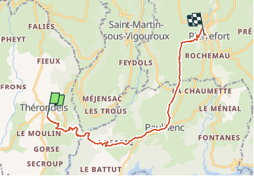
12,7 km | 14,8 km-effort
3h 14min
![](https://static1.geolcdn.com/siteimages/upload/files/16400158638029165_repeat_loop_refresh_sync_direction_icon.png)
No
![Excursión Senderismo Thérondels - Balade à la presqu''ile de Laussac - Thérondels - Photo](https://media.geolcdn.com/t/375/260/ext.jpg?maxdim=2&url=https%3A%2F%2Fservices.sitytrail.com%2FGeolivesWS%2FDownloadMedia.ashx%3FTrailID%3D215284%26Media%3D15681_4.jpg)
![Senderismo Senderismo](https://static1.geolcdn.com/sitytour/trail-icons/101.png)
Balade à la presqu''ile de Laussac - Thérondels
Senderismo
Difícil
(1)
Thérondels,
Occitania,
Aveyron,
France
![](/images/other/stat-length.png)
17,1 km | 24 km-effort
6h 0min
![](https://static1.geolcdn.com/siteimages/upload/files/16400158638029165_repeat_loop_refresh_sync_direction_icon.png)
Sí
![Excursión Senderismo Lacapelle-Barrès - puy de Bane - Photo](https://media.geolcdn.com/t/375/260/ext.jpg?maxdim=2&url=https%3A%2F%2Fstatic1.geolcdn.com%2Fsiteimages%2Fupload%2Ffiles%2F1553511878bg_sport_marche.png)
![Senderismo Senderismo](https://static1.geolcdn.com/sitytour/trail-icons/101.png)
puy de Bane
Senderismo
Difícil
Lacapelle-Barrès,
Auvergne-Rhône-Alpes,
Cantal,
France
![](/images/other/stat-length.png)
19,2 km | 26 km-effort
4h 3min
![](https://static1.geolcdn.com/siteimages/upload/files/16400158638029165_repeat_loop_refresh_sync_direction_icon.png)
Sí
![Excursión Senderismo Thérondels - Therondels - Photo](https://media.geolcdn.com/t/375/260/37252885-c645-44e6-a317-8d8420defd3d.jpg&format=jpg&maxdim=2)
![Senderismo Senderismo](https://static1.geolcdn.com/sitytour/trail-icons/101.png)
Therondels
Senderismo
Medio
Thérondels,
Occitania,
Aveyron,
France
![](/images/other/stat-length.png)
15,9 km | 22 km-effort
3h 14min
![](https://static1.geolcdn.com/siteimages/upload/files/16400158638029165_repeat_loop_refresh_sync_direction_icon.png)
Sí
![Excursión Senderismo Paulhenc - tersons 13b - Photo](https://media.geolcdn.com/t/375/260/ext.jpg?maxdim=2&url=https%3A%2F%2Fstatic1.geolcdn.com%2Fsiteimages%2Fupload%2Ffiles%2F1553511878bg_sport_marche.png)
![Senderismo Senderismo](https://static1.geolcdn.com/sitytour/trail-icons/101.png)
tersons 13b
Senderismo
Muy fácil
Paulhenc,
Auvergne-Rhône-Alpes,
Cantal,
France
![](/images/other/stat-length.png)
11,4 km | 13,7 km-effort
3h 9min
![](https://static1.geolcdn.com/siteimages/upload/files/16400158638029165_repeat_loop_refresh_sync_direction_icon.png)
No
![Excursión Senderismo Thérondels - THÉRONDELS _ et le paysan créa la prairie 2) - Photo](https://media.geolcdn.com/t/375/260/ext.jpg?maxdim=2&url=https%3A%2F%2Fstatic1.geolcdn.com%2Fsiteimages%2Fupload%2Ffiles%2F1553511878bg_sport_marche.png)
![Senderismo Senderismo](https://static1.geolcdn.com/sitytour/trail-icons/101.png)
THÉRONDELS _ et le paysan créa la prairie 2)
Senderismo
Muy fácil
(1)
Thérondels,
Occitania,
Aveyron,
France
![](/images/other/stat-length.png)
4,1 km | 4,8 km-effort
1h 30min
![](https://static1.geolcdn.com/siteimages/upload/files/16400158638029165_repeat_loop_refresh_sync_direction_icon.png)
Sí
![Excursión Senderismo Paulhenc - la garde-estradié - Photo](https://media.geolcdn.com/t/375/260/ext.jpg?maxdim=2&url=https%3A%2F%2Fstatic1.geolcdn.com%2Fsiteimages%2Fupload%2Ffiles%2F1553511878bg_sport_marche.png)
![Senderismo Senderismo](https://static1.geolcdn.com/sitytour/trail-icons/101.png)
la garde-estradié
Senderismo
Fácil
Paulhenc,
Auvergne-Rhône-Alpes,
Cantal,
France
![](/images/other/stat-length.png)
2,8 km | 3,6 km-effort
59min
![](https://static1.geolcdn.com/siteimages/upload/files/16400158638029165_repeat_loop_refresh_sync_direction_icon.png)
No
![Excursión Senderismo Thérondels - Sentier imaginaire court Therondels - Photo](https://media.geolcdn.com/t/375/260/ext.jpg?maxdim=2&url=https%3A%2F%2Fstatic1.geolcdn.com%2Fsiteimages%2Fupload%2Ffiles%2F1553511878bg_sport_marche.png)
![Senderismo Senderismo](https://static1.geolcdn.com/sitytour/trail-icons/101.png)
Sentier imaginaire court Therondels
Senderismo
Fácil
Thérondels,
Occitania,
Aveyron,
France
![](/images/other/stat-length.png)
3,6 km | 3,9 km-effort
1h 11min
![](https://static1.geolcdn.com/siteimages/upload/files/16400158638029165_repeat_loop_refresh_sync_direction_icon.png)
Sí
![Excursión Senderismo Cantoin - Vines les berges du lac de Sarrans - Photo](https://media.geolcdn.com/t/375/260/ext.jpg?maxdim=2&url=https%3A%2F%2Fstatic1.geolcdn.com%2Fsiteimages%2Fupload%2Ffiles%2F1553511878bg_sport_marche.png)
![Senderismo Senderismo](https://static1.geolcdn.com/sitytour/trail-icons/101.png)
Vines les berges du lac de Sarrans
Senderismo
Difícil
(1)
Cantoin,
Occitania,
Aveyron,
France
![](/images/other/stat-length.png)
11,2 km | 16,4 km-effort
3h 43min
![](https://static1.geolcdn.com/siteimages/upload/files/16400158638029165_repeat_loop_refresh_sync_direction_icon.png)
Sí