![](/images/other/stat-length.png)
![Excursión Senderismo Aspach-Michelbach - 2018 05 03 Michelbach - Rammersmatt - Photo](https://media.geolcdn.com/t/1900/400/ext.pjpeg?maxdim=2&url=https%3A%2F%2Fstatic1.geolcdn.com%2Fsiteimages%2Fupload%2Ffiles%2F1553511878bg_sport_marche.png)
2018 05 03 Michelbach - Rammersmatt
E.BURCK
Usuario
![Longitud](/images/other/stat-length.png)
![Altitud máxima](https://static1.geolcdn.com/siteimages/upload/files/1508320355ic_sort_altitude_max_24dp.png)
![Desnivel positivo](https://static1.geolcdn.com/siteimages/upload/files/1508320355ic_sort_den_pos_24dp.png)
![Km-Effort](/images/other/stat-length.png)
![Altitud mínima](https://static1.geolcdn.com/siteimages/upload/files/1508320355ic_sort_altitude_min_24dp.png)
![Desnivel negativo](https://static1.geolcdn.com/siteimages/upload/files/1508320355ic_sort_den_neg_24dp.png)
![Boucle](https://static1.geolcdn.com/siteimages/upload/files/16400158638029165_repeat_loop_refresh_sync_direction_icon.png)
![Senderismo](https://static1.geolcdn.com/sitytour/trail-icons/101.png)
3h47
Dificultad : Medio
![Escanee este código QR para abrir la excursión en la aplicación SityTrail](https://capi.geolives.com/qq0zvz2zws4bq2lad0pu/sitytour/trails/955535/qr.png?size=200)
Aplicación GPS de excursión GRATIS
A propósito
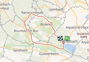
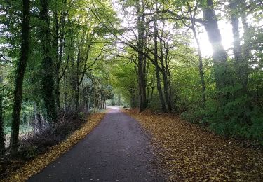
Ruta Senderismo de 13,6 km a descubrir en Gran Este, Alto Rin, Aspach-Michelbach. Esta ruta ha sido propuesta por E.BURCK.
Descripción
ACCÈS :
Par Aspach le Haut puis Michelbach.
PARKING:
Parking du cimetière au niveau du 12 rue principale Michelbach.
47.760872 7.113891
N 47°45'39" E 07°06'50"
RESTAURATION :
Restaurant aux 3 sapins à Rammersmatt.
Tél. 03 89 37 20 39
Localización
Comentarios
Excursiones cerca
![Excursión Senderismo Sentheim - Sentheim Rossberg - Photo](https://media.geolcdn.com/t/375/260/a036ff16-f534-44a4-ad7d-39598edf8c1e.jpg&format=jpg&maxdim=2)
![Senderismo Senderismo](https://static1.geolcdn.com/sitytour/trail-icons/101.png)
Senderismo
![](/images/other/stat-length.png)
![](https://static1.geolcdn.com/siteimages/upload/files/16400158638029165_repeat_loop_refresh_sync_direction_icon.png)
![Excursión A pie Sentheim - Sentier géologique du Wolfloch - Photo](https://media.geolcdn.com/t/375/260/3b31644e-e98b-4e9b-958d-a3c4208c2bbd.jpeg&format=jpg&maxdim=2)
![A pie A pie](https://static1.geolcdn.com/sitytour/trail-icons/100.png)
A pie
![](/images/other/stat-length.png)
![](https://static1.geolcdn.com/siteimages/upload/files/16400158638029165_repeat_loop_refresh_sync_direction_icon.png)
![Excursión Senderismo Sentheim - Randonnée Pentecôte 2024 - Photo](https://media.geolcdn.com/t/375/260/5b01bebc-5c9b-4fee-93d4-97171ac59809.jpg&format=jpg&maxdim=2)
![Senderismo Senderismo](https://static1.geolcdn.com/sitytour/trail-icons/101.png)
Senderismo
![](/images/other/stat-length.png)
![](https://static1.geolcdn.com/siteimages/upload/files/16400158638029165_repeat_loop_refresh_sync_direction_icon.png)
![Excursión Senderismo Sentheim - Knapphutte Saegenkopf Hütte - Photo](https://media.geolcdn.com/t/375/260/40c0149e-a232-4115-bfb0-15079675190f.jpg&format=jpg&maxdim=2)
![Senderismo Senderismo](https://static1.geolcdn.com/sitytour/trail-icons/101.png)
Senderismo
![](/images/other/stat-length.png)
![](https://static1.geolcdn.com/siteimages/upload/files/16400158638029165_repeat_loop_refresh_sync_direction_icon.png)
![Excursión Senderismo Burnhaupt-le-Haut - Rando du 09/02/2024 par Alain...Pont d'Aspach - Photo](https://media.geolcdn.com/t/375/260/8bf78224-a247-4f67-bf02-5b95f58c9fa0.jpg&format=jpg&maxdim=2)
![Senderismo Senderismo](https://static1.geolcdn.com/sitytour/trail-icons/101.png)
Senderismo
![](/images/other/stat-length.png)
![](https://static1.geolcdn.com/siteimages/upload/files/16400158638029165_repeat_loop_refresh_sync_direction_icon.png)
![Excursión Senderismo Sentheim - Montori - Photo](https://media.geolcdn.com/t/375/260/60fb76bf-d069-4a22-ad34-ce9de6b50bcf.jpg&format=jpg&maxdim=2)
![Senderismo Senderismo](https://static1.geolcdn.com/sitytour/trail-icons/101.png)
![Excursión Bici de montaña Sentheim - AperoDioller - Photo](https://media.geolcdn.com/t/375/260/24816b30-31ad-46f8-8596-a3b12e2b004e.jpg&format=jpg&maxdim=2)
![Bici de montaña Bici de montaña](https://static1.geolcdn.com/sitytour/trail-icons/202.png)
Bici de montaña
![](/images/other/stat-length.png)
![](https://static1.geolcdn.com/siteimages/upload/files/16400158638029165_repeat_loop_refresh_sync_direction_icon.png)
![Excursión Senderismo Sentheim - Baerenkopf - Photo](https://media.geolcdn.com/t/375/260/6b8495d2-8858-4f60-b8e9-d949218d0777.jpg&format=jpg&maxdim=2)
![Senderismo Senderismo](https://static1.geolcdn.com/sitytour/trail-icons/101.png)
![Excursión Senderismo Sentheim - Lac Seigneurie Soultzbach - Photo](https://media.geolcdn.com/t/375/260/3cfbaae3-c63e-4112-8e65-d15905061667.jpg&format=jpg&maxdim=2)
![Senderismo Senderismo](https://static1.geolcdn.com/sitytour/trail-icons/101.png)
Senderismo
![](/images/other/stat-length.png)
![](https://static1.geolcdn.com/siteimages/upload/files/16400158638029165_repeat_loop_refresh_sync_direction_icon.png)