![](/images/other/stat-length.png)
![Excursión Senderismo Ruan - Moulins du Robec et Cote Ste CatherineNouveau guide - Photo](https://media.geolcdn.com/t/1900/400/ext.pjpeg?maxdim=2&url=https%3A%2F%2Fstatic1.geolcdn.com%2Fsiteimages%2Fupload%2Ffiles%2F1553511878bg_sport_marche.png)
Moulins du Robec et Cote Ste CatherineNouveau guide
randojj
Usuario
![Longitud](/images/other/stat-length.png)
Longitud
12 km
![Altitud máxima](https://static1.geolcdn.com/siteimages/upload/files/1508320355ic_sort_altitude_max_24dp.png)
Altitud máxima
149 m
![Desnivel positivo](https://static1.geolcdn.com/siteimages/upload/files/1508320355ic_sort_den_pos_24dp.png)
Desnivel positivo
227 m
![Km-Effort](/images/other/stat-length.png)
Km-Effort
15,1 km
![Altitud mínima](https://static1.geolcdn.com/siteimages/upload/files/1508320355ic_sort_altitude_min_24dp.png)
Altitud mínima
7 m
![Desnivel negativo](https://static1.geolcdn.com/siteimages/upload/files/1508320355ic_sort_den_neg_24dp.png)
Desnivel negativo
228 m
![Boucle](https://static1.geolcdn.com/siteimages/upload/files/16400158638029165_repeat_loop_refresh_sync_direction_icon.png)
Boucle
Sí
Fecha de creación :
2019-04-26 07:45:17.064
Última modificación :
2019-04-26 07:45:17.09
![Senderismo](https://static1.geolcdn.com/sitytour/trail-icons/101.png)
3h20
Dificultad : Medio
![Escanee este código QR para abrir la excursión en la aplicación SityTrail](https://capi.geolives.com/qq0zvz2zws4bq2lad0pu/sitytour/trails/945669/qr.png?size=200)
Aplicación GPS de excursión GRATIS
A propósito
Ruta Senderismo de 12 km a descubrir en Normandía, Sena-Marítimo, Ruan. Esta ruta ha sido propuesta por randojj.
Descripción
Départ du parvis de l'église St Hilaire.Revenir vers la place St Hilaire,puis prendre à gauche la rue de l'abreuvoir,derrière la clinique St Hilaire, ou l'on pourra admirer la maison du poète " Roger Gosseaume".
Localización
País:
France
Región :
Normandía
Departamento/provincia :
Sena-Marítimo
Municipio :
Ruan
Localidad:
Unknown
Salida:(Dec)
Salida:(UTM)
363449 ; 5478293 (31U) N.
Comentarios
Excursiones cerca
![Excursión Senderismo Mont-Saint-Aignan - Mont-saint-aignan - Chasse-Marée - - Photo](https://media.geolcdn.com/t/375/260/9cf681a4-2bd4-44f5-95c9-4e27e69bf20e.jpg&format=jpg&maxdim=2)
![Senderismo Senderismo](https://static1.geolcdn.com/sitytour/trail-icons/101.png)
Mont-saint-aignan - Chasse-Marée -
Senderismo
Difícil
(1)
Mont-Saint-Aignan,
Normandía,
Sena-Marítimo,
France
![](/images/other/stat-length.png)
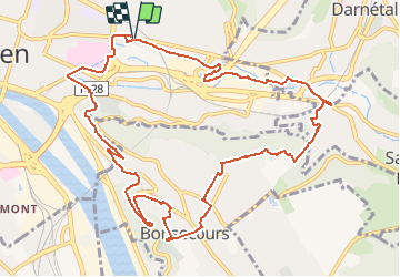
11,7 km | 15,2 km-effort
3h 27min
![](https://static1.geolcdn.com/siteimages/upload/files/16400158638029165_repeat_loop_refresh_sync_direction_icon.png)
Sí
![Senderismo Senderismo](https://static1.geolcdn.com/sitytour/trail-icons/101.png)
076-34-le tour de Darnétal 13km 875-557
Senderismo
Medio
(1)
Darnétal,
Normandía,
Sena-Marítimo,
France
![](/images/other/stat-length.png)
9,8 km | 13,1 km-effort
3h 32min
![](https://static1.geolcdn.com/siteimages/upload/files/16400158638029165_repeat_loop_refresh_sync_direction_icon.png)
Sí
![Excursión Senderismo Ruan - 076-102--Bonsecours Darnetal par St Hilaire 13km- - Photo](https://media.geolcdn.com/t/375/260/df16cd3f-22de-4a98-ae5c-66d89f1fbe2e.jpg&format=jpg&maxdim=2)
![Senderismo Senderismo](https://static1.geolcdn.com/sitytour/trail-icons/101.png)
076-102--Bonsecours Darnetal par St Hilaire 13km-
Senderismo
Medio
(1)
Ruan,
Normandía,
Sena-Marítimo,
France
![](/images/other/stat-length.png)
13,1 km | 16 km-effort
21min
![](https://static1.geolcdn.com/siteimages/upload/files/16400158638029165_repeat_loop_refresh_sync_direction_icon.png)
Sí
![Excursión Senderismo Ruan - Découverte du Vieux Rouen - Photo](https://media.geolcdn.com/t/375/260/07f58fb9-e0a2-467d-b259-7f5f14d6fd45.jpg&format=jpg&maxdim=2)
![Senderismo Senderismo](https://static1.geolcdn.com/sitytour/trail-icons/101.png)
Découverte du Vieux Rouen
Senderismo
Medio
Ruan,
Normandía,
Sena-Marítimo,
France
![](/images/other/stat-length.png)
9,6 km | 10,6 km-effort
2h 23min
![](https://static1.geolcdn.com/siteimages/upload/files/16400158638029165_repeat_loop_refresh_sync_direction_icon.png)
Sí
![Senderismo Senderismo](https://static1.geolcdn.com/sitytour/trail-icons/101.png)
20240108-Darnetal
Senderismo
Medio
Darnétal,
Normandía,
Sena-Marítimo,
France
![](/images/other/stat-length.png)
10,1 km | 13,4 km-effort
3h 10min
![](https://static1.geolcdn.com/siteimages/upload/files/16400158638029165_repeat_loop_refresh_sync_direction_icon.png)
Sí
![Senderismo Senderismo](https://static1.geolcdn.com/sitytour/trail-icons/101.png)
20231109-Rouen
Senderismo
Fácil
Ruan,
Normandía,
Sena-Marítimo,
France
![](/images/other/stat-length.png)
3,2 km | 3,6 km-effort
57min
![](https://static1.geolcdn.com/siteimages/upload/files/16400158638029165_repeat_loop_refresh_sync_direction_icon.png)
Sí
![Excursión Marcha nórdica Bois-Guillaume - MN - Bois-Guillaume - Bretèque - Photo](https://media.geolcdn.com/t/375/260/ext.jpg?maxdim=2&url=https%3A%2F%2Fstatic1.geolcdn.com%2Fsiteimages%2Fupload%2Ffiles%2F1545311037marcheuse_200dpi.jpg)
![Marcha nórdica Marcha nórdica](https://static1.geolcdn.com/sitytour/trail-icons/102.png)
MN - Bois-Guillaume - Bretèque
Marcha nórdica
Muy fácil
(1)
Bois-Guillaume,
Normandía,
Sena-Marítimo,
France
![](/images/other/stat-length.png)
6,9 km | 7,9 km-effort
1h 15min
![](https://static1.geolcdn.com/siteimages/upload/files/16400158638029165_repeat_loop_refresh_sync_direction_icon.png)
Sí
![Senderismo Senderismo](https://static1.geolcdn.com/sitytour/trail-icons/101.png)
20230829-Déville les Rouen
Senderismo
Medio
Déville-lès-Rouen,
Normandía,
Sena-Marítimo,
France
![](/images/other/stat-length.png)
11,9 km | 16,3 km-effort
3h 38min
![](https://static1.geolcdn.com/siteimages/upload/files/16400158638029165_repeat_loop_refresh_sync_direction_icon.png)
Sí
![Senderismo Senderismo](https://static1.geolcdn.com/sitytour/trail-icons/101.png)
20230520-Amfreville la Mi Voie
Senderismo
Medio
Amfreville-la-Mi-Voie,
Normandía,
Sena-Marítimo,
France
![](/images/other/stat-length.png)
10,8 km | 13,9 km-effort
3h 4min
![](https://static1.geolcdn.com/siteimages/upload/files/16400158638029165_repeat_loop_refresh_sync_direction_icon.png)
Sí