![](/images/other/stat-length.png)
![Excursión Senderismo Saint-Martin-de-Pallières - Routes des Crêtes - Photo](https://media.geolcdn.com/t/1900/400/ext.pjpeg?maxdim=2&url=https%3A%2F%2Fservices.sitytrail.com%2FGeolivesWS%2FDownloadMedia.ashx%3FTrailID%3D936752%26Media%3Dfix__20180404174939.jpg)
Routes des Crêtes
aubr
Usuario
![Longitud](/images/other/stat-length.png)
Longitud
7,4 km
![Altitud máxima](https://static1.geolcdn.com/siteimages/upload/files/1508320355ic_sort_altitude_max_24dp.png)
Altitud máxima
576 m
![Desnivel positivo](https://static1.geolcdn.com/siteimages/upload/files/1508320355ic_sort_den_pos_24dp.png)
Desnivel positivo
171 m
![Km-Effort](/images/other/stat-length.png)
Km-Effort
9,8 km
![Altitud mínima](https://static1.geolcdn.com/siteimages/upload/files/1508320355ic_sort_altitude_min_24dp.png)
Altitud mínima
462 m
![Desnivel negativo](https://static1.geolcdn.com/siteimages/upload/files/1508320355ic_sort_den_neg_24dp.png)
Desnivel negativo
209 m
![Boucle](https://static1.geolcdn.com/siteimages/upload/files/16400158638029165_repeat_loop_refresh_sync_direction_icon.png)
Boucle
Sí
Fecha de creación :
2018-04-17 23:41:21.518
Última modificación :
2018-04-17 23:41:21.518
![Senderismo](https://static1.geolcdn.com/sitytour/trail-icons/101.png)
2h07
Dificultad : Fácil
![Escanee este código QR para abrir la excursión en la aplicación SityTrail](https://capi.geolives.com/qq0zvz2zws4bq2lad0pu/sitytour/trails/936752/qr.png?size=200)
Aplicación GPS de excursión GRATIS
A propósito
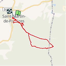
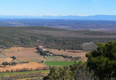
Ruta Senderismo de 7,4 km a descubrir en Provenza-Alpes-Costa Azul, Var, Saint-Martin-de-Pallières. Esta ruta ha sido propuesta por aubr.
Descripción
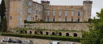
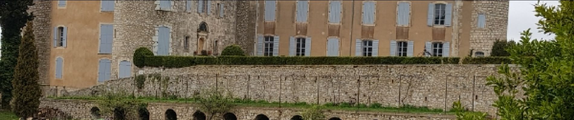
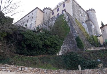
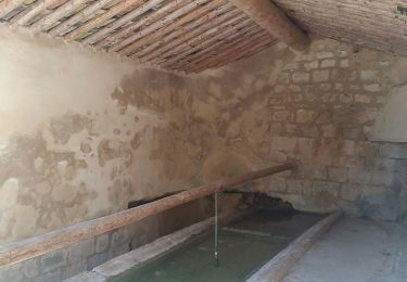
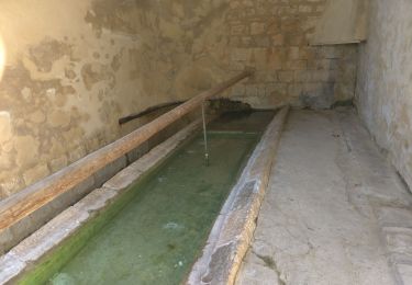
Boucle au départ de Saint Martin de Pallières
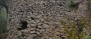
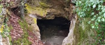
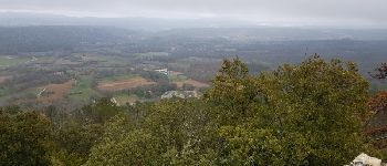
Vue sur le château, moulin ruiné , point de vue et grotte.
Ce circuit suit le fléchage bleu et partiellement le GR
Localización
País:
France
Región :
Provenza-Alpes-Costa Azul
Departamento/provincia :
Var
Municipio :
Saint-Martin-de-Pallières
Localidad:
Unknown
Salida:(Dec)
Salida:(UTM)
732908 ; 4830228 (31T) N.
Comentarios
Excursiones cerca
![Excursión Senderismo Esparron - les Crêtes d'Artigues 21.12.2024 - Photo](https://media.geolcdn.com/t/375/260/0dbe2802-f98a-46b7-873b-ed4e20a02570.jpg&format=jpg&maxdim=2)
![Senderismo Senderismo](https://static1.geolcdn.com/sitytour/trail-icons/101.png)
les Crêtes d'Artigues 21.12.2024
Senderismo
Medio
Esparron,
Provenza-Alpes-Costa Azul,
Var,
France
![](/images/other/stat-length.png)
12,1 km | 17,8 km-effort
4h 0min
![](https://static1.geolcdn.com/siteimages/upload/files/16400158638029165_repeat_loop_refresh_sync_direction_icon.png)
Sí
![Excursión Senderismo Esparron - 2Esparron de Pallières à Saint Martin de Pallières, c'est le retour.. - Photo](https://media.geolcdn.com/t/375/260/b2254a91-b889-4165-b542-844166d8477d.jpg&format=jpg&maxdim=2)
![Senderismo Senderismo](https://static1.geolcdn.com/sitytour/trail-icons/101.png)
2Esparron de Pallières à Saint Martin de Pallières, c'est le retour..
Senderismo
Fácil
Esparron,
Provenza-Alpes-Costa Azul,
Var,
France
![](/images/other/stat-length.png)
4,8 km | 6 km-effort
1h 11min
![](https://static1.geolcdn.com/siteimages/upload/files/16400158638029165_repeat_loop_refresh_sync_direction_icon.png)
No
![Excursión Senderismo Saint-Martin-de-Pallières - La montagne d'Artigues 16-12-2020 - Photo](https://media.geolcdn.com/t/375/260/82c33139-e6d3-44c8-94c6-9c65127cee96.jpg&format=jpg&maxdim=2)
![Senderismo Senderismo](https://static1.geolcdn.com/sitytour/trail-icons/101.png)
La montagne d'Artigues 16-12-2020
Senderismo
Medio
Saint-Martin-de-Pallières,
Provenza-Alpes-Costa Azul,
Var,
France
![](/images/other/stat-length.png)
20 km | 28 km-effort
6h 2min
![](https://static1.geolcdn.com/siteimages/upload/files/16400158638029165_repeat_loop_refresh_sync_direction_icon.png)
Sí
![Excursión Senderismo Esparron - Saint Martin de Pallieres- Esparron de Pallieres - Photo](https://media.geolcdn.com/t/375/260/8685a498-1592-4459-a358-4717225e52fa.jpg&format=jpg&maxdim=2)
![Senderismo Senderismo](https://static1.geolcdn.com/sitytour/trail-icons/101.png)
Saint Martin de Pallieres- Esparron de Pallieres
Senderismo
Medio
(1)
Esparron,
Provenza-Alpes-Costa Azul,
Var,
France
![](/images/other/stat-length.png)
14,5 km | 19,2 km-effort
5h 33min
![](https://static1.geolcdn.com/siteimages/upload/files/16400158638029165_repeat_loop_refresh_sync_direction_icon.png)
Sí
![Excursión Senderismo Esparron - Esparron les Pallières Saint Martin 12 juin 2019 - Photo](https://media.geolcdn.com/t/375/260/fef9c74a-441d-45e4-81ad-dc170e2d092e.jpg&format=jpg&maxdim=2)
![Senderismo Senderismo](https://static1.geolcdn.com/sitytour/trail-icons/101.png)
Esparron les Pallières Saint Martin 12 juin 2019
Senderismo
Medio
Esparron,
Provenza-Alpes-Costa Azul,
Var,
France
![](/images/other/stat-length.png)
14,7 km | 19,5 km-effort
5h 41min
![](https://static1.geolcdn.com/siteimages/upload/files/16400158638029165_repeat_loop_refresh_sync_direction_icon.png)
Sí
![Excursión Senderismo Esparron - 2025-01-17 Les Crêtes d'Artigues - Photo](https://media.geolcdn.com/t/375/260/ext.jpg?maxdim=2&url=https%3A%2F%2Fstatic1.geolcdn.com%2Fsiteimages%2Fupload%2Ffiles%2F1553511878bg_sport_marche.png)
![Senderismo Senderismo](https://static1.geolcdn.com/sitytour/trail-icons/101.png)
2025-01-17 Les Crêtes d'Artigues
Senderismo
Medio
Esparron,
Provenza-Alpes-Costa Azul,
Var,
France
![](/images/other/stat-length.png)
14,4 km | 21 km-effort
4h 44min
![](https://static1.geolcdn.com/siteimages/upload/files/16400158638029165_repeat_loop_refresh_sync_direction_icon.png)
Sí
![Excursión Senderismo Esparron - Montagne d’Artigues , traversée intégrale par la crête - Photo](https://media.geolcdn.com/t/375/260/33f72e15-e42d-4a11-a384-6e79b92ed1ce.jpg&format=jpg&maxdim=2)
![Senderismo Senderismo](https://static1.geolcdn.com/sitytour/trail-icons/101.png)
Montagne d’Artigues , traversée intégrale par la crête
Senderismo
Difícil
Esparron,
Provenza-Alpes-Costa Azul,
Var,
France
![](/images/other/stat-length.png)
13,9 km | 20 km-effort
4h 39min
![](https://static1.geolcdn.com/siteimages/upload/files/16400158638029165_repeat_loop_refresh_sync_direction_icon.png)
Sí
![Excursión Senderismo Saint-Martin-de-Pallières - Rando bistrot St Martin de Pailleres - Photo](https://media.geolcdn.com/t/375/260/ext.jpg?maxdim=2&url=https%3A%2F%2Fstatic1.geolcdn.com%2Fsiteimages%2Fupload%2Ffiles%2F1553511878bg_sport_marche.png)
![Senderismo Senderismo](https://static1.geolcdn.com/sitytour/trail-icons/101.png)
Rando bistrot St Martin de Pailleres
Senderismo
Difícil
Saint-Martin-de-Pallières,
Provenza-Alpes-Costa Azul,
Var,
France
![](/images/other/stat-length.png)
9,7 km | 13 km-effort
2h 32min
![](https://static1.geolcdn.com/siteimages/upload/files/16400158638029165_repeat_loop_refresh_sync_direction_icon.png)
Sí
![Excursión Senderismo Saint-Martin-de-Pallières - Valensole boucle sur le plateau - Photo](https://media.geolcdn.com/t/375/260/ext.jpg?maxdim=2&url=https%3A%2F%2Fstatic1.geolcdn.com%2Fsiteimages%2Fupload%2Ffiles%2F1553511878bg_sport_marche.png)
![Senderismo Senderismo](https://static1.geolcdn.com/sitytour/trail-icons/101.png)
Valensole boucle sur le plateau
Senderismo
Saint-Martin-de-Pallières,
Provenza-Alpes-Costa Azul,
Var,
France
![](/images/other/stat-length.png)
104 km | 123 km-effort
16h 3min
![](https://static1.geolcdn.com/siteimages/upload/files/16400158638029165_repeat_loop_refresh_sync_direction_icon.png)
No