![](/images/other/stat-length.png)
![Excursión Senderismo Manneville-ès-Plains - Mannevilles-Es -Plains - Photo](https://media.geolcdn.com/t/1900/400/ext.pjpeg?maxdim=2&url=https%3A%2F%2Fstatic1.geolcdn.com%2Fsiteimages%2Fupload%2Ffiles%2F1553511878bg_sport_marche.png)
Mannevilles-Es -Plains
randojj
Usuario
![Longitud](/images/other/stat-length.png)
Longitud
9,8 km
![Altitud máxima](https://static1.geolcdn.com/siteimages/upload/files/1508320355ic_sort_altitude_max_24dp.png)
Altitud máxima
84 m
![Desnivel positivo](https://static1.geolcdn.com/siteimages/upload/files/1508320355ic_sort_den_pos_24dp.png)
Desnivel positivo
106 m
![Km-Effort](/images/other/stat-length.png)
Km-Effort
11,3 km
![Altitud mínima](https://static1.geolcdn.com/siteimages/upload/files/1508320355ic_sort_altitude_min_24dp.png)
Altitud mínima
6 m
![Desnivel negativo](https://static1.geolcdn.com/siteimages/upload/files/1508320355ic_sort_den_neg_24dp.png)
Desnivel negativo
105 m
![Boucle](https://static1.geolcdn.com/siteimages/upload/files/16400158638029165_repeat_loop_refresh_sync_direction_icon.png)
Boucle
Sí
Fecha de creación :
2019-04-26 07:45:26.4
Última modificación :
2019-04-26 07:45:26.426
![Senderismo](https://static1.geolcdn.com/sitytour/trail-icons/101.png)
2h27
Dificultad : Medio
![Escanee este código QR para abrir la excursión en la aplicación SityTrail](https://capi.geolives.com/qq0zvz2zws4bq2lad0pu/sitytour/trails/918712/qr.png?size=200)
Aplicación GPS de excursión GRATIS
A propósito
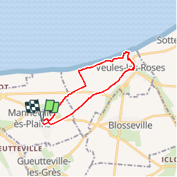
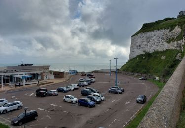
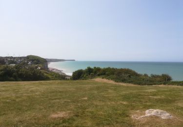
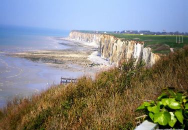
Ruta Senderismo de 9,8 km a descubrir en Normandía, Sena-Marítimo, Manneville-ès-Plains. Esta ruta ha sido propuesta por randojj.
Descripción
Départ église de Manneville Es Plains.Petit tour dans Veules les Roses en suivant le plus petit fleuve de France " La Veules".
Localización
País:
France
Región :
Normandía
Departamento/provincia :
Sena-Marítimo
Municipio :
Manneville-ès-Plains
Localidad:
Unknown
Salida:(Dec)
Salida:(UTM)
338658 ; 5524870 (31U) N.
Comentarios
Excursiones cerca
![Excursión Senderismo Veules-les-Roses - Circuit du plus petit Fleuve de France - Veules Les Roses - Photo](https://media.geolcdn.com/t/375/260/ext.jpg?maxdim=2&url=https%3A%2F%2Fservices.sitytrail.com%2FGeolivesWS%2FDownloadMedia.ashx%3FTrailID%3D172676%26Media%3D14059_2.jpg)
![Senderismo Senderismo](https://static1.geolcdn.com/sitytour/trail-icons/101.png)
Circuit du plus petit Fleuve de France - Veules Les Roses
Senderismo
Fácil
(4)
Veules-les-Roses,
Normandía,
Sena-Marítimo,
France
![](/images/other/stat-length.png)
4 km | 5,3 km-effort
1h 30min
![](https://static1.geolcdn.com/siteimages/upload/files/16400158638029165_repeat_loop_refresh_sync_direction_icon.png)
Sí
![Excursión Senderismo Veules-les-Roses - Circuit du plus petit Fleuve de France – Veules Les Roses - Photo](https://media.geolcdn.com/t/375/260/ext.jpg?maxdim=2&url=https%3A%2F%2Fservices.sitytrail.com%2FGeolivesWS%2FDownloadMedia.ashx%3FTrailID%3D155303%26Media%3D4c344425-a5c2-4255-8220-3432dbd8805b.JPG)
![Senderismo Senderismo](https://static1.geolcdn.com/sitytour/trail-icons/101.png)
Circuit du plus petit Fleuve de France – Veules Les Roses
Senderismo
Muy fácil
(2)
Veules-les-Roses,
Normandía,
Sena-Marítimo,
France
![](/images/other/stat-length.png)
4 km | 5,3 km-effort
1h 30min
![](https://static1.geolcdn.com/siteimages/upload/files/16400158638029165_repeat_loop_refresh_sync_direction_icon.png)
Sí
![Excursión Bici de carretera Saint-Valery-en-Caux - Sainte Marie La Flotte retour - Photo](https://media.geolcdn.com/t/375/260/c953ac11-fd11-47b9-9f84-6149c27e4f08.jpg&format=jpg&maxdim=2)
![Bici de carretera Bici de carretera](https://static1.geolcdn.com/sitytour/trail-icons/201.png)
Sainte Marie La Flotte retour
Bici de carretera
Fácil
Saint-Valery-en-Caux,
Normandía,
Sena-Marítimo,
France
![](/images/other/stat-length.png)
554 km | 638 km-effort
2h 38min
![](https://static1.geolcdn.com/siteimages/upload/files/16400158638029165_repeat_loop_refresh_sync_direction_icon.png)
No
![Excursión Senderismo Saint-Valery-en-Caux - boucle de st valery en cause à veules et retour par la plage - Photo](https://media.geolcdn.com/t/375/260/1b47ad71-45e2-413b-af01-56a4ea59949a.jpg&format=jpg&maxdim=2)
![Senderismo Senderismo](https://static1.geolcdn.com/sitytour/trail-icons/101.png)
boucle de st valery en cause à veules et retour par la plage
Senderismo
Muy difícil
Saint-Valery-en-Caux,
Normandía,
Sena-Marítimo,
France
![](/images/other/stat-length.png)
18,4 km | 21 km-effort
4h 40min
![](https://static1.geolcdn.com/siteimages/upload/files/16400158638029165_repeat_loop_refresh_sync_direction_icon.png)
No
![Excursión Senderismo Ermenouville - Ermenouvillle - Le Mesnil Geoffroy - Photo](https://media.geolcdn.com/t/375/260/5bb1fe76-5828-4c00-8543-c120e4c71a2a.jpg&format=jpg&maxdim=2)
![Senderismo Senderismo](https://static1.geolcdn.com/sitytour/trail-icons/101.png)
Ermenouvillle - Le Mesnil Geoffroy
Senderismo
Muy fácil
Ermenouville,
Normandía,
Sena-Marítimo,
France
![](/images/other/stat-length.png)
15,3 km | 17,2 km-effort
5h 26min
![](https://static1.geolcdn.com/siteimages/upload/files/16400158638029165_repeat_loop_refresh_sync_direction_icon.png)
Sí
![Excursión Senderismo Veules-les-Roses - Balade à Veules les Roses - Photo](https://media.geolcdn.com/t/375/260/1920cf90-1057-4f37-90a3-d3e91d6cd23d.jpg&format=jpg&maxdim=2)
![Senderismo Senderismo](https://static1.geolcdn.com/sitytour/trail-icons/101.png)
Balade à Veules les Roses
Senderismo
Muy fácil
Veules-les-Roses,
Normandía,
Sena-Marítimo,
France
![](/images/other/stat-length.png)
3,8 km | 4,9 km-effort
1h 56min
![](https://static1.geolcdn.com/siteimages/upload/files/16400158638029165_repeat_loop_refresh_sync_direction_icon.png)
Sí
![Excursión Otra actividad Le Mesnil-Durdent - Les Amouhoques - Le Mesmil-Durdent - Photo](https://media.geolcdn.com/t/375/260/ext.jpg?maxdim=2&url=https%3A%2F%2Fservices.sitytrail.com%2FGeolivesWS%2FDownloadMedia.ashx%3FTrailID%3D317494%26Media%3D16728_5.jpg)
![Otra actividad Otra actividad](https://static1.geolcdn.com/sitytour/trail-icons/900.png)
Les Amouhoques - Le Mesmil-Durdent
Otra actividad
Difícil
Le Mesnil-Durdent,
Normandía,
Sena-Marítimo,
France
![](/images/other/stat-length.png)
18,9 km | 22 km-effort
2h 0min
![](https://static1.geolcdn.com/siteimages/upload/files/16400158638029165_repeat_loop_refresh_sync_direction_icon.png)
Sí
![Excursión Senderismo Le Mesnil-Durdent - Les Amouhoques - Le Mesmil-Durdent - Photo](https://media.geolcdn.com/t/375/260/ext.jpg?maxdim=2&url=https%3A%2F%2Fservices.sitytrail.com%2FGeolivesWS%2FDownloadMedia.ashx%3FTrailID%3D317493%26Media%3D16728_5.jpg)
![Senderismo Senderismo](https://static1.geolcdn.com/sitytour/trail-icons/101.png)
Les Amouhoques - Le Mesmil-Durdent
Senderismo
Difícil
Le Mesnil-Durdent,
Normandía,
Sena-Marítimo,
France
![](/images/other/stat-length.png)
18,9 km | 22 km-effort
5h 0min
![](https://static1.geolcdn.com/siteimages/upload/files/16400158638029165_repeat_loop_refresh_sync_direction_icon.png)
Sí
![Excursión Otra actividad Sotteville-sur-Mer - Aux Sources de la Veules - Photo](https://media.geolcdn.com/t/375/260/ext.jpg?maxdim=2&url=https%3A%2F%2Fservices.sitytrail.com%2FGeolivesWS%2FDownloadMedia.ashx%3FTrailID%3D317480%26Media%3D16712_6.jpg)
![Otra actividad Otra actividad](https://static1.geolcdn.com/sitytour/trail-icons/900.png)
Aux Sources de la Veules
Otra actividad
Medio
Sotteville-sur-Mer,
Normandía,
Sena-Marítimo,
France
![](/images/other/stat-length.png)
8,1 km | 9,6 km-effort
1h 0min
![](https://static1.geolcdn.com/siteimages/upload/files/16400158638029165_repeat_loop_refresh_sync_direction_icon.png)
Sí