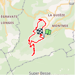
![](/images/other/stat-length.png)
![Excursión Raquetas de nieve Chambon-sur-Lac - Chaudefour - Puy de Champgourdeix Chambon des Neiges - Photo](https://media.geolcdn.com/t/1900/400/ext.pjpeg?maxdim=2&url=https%3A%2F%2Fstatic1.geolcdn.com%2Fsiteimages%2Fupload%2Ffiles%2F1524743153raquette.jpg)
Chaudefour - Puy de Champgourdeix Chambon des Neiges
olibreizh
Usuario
![Longitud](/images/other/stat-length.png)
![Altitud máxima](https://static1.geolcdn.com/siteimages/upload/files/1508320355ic_sort_altitude_max_24dp.png)
![Desnivel positivo](https://static1.geolcdn.com/siteimages/upload/files/1508320355ic_sort_den_pos_24dp.png)
![Km-Effort](/images/other/stat-length.png)
![Altitud mínima](https://static1.geolcdn.com/siteimages/upload/files/1508320355ic_sort_altitude_min_24dp.png)
![Desnivel negativo](https://static1.geolcdn.com/siteimages/upload/files/1508320355ic_sort_den_neg_24dp.png)
![Boucle](https://static1.geolcdn.com/siteimages/upload/files/16400158638029165_repeat_loop_refresh_sync_direction_icon.png)
![Raquetas de nieve](https://static1.geolcdn.com/sitytour/trail-icons/504.png)
4h51
Dificultad : Difícil
![Escanee este código QR para abrir la excursión en la aplicación SityTrail](https://capi.geolives.com/qq0zvz2zws4bq2lad0pu/sitytour/trails/918237/qr.png?size=200)
Aplicación GPS de excursión GRATIS
A propósito
Ruta Raquetas de nieve de 15 km a descubrir en Auvergne-Rhône-Alpes, Puy-de-Dôme, Chambon-sur-Lac. Esta ruta ha sido propuesta por olibreizh.
Descripción
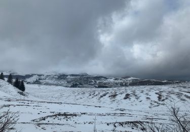
Tour en raquettes et à pieds au départ de la Maison de la réserve Naturelle du Chaudefour. Départ en fond de Vallée puis ascension du Puy de Champgourdeix par la Rondaire. Retour par la même voie et direction Chambon des neiges par les rochers de l'Audiouze (passage difficile en raquettes). Retour en contournant le Puy Jumel
Localización
Comentarios
Excursiones cerca
![Excursión Senderismo Mont-Dore - Montée au sommet du Puy de Sancy - Photo](https://media.geolcdn.com/t/375/260/1486ae36-afa6-41d3-a8cf-03841ddf3ad3.jpg&format=jpg&maxdim=2)
![Senderismo Senderismo](https://static1.geolcdn.com/sitytour/trail-icons/101.png)
Senderismo
![](/images/other/stat-length.png)
![](https://static1.geolcdn.com/siteimages/upload/files/16400158638029165_repeat_loop_refresh_sync_direction_icon.png)
![Excursión Senderismo Chambon-sur-Lac - Chambon_Couze_Surains - Photo](https://media.geolcdn.com/t/375/260/69ddf9d1-6553-4ac4-9be3-6827620eb27f.jpg&format=jpg&maxdim=2)
![Senderismo Senderismo](https://static1.geolcdn.com/sitytour/trail-icons/101.png)
Senderismo
![](/images/other/stat-length.png)
![](https://static1.geolcdn.com/siteimages/upload/files/16400158638029165_repeat_loop_refresh_sync_direction_icon.png)
![Senderismo Senderismo](https://static1.geolcdn.com/sitytour/trail-icons/101.png)
Senderismo
![](/images/other/stat-length.png)
![](https://static1.geolcdn.com/siteimages/upload/files/16400158638029165_repeat_loop_refresh_sync_direction_icon.png)
![Excursión Senderismo Besse-et-Saint-Anastaise - Sancy par Super-Besse - Photo](https://media.geolcdn.com/t/375/260/ext.jpg?maxdim=2&url=https%3A%2F%2Fservices.sitytrail.com%2FGeolivesWS%2FDownloadMedia.ashx%3FTrailID%3D317232%26Media%3D16410_6.jpg)
![Senderismo Senderismo](https://static1.geolcdn.com/sitytour/trail-icons/101.png)
Senderismo
![](/images/other/stat-length.png)
![](https://static1.geolcdn.com/siteimages/upload/files/16400158638029165_repeat_loop_refresh_sync_direction_icon.png)
![Excursión Senderismo Besse-et-Saint-Anastaise - Lac_Pavin_Montchal - Photo](https://media.geolcdn.com/t/375/260/0a17a073-6f46-4dad-9995-801fb5c96c4d.jpg&format=jpg&maxdim=2)
![Senderismo Senderismo](https://static1.geolcdn.com/sitytour/trail-icons/101.png)
Senderismo
![](/images/other/stat-length.png)
![](https://static1.geolcdn.com/siteimages/upload/files/16400158638029165_repeat_loop_refresh_sync_direction_icon.png)
![Excursión Senderismo Besse-et-Saint-Anastaise - Les 3 lacs et la cascade - Photo](https://media.geolcdn.com/t/375/260/50f54827-36a7-4b68-99c1-d5774caacba8.jpg&format=jpg&maxdim=2)
![Senderismo Senderismo](https://static1.geolcdn.com/sitytour/trail-icons/101.png)
Senderismo
![](/images/other/stat-length.png)
![](https://static1.geolcdn.com/siteimages/upload/files/16400158638029165_repeat_loop_refresh_sync_direction_icon.png)
![Senderismo Senderismo](https://static1.geolcdn.com/sitytour/trail-icons/101.png)
Senderismo
![](/images/other/stat-length.png)
![](https://static1.geolcdn.com/siteimages/upload/files/16400158638029165_repeat_loop_refresh_sync_direction_icon.png)
![Excursión Senderismo Chambon-sur-Lac - Chambon_Moneaux - Photo](https://media.geolcdn.com/t/375/260/460725f3-6d73-441e-a5c8-44b8d6b3875e.jpg&format=jpg&maxdim=2)
![Senderismo Senderismo](https://static1.geolcdn.com/sitytour/trail-icons/101.png)
Senderismo
![](/images/other/stat-length.png)
![](https://static1.geolcdn.com/siteimages/upload/files/16400158638029165_repeat_loop_refresh_sync_direction_icon.png)
![Senderismo Senderismo](https://static1.geolcdn.com/sitytour/trail-icons/101.png)
Senderismo
![](/images/other/stat-length.png)
![](https://static1.geolcdn.com/siteimages/upload/files/16400158638029165_repeat_loop_refresh_sync_direction_icon.png)