![](/images/other/stat-length.png)
![Excursión Bicicleta Puente-San-Maxence - balade foret halatte - Photo](https://media.geolcdn.com/t/1900/400/ext.pjpeg?maxdim=2&url=https%3A%2F%2Fservices.sitytrail.com%2FGeolivesWS%2FDownloadMedia.ashx%3FTrailID%3D918230%26Media%3D1608443e-a357-4f0e-a3f7-8f8d76198c7f.jpg)
balade foret halatte
gilbertdu60
Usuario
![Longitud](/images/other/stat-length.png)
![Altitud máxima](https://static1.geolcdn.com/siteimages/upload/files/1508320355ic_sort_altitude_max_24dp.png)
![Desnivel positivo](https://static1.geolcdn.com/siteimages/upload/files/1508320355ic_sort_den_pos_24dp.png)
![Km-Effort](/images/other/stat-length.png)
![Altitud mínima](https://static1.geolcdn.com/siteimages/upload/files/1508320355ic_sort_altitude_min_24dp.png)
![Desnivel negativo](https://static1.geolcdn.com/siteimages/upload/files/1508320355ic_sort_den_neg_24dp.png)
![Boucle](https://static1.geolcdn.com/siteimages/upload/files/16400158638029165_repeat_loop_refresh_sync_direction_icon.png)
![Bicicleta](https://static1.geolcdn.com/sitytour/trail-icons/200.png)
1h55
Dificultad : Fácil
![Escanee este código QR para abrir la excursión en la aplicación SityTrail](https://capi.geolives.com/qq0zvz2zws4bq2lad0pu/sitytour/trails/918230/qr.png?size=200)
Aplicación GPS de excursión GRATIS
A propósito
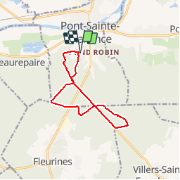
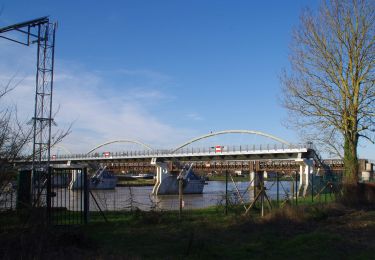
Ruta Bicicleta de 10,4 km a descubrir en Alta Francia, Oise, Puente-San-Maxence. Esta ruta ha sido propuesta por gilbertdu60.
Descripción
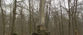
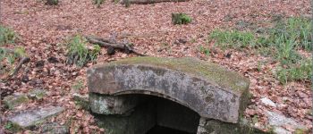
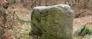
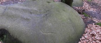
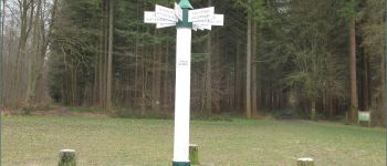
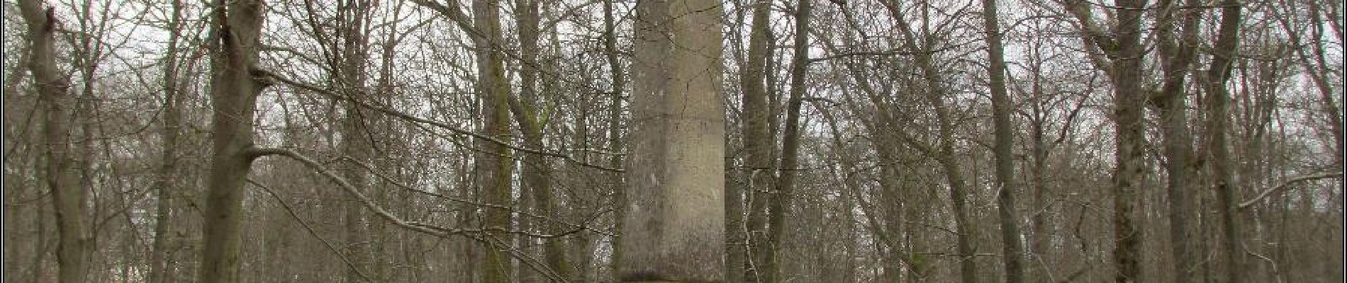
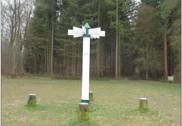
départ piscine des terriers, ( traversée de la RD1017) vers l'obélisque du roi de Rome et la fontaine des Lys, passage par le poteau du grand maitre, vers le chemin du cheval blanc arrêt au dolme de Chancy, vers le rocher au sanglier
Localización
Comentarios
Excursiones cerca
![Excursión Senderismo Beaurepaire - La mare aux oiseaux - Beaurepaire - Photo](https://media.geolcdn.com/t/375/260/ext.jpg?maxdim=2&url=https%3A%2F%2Fservices.sitytrail.com%2FGeolivesWS%2FDownloadMedia.ashx%3FTrailID%3D172831%26Media%3D14265_3.jpg)
![Senderismo Senderismo](https://static1.geolcdn.com/sitytour/trail-icons/101.png)
Senderismo
![](/images/other/stat-length.png)
![](https://static1.geolcdn.com/siteimages/upload/files/16400158638029165_repeat_loop_refresh_sync_direction_icon.png)
![Excursión Senderismo Fleurines - Fleurines Grand parcours - Photo](https://media.geolcdn.com/t/375/260/ext.jpg?maxdim=2&url=https%3A%2F%2Fstatic1.geolcdn.com%2Fsiteimages%2Fupload%2Ffiles%2F1553511878bg_sport_marche.png)
![Senderismo Senderismo](https://static1.geolcdn.com/sitytour/trail-icons/101.png)
Senderismo
![](/images/other/stat-length.png)
![](https://static1.geolcdn.com/siteimages/upload/files/16400158638029165_repeat_loop_refresh_sync_direction_icon.png)
![Excursión Senderismo Pontpoint - Mont Pagnotte Grand parcours - Photo](https://media.geolcdn.com/t/375/260/ext.jpg?maxdim=2&url=https%3A%2F%2Fstatic1.geolcdn.com%2Fsiteimages%2Fupload%2Ffiles%2F1553511878bg_sport_marche.png)
![Senderismo Senderismo](https://static1.geolcdn.com/sitytour/trail-icons/101.png)
Senderismo
![](/images/other/stat-length.png)
![](https://static1.geolcdn.com/siteimages/upload/files/16400158638029165_repeat_loop_refresh_sync_direction_icon.png)
![Excursión Bici de montaña Puente-San-Maxence - ot 6 octobre 24 - Photo](https://media.geolcdn.com/t/375/260/4ba8675b-f1b4-4711-8652-1227646fd10f.jpg&format=jpg&maxdim=2)
![Bici de montaña Bici de montaña](https://static1.geolcdn.com/sitytour/trail-icons/202.png)
Bici de montaña
![](/images/other/stat-length.png)
![](https://static1.geolcdn.com/siteimages/upload/files/16400158638029165_repeat_loop_refresh_sync_direction_icon.png)
![Excursión Bicicleta híbrida Fleurines - randonnée Au5v OT Ccpoh halatte - Photo](https://media.geolcdn.com/t/375/260/e4619b64-6ffd-453c-8063-35f7d7e4513e.jpg&format=jpg&maxdim=2)
![Bicicleta híbrida Bicicleta híbrida](https://static1.geolcdn.com/sitytour/trail-icons/203.png)
Bicicleta híbrida
![](/images/other/stat-length.png)
![](https://static1.geolcdn.com/siteimages/upload/files/16400158638029165_repeat_loop_refresh_sync_direction_icon.png)
![Excursión Cicloturismo Puente-San-Maxence - sortie AU5v Pentecôte 2022 - Photo](https://media.geolcdn.com/t/375/260/72742583-c7e6-4761-a433-7f77fdf4fdf5.jpg&format=jpg&maxdim=2)
![Cicloturismo Cicloturismo](https://static1.geolcdn.com/sitytour/trail-icons/204.png)
Cicloturismo
![](/images/other/stat-length.png)
![](https://static1.geolcdn.com/siteimages/upload/files/16400158638029165_repeat_loop_refresh_sync_direction_icon.png)
![Excursión A pie Puente-San-Maxence - balade pedestre 11 avril 2022 - Photo](https://media.geolcdn.com/t/375/260/80b47c68-2cf3-4ca1-99f4-54eb29551880.jpg&format=jpg&maxdim=2)
![A pie A pie](https://static1.geolcdn.com/sitytour/trail-icons/100.png)
A pie
![](/images/other/stat-length.png)
![](https://static1.geolcdn.com/siteimages/upload/files/16400158638029165_repeat_loop_refresh_sync_direction_icon.png)
![Excursión Bici eléctrica Puente-San-Maxence - balade printanière du 23 mars - Photo](https://media.geolcdn.com/t/375/260/91c5558e-d792-4457-81d8-689705073d14.jpg&format=jpg&maxdim=2)
![Bici eléctrica Bici eléctrica](https://static1.geolcdn.com/sitytour/trail-icons/205.png)
Bici eléctrica
![](/images/other/stat-length.png)
![](https://static1.geolcdn.com/siteimages/upload/files/16400158638029165_repeat_loop_refresh_sync_direction_icon.png)
![Excursión Bici eléctrica Puente-San-Maxence - sortie 18 janvier 22 - Photo](https://media.geolcdn.com/t/375/260/a2770608-26de-4cec-b3ee-2ce8fe1ad8d3.jpg&format=jpg&maxdim=2)
![Bici eléctrica Bici eléctrica](https://static1.geolcdn.com/sitytour/trail-icons/205.png)
Bici eléctrica
![](/images/other/stat-length.png)
![](https://static1.geolcdn.com/siteimages/upload/files/16400158638029165_repeat_loop_refresh_sync_direction_icon.png)