![](/images/other/stat-length.png)
![Excursión Senderismo Bouère - De Bouère à St-Brice - Photo](https://media.geolcdn.com/t/1900/400/ext.pjpeg?maxdim=2&url=https%3A%2F%2Fstatic1.geolcdn.com%2Fsiteimages%2Fupload%2Ffiles%2F1553511878bg_sport_marche.png)
De Bouère à St-Brice
neoroll44
Usuario
![Longitud](/images/other/stat-length.png)
Longitud
13 km
![Altitud máxima](https://static1.geolcdn.com/siteimages/upload/files/1508320355ic_sort_altitude_max_24dp.png)
Altitud máxima
83 m
![Desnivel positivo](https://static1.geolcdn.com/siteimages/upload/files/1508320355ic_sort_den_pos_24dp.png)
Desnivel positivo
142 m
![Km-Effort](/images/other/stat-length.png)
Km-Effort
14,9 km
![Altitud mínima](https://static1.geolcdn.com/siteimages/upload/files/1508320355ic_sort_altitude_min_24dp.png)
Altitud mínima
46 m
![Desnivel negativo](https://static1.geolcdn.com/siteimages/upload/files/1508320355ic_sort_den_neg_24dp.png)
Desnivel negativo
143 m
![Boucle](https://static1.geolcdn.com/siteimages/upload/files/16400158638029165_repeat_loop_refresh_sync_direction_icon.png)
Boucle
Sí
Fecha de creación :
2018-04-17 16:59:16.576
Última modificación :
2018-04-17 16:59:16.576
![Senderismo](https://static1.geolcdn.com/sitytour/trail-icons/101.png)
3h15
Dificultad : Medio
![Escanee este código QR para abrir la excursión en la aplicación SityTrail](https://capi.geolives.com/qq0zvz2zws4bq2lad0pu/sitytour/trails/893860/qr.png?size=200)
Aplicación GPS de excursión GRATIS
A propósito
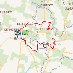
Ruta Senderismo de 13 km a descubrir en Países del Loira, Mayenne, Bouère. Esta ruta ha sido propuesta por neoroll44.
Descripción
Non loin de la forêt de Bellebranche.
De l'église, prendre le CD 14 vers Grez en Bouère, puis à droite vers la croix verte.
Puis le Moulin Neuf, Manchetière, près de Bellebranche et retour par St-Brice et le plan d'eau.
Localización
País:
France
Región :
Países del Loira
Departamento/provincia :
Mayenne
Municipio :
Bouère
Localidad:
Unknown
Salida:(Dec)
Salida:(UTM)
688652 ; 5304229 (30T) N.
Comentarios
Excursiones cerca
![Excursión Senderismo Bouère - Bouère. Circuit N4 - Photo](https://media.geolcdn.com/t/375/260/ext.jpg?maxdim=2&url=https%3A%2F%2Fstatic1.geolcdn.com%2Fsiteimages%2Fupload%2Ffiles%2F1553511878bg_sport_marche.png)
![Senderismo Senderismo](https://static1.geolcdn.com/sitytour/trail-icons/101.png)
Bouère. Circuit N4
Senderismo
Fácil
(1)
Bouère,
Países del Loira,
Mayenne,
France
![](/images/other/stat-length.png)
4,5 km | 5,4 km-effort
1h 38min
![](https://static1.geolcdn.com/siteimages/upload/files/16400158638029165_repeat_loop_refresh_sync_direction_icon.png)
Sí
![Excursión Senderismo Grez-en-Bouère - Grez en Bouère - Photo](https://media.geolcdn.com/t/375/260/ext.jpg?maxdim=2&url=https%3A%2F%2Fstatic1.geolcdn.com%2Fsiteimages%2Fupload%2Ffiles%2F1553511878bg_sport_marche.png)
![Senderismo Senderismo](https://static1.geolcdn.com/sitytour/trail-icons/101.png)
Grez en Bouère
Senderismo
Medio
Grez-en-Bouère,
Países del Loira,
Mayenne,
France
![](/images/other/stat-length.png)
12,8 km | 14,8 km-effort
3h 20min
![](https://static1.geolcdn.com/siteimages/upload/files/16400158638029165_repeat_loop_refresh_sync_direction_icon.png)
Sí
![Excursión Senderismo Saint-Brice - 2024 06 02 bellebranche - Photo](https://media.geolcdn.com/t/375/260/ext.jpg?maxdim=2&url=https%3A%2F%2Fstatic1.geolcdn.com%2Fsiteimages%2Fupload%2Ffiles%2F1553511878bg_sport_marche.png)
![Senderismo Senderismo](https://static1.geolcdn.com/sitytour/trail-icons/101.png)
2024 06 02 bellebranche
Senderismo
Fácil
Saint-Brice,
Países del Loira,
Mayenne,
France
![](/images/other/stat-length.png)
9 km | 10,4 km-effort
1h 59min
![](https://static1.geolcdn.com/siteimages/upload/files/16400158638029165_repeat_loop_refresh_sync_direction_icon.png)
Sí
![Excursión Geocaching Saint-Loup-du-Dorat - Labyrinthe Alice Juillet 2022 - Photo](https://media.geolcdn.com/t/375/260/ext.jpg?maxdim=2&url=https%3A%2F%2Fstatic1.geolcdn.com%2Fsiteimages%2Fupload%2Ffiles%2F1545311037marcheuse_200dpi.jpg)
![Geocaching Geocaching](https://static1.geolcdn.com/sitytour/trail-icons/908.png)
Labyrinthe Alice Juillet 2022
Geocaching
Medio
Saint-Loup-du-Dorat,
Países del Loira,
Mayenne,
France
![](/images/other/stat-length.png)
11,8 km | 13,1 km-effort
2h 50min
![](https://static1.geolcdn.com/siteimages/upload/files/16400158638029165_repeat_loop_refresh_sync_direction_icon.png)
No
![Excursión Senderismo Bouère - de Bouère à Grez - Photo](https://media.geolcdn.com/t/375/260/ext.jpg?maxdim=2&url=https%3A%2F%2Fstatic1.geolcdn.com%2Fsiteimages%2Fupload%2Ffiles%2F1553511878bg_sport_marche.png)
![Senderismo Senderismo](https://static1.geolcdn.com/sitytour/trail-icons/101.png)
de Bouère à Grez
Senderismo
Muy fácil
Bouère,
Países del Loira,
Mayenne,
France
![](/images/other/stat-length.png)
14,4 km | 16,6 km-effort
3h 55min
![](https://static1.geolcdn.com/siteimages/upload/files/16400158638029165_repeat_loop_refresh_sync_direction_icon.png)
Sí
![Excursión Senderismo Bouère - Bouère. autour du village - Photo](https://media.geolcdn.com/t/375/260/ext.jpg?maxdim=2&url=https%3A%2F%2Fstatic1.geolcdn.com%2Fsiteimages%2Fupload%2Ffiles%2F1553511878bg_sport_marche.png)
![Senderismo Senderismo](https://static1.geolcdn.com/sitytour/trail-icons/101.png)
Bouère. autour du village
Senderismo
Medio
Bouère,
Países del Loira,
Mayenne,
France
![](/images/other/stat-length.png)
11,4 km | 13,1 km-effort
3h 5min
![](https://static1.geolcdn.com/siteimages/upload/files/16400158638029165_repeat_loop_refresh_sync_direction_icon.png)
Sí
![Excursión Senderismo Saint-Brice - Saint-Brice Marche à pied - Photo](https://media.geolcdn.com/t/375/260/ext.jpg?maxdim=2&url=https%3A%2F%2Fstatic1.geolcdn.com%2Fsiteimages%2Fupload%2Ffiles%2F1553511878bg_sport_marche.png)
![Senderismo Senderismo](https://static1.geolcdn.com/sitytour/trail-icons/101.png)
Saint-Brice Marche à pied
Senderismo
Medio
Saint-Brice,
Países del Loira,
Mayenne,
France
![](/images/other/stat-length.png)
9,2 km | 10,6 km-effort
2h 19min
![](https://static1.geolcdn.com/siteimages/upload/files/16400158638029165_repeat_loop_refresh_sync_direction_icon.png)
Sí