![](/images/other/stat-length.png)
![Excursión Senderismo Château-Chalon - EC5b_château chalon- belvédère Crançot - Photo](https://media.geolcdn.com/t/1900/400/ext.pjpeg?maxdim=2&url=https%3A%2F%2Fstatic1.geolcdn.com%2Fsiteimages%2Fupload%2Ffiles%2F1553511878bg_sport_marche.png)
EC5b_château chalon- belvédère Crançot
bernard54
Usuario
![Longitud](/images/other/stat-length.png)
Longitud
15 km
![Altitud máxima](https://static1.geolcdn.com/siteimages/upload/files/1508320355ic_sort_altitude_max_24dp.png)
Altitud máxima
536 m
![Desnivel positivo](https://static1.geolcdn.com/siteimages/upload/files/1508320355ic_sort_den_pos_24dp.png)
Desnivel positivo
578 m
![Km-Effort](/images/other/stat-length.png)
Km-Effort
23 km
![Altitud mínima](https://static1.geolcdn.com/siteimages/upload/files/1508320355ic_sort_altitude_min_24dp.png)
Altitud mínima
304 m
![Desnivel negativo](https://static1.geolcdn.com/siteimages/upload/files/1508320355ic_sort_den_neg_24dp.png)
Desnivel negativo
528 m
![Boucle](https://static1.geolcdn.com/siteimages/upload/files/16400158638029165_repeat_loop_refresh_sync_direction_icon.png)
Boucle
No
Fecha de creación :
2018-04-17 16:56:29.844
Última modificación :
2018-04-17 16:56:29.844
![Senderismo](https://static1.geolcdn.com/sitytour/trail-icons/101.png)
4h47
Dificultad : Muy difícil
![Escanee este código QR para abrir la excursión en la aplicación SityTrail](https://capi.geolives.com/qq0zvz2zws4bq2lad0pu/sitytour/trails/893429/qr.png?size=200)
Aplicación GPS de excursión GRATIS
A propósito
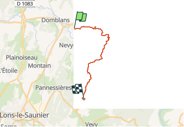
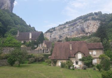
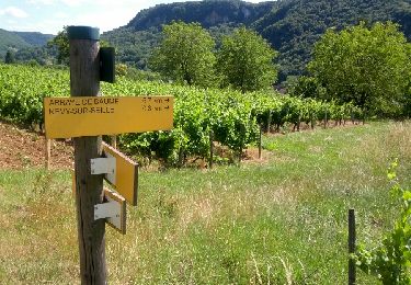
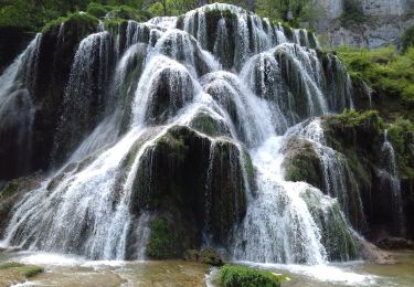
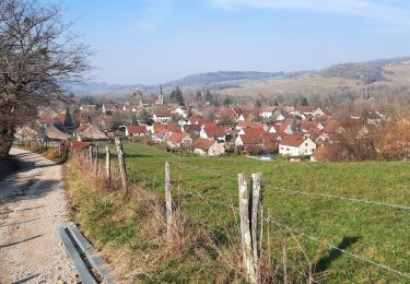
Ruta Senderismo de 15 km a descubrir en Borgoña-Franco Condado, Jura, Château-Chalon. Esta ruta ha sido propuesta por bernard54.
Descripción
Échappée Jurassienne Etape 5 Château Chalon - Belvédère de Crançot puis transfert voiture vers Le Frasnois - Gite étape l'éolienne hameau la fromagerie 39130 le Frasnois 03 84 25 50 60 - 06 82 95 27 33
Localización
País:
France
Región :
Borgoña-Franco Condado
Departamento/provincia :
Jura
Municipio :
Château-Chalon
Localidad:
Unknown
Salida:(Dec)
Salida:(UTM)
700552 ; 5181242 (31T) N.
Comentarios
Excursiones cerca
![Excursión Senderismo Baume-les-Messieurs - Baume-les-Messieurs - Photo](https://media.geolcdn.com/t/375/260/ext.jpg?maxdim=2&url=https%3A%2F%2Fservices.sitytrail.com%2FGeolivesWS%2FDownloadMedia.ashx%3FTrailID%3D792634%26Media%3Dfix__20170719130529.jpg)
![Senderismo Senderismo](https://static1.geolcdn.com/sitytour/trail-icons/101.png)
Baume-les-Messieurs
Senderismo
Medio
(1)
Baume-les-Messieurs,
Borgoña-Franco Condado,
Jura,
France
![](/images/other/stat-length.png)
10 km | 14,5 km-effort
4h 17min
![](https://static1.geolcdn.com/siteimages/upload/files/16400158638029165_repeat_loop_refresh_sync_direction_icon.png)
Sí
![Excursión Senderismo Nevy-sur-Seille - Nevy sur Seille - Photo](https://media.geolcdn.com/t/375/260/ext.jpg?maxdim=2&url=https%3A%2F%2Fservices.sitytrail.com%2FGeolivesWS%2FDownloadMedia.ashx%3FTrailID%3D318271%26Media%3Dfix__20140626161613.jpg)
![Senderismo Senderismo](https://static1.geolcdn.com/sitytour/trail-icons/101.png)
Nevy sur Seille
Senderismo
Medio
(1)
Nevy-sur-Seille,
Borgoña-Franco Condado,
Jura,
France
![](/images/other/stat-length.png)
10,1 km | 15,2 km-effort
3h 25min
![](https://static1.geolcdn.com/siteimages/upload/files/16400158638029165_repeat_loop_refresh_sync_direction_icon.png)
No
![Excursión Senderismo Baume-les-Messieurs - Baume Les Messieurs Falaises et Reculées page 148 - Photo](https://media.geolcdn.com/t/375/260/acd5524e-71ab-4cdd-8d98-f51002ff3690.jpg&format=jpg&maxdim=2)
![Senderismo Senderismo](https://static1.geolcdn.com/sitytour/trail-icons/101.png)
Baume Les Messieurs Falaises et Reculées page 148
Senderismo
Muy difícil
Baume-les-Messieurs,
Borgoña-Franco Condado,
Jura,
France
![](/images/other/stat-length.png)
12,9 km | 21 km-effort
4h 43min
![](https://static1.geolcdn.com/siteimages/upload/files/16400158638029165_repeat_loop_refresh_sync_direction_icon.png)
Sí
![Excursión Bici de montaña Voiteur - Centre VTT FFC Premier Plateau, entre Lacs et Vignobles - La Seille - Circuit n°4 - Photo](https://media.geolcdn.com/t/375/260/ext.jpg?maxdim=2&url=https%3A%2F%2Fservices.sitytrail.com%2FGeolivesWS%2FDownloadMedia.ashx%3FTrailID%3D107544%26Media%3D12502_2.jpg)
![Bici de montaña Bici de montaña](https://static1.geolcdn.com/sitytour/trail-icons/202.png)
Centre VTT FFC Premier Plateau, entre Lacs et Vignobles - La Seille - Circuit...
Bici de montaña
Fácil
(2)
Voiteur,
Borgoña-Franco Condado,
Jura,
France
![](/images/other/stat-length.png)
9,1 km | 10,4 km-effort
45min
![](https://static1.geolcdn.com/siteimages/upload/files/16400158638029165_repeat_loop_refresh_sync_direction_icon.png)
Sí
![Excursión Senderismo Château-Chalon - Château-Chalon boucle 11km - Photo](https://media.geolcdn.com/t/375/260/155ad306-7f99-426a-8752-9f602e95d13c.jpg&format=jpg&maxdim=2)
![Senderismo Senderismo](https://static1.geolcdn.com/sitytour/trail-icons/101.png)
Château-Chalon boucle 11km
Senderismo
Medio
Château-Chalon,
Borgoña-Franco Condado,
Jura,
France
![](/images/other/stat-length.png)
11,3 km | 16,7 km-effort
5h 0min
![](https://static1.geolcdn.com/siteimages/upload/files/16400158638029165_repeat_loop_refresh_sync_direction_icon.png)
Sí
![Excursión Senderismo Domblans - 2019-10-02_17h23m41_Projet Domblans - Photo](https://media.geolcdn.com/t/375/260/ext.jpg?maxdim=2&url=https%3A%2F%2Fstatic1.geolcdn.com%2Fsiteimages%2Fupload%2Ffiles%2F1553511878bg_sport_marche.png)
![Senderismo Senderismo](https://static1.geolcdn.com/sitytour/trail-icons/101.png)
2019-10-02_17h23m41_Projet Domblans
Senderismo
Muy difícil
(1)
Domblans,
Borgoña-Franco Condado,
Jura,
France
![](/images/other/stat-length.png)
16,9 km | 24 km-effort
5h 2min
![](https://static1.geolcdn.com/siteimages/upload/files/16400158638029165_repeat_loop_refresh_sync_direction_icon.png)
Sí
![Excursión Senderismo Baume-les-Messieurs - Reculée de Baume-les-Messieurs - Photo](https://media.geolcdn.com/t/375/260/ext.jpg?maxdim=2&url=https%3A%2F%2Fstatic1.geolcdn.com%2Fsiteimages%2Fupload%2Ffiles%2F1553511878bg_sport_marche.png)
![Senderismo Senderismo](https://static1.geolcdn.com/sitytour/trail-icons/101.png)
Reculée de Baume-les-Messieurs
Senderismo
Difícil
(1)
Baume-les-Messieurs,
Borgoña-Franco Condado,
Jura,
France
![](/images/other/stat-length.png)
8,3 km | 12,4 km-effort
3h 0min
![](https://static1.geolcdn.com/siteimages/upload/files/16400158638029165_repeat_loop_refresh_sync_direction_icon.png)
Sí
![Excursión Senderismo Baume-les-Messieurs - Baume les messieurs les échelles de Sermu page 166 - Photo](https://media.geolcdn.com/t/375/260/98bc4c1d-13b5-43da-8ac3-6d94a6c79eb7.jpg&format=jpg&maxdim=2)
![Senderismo Senderismo](https://static1.geolcdn.com/sitytour/trail-icons/101.png)
Baume les messieurs les échelles de Sermu page 166
Senderismo
Muy difícil
(1)
Baume-les-Messieurs,
Borgoña-Franco Condado,
Jura,
France
![](/images/other/stat-length.png)
14,2 km | 21 km-effort
6h 29min
![](https://static1.geolcdn.com/siteimages/upload/files/16400158638029165_repeat_loop_refresh_sync_direction_icon.png)
Sí
![Excursión Senderismo Baume-les-Messieurs - Le tour du Cirque de Baume-les-Messieurs - Photo](https://media.geolcdn.com/t/375/260/65149169-0d37-4056-8013-6b139c605190.jpg&format=jpg&maxdim=2)
![Senderismo Senderismo](https://static1.geolcdn.com/sitytour/trail-icons/101.png)
Le tour du Cirque de Baume-les-Messieurs
Senderismo
Difícil
Baume-les-Messieurs,
Borgoña-Franco Condado,
Jura,
France
![](/images/other/stat-length.png)
10,1 km | 14,8 km-effort
3h 21min
![](https://static1.geolcdn.com/siteimages/upload/files/16400158638029165_repeat_loop_refresh_sync_direction_icon.png)
Sí