![](/images/other/stat-length.png)
![Excursión Senderismo Garde-Colombe - R33 La Montagne de Saint Genis - Photo](https://media.geolcdn.com/t/1900/400/ext.pjpeg?maxdim=2&url=https%3A%2F%2Fservices.sitytrail.com%2FGeolivesWS%2FDownloadMedia.ashx%3FTrailID%3D890892%26Media%3Dd0af1630-8a1e-4745-bff6-c393ddd91697.jpg)
R33 La Montagne de Saint Genis
Camping Les Rives du Lac
Les Hautes Alpes à découvrir ! GUIDE+
![Longitud](/images/other/stat-length.png)
![Altitud máxima](https://static1.geolcdn.com/siteimages/upload/files/1508320355ic_sort_altitude_max_24dp.png)
![Desnivel positivo](https://static1.geolcdn.com/siteimages/upload/files/1508320355ic_sort_den_pos_24dp.png)
![Km-Effort](/images/other/stat-length.png)
![Altitud mínima](https://static1.geolcdn.com/siteimages/upload/files/1508320355ic_sort_altitude_min_24dp.png)
![Desnivel negativo](https://static1.geolcdn.com/siteimages/upload/files/1508320355ic_sort_den_neg_24dp.png)
![Boucle](https://static1.geolcdn.com/siteimages/upload/files/16400158638029165_repeat_loop_refresh_sync_direction_icon.png)
![Senderismo](https://static1.geolcdn.com/sitytour/trail-icons/101.png)
3h59
Dificultad : Medio
![Escanee este código QR para abrir la excursión en la aplicación SityTrail](https://capi.geolives.com/qq0zvz2zws4bq2lad0pu/sitytour/trails/890892/qr.png?size=200)
Aplicación GPS de excursión GRATIS
A propósito
Ruta Senderismo de 11,4 km a descubrir en Provenza-Alpes-Costa Azul, Altos Alpes, Garde-Colombe. Esta ruta ha sido propuesta por Camping Les Rives du Lac.
Descripción
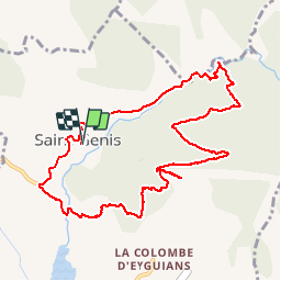
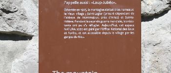
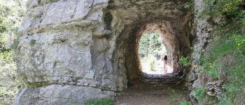
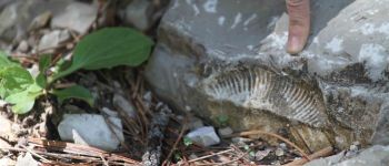
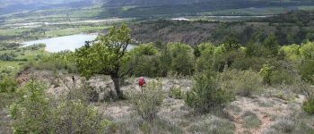
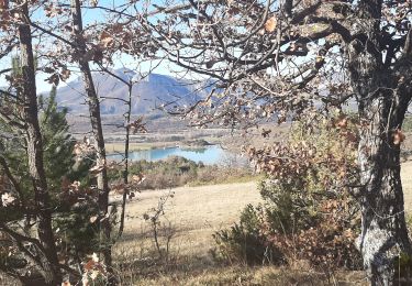
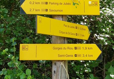
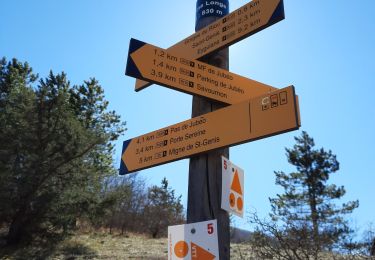
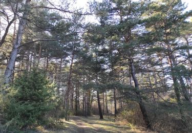
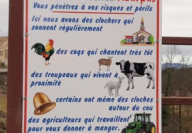
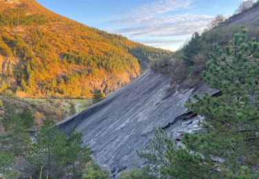
Randonnée à faire quand il ne fait pas trop chaud. Elle permet de découvrir les très belles gorges du Riou, et de s’y baigner. Les randonneurs les plus aguerris pourront continuer sur les crêtes de Saint Genis, qui offrent un magnifique panorama. Départ du minuscule et joli village de Saint-Genis ; parking en contrebas devant le cimetière, il faut ensuite remonter à pied pour récupérer le sentier. Nombreux fossiles sur le chemin (comme dans beaucoup d’endroits de la région d’ailleurs.) A la descente, le sentier est moins marqué, et parfois il est marqué mais il ne faut pas le suivre ! Donc bien suivre la carte. Tout en bas, on arrive au ruisseau qu’on traverse sur le pont et on rejoint le point de départ par la petite route.
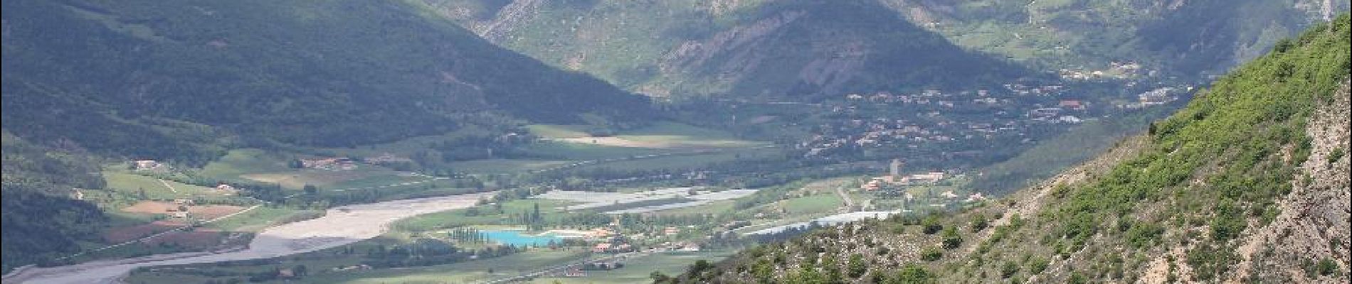
Si vous n’avez pas osé vous rafraîchir dans le ruisseau, vous pourrez, en reprenant la voiture, rejoindre le plan d’eau du Riou pour une baignade bien méritée. (buvette en été)
Puntos de interés
Localización
Comentarios
Excursiones cerca
![Excursión Senderismo Serres - Rocher de Beaumont - Photo](https://media.geolcdn.com/t/375/260/3fe601cb-d649-4fbf-81ae-1e708fafb3ae.jpg&format=jpg&maxdim=2)
![Senderismo Senderismo](https://static1.geolcdn.com/sitytour/trail-icons/101.png)
Senderismo
![](/images/other/stat-length.png)
![](https://static1.geolcdn.com/siteimages/upload/files/16400158638029165_repeat_loop_refresh_sync_direction_icon.png)
![Excursión A pie Garde-Colombe - Revuaire - Photo](https://media.geolcdn.com/t/375/260/45205769-c963-4aa4-aab1-0aabd1d8813a.jpg&format=jpg&maxdim=2)
![A pie A pie](https://static1.geolcdn.com/sitytour/trail-icons/100.png)
A pie
![](/images/other/stat-length.png)
![](https://static1.geolcdn.com/siteimages/upload/files/16400158638029165_repeat_loop_refresh_sync_direction_icon.png)
![Excursión Senderismo Garde-Colombe - SAINT GENIS Dep lac du Riou . Forte Sereine gorges du Riou o m s - Photo](https://media.geolcdn.com/t/375/260/56c7d25c-3fa5-4a10-abc1-3fc9cd71be7d.jpg&format=jpg&maxdim=2)
![Senderismo Senderismo](https://static1.geolcdn.com/sitytour/trail-icons/101.png)
Senderismo
![](/images/other/stat-length.png)
![](https://static1.geolcdn.com/siteimages/upload/files/16400158638029165_repeat_loop_refresh_sync_direction_icon.png)
![Excursión Senderismo Savournon - Reco Jubeo + 250 - Photo](https://media.geolcdn.com/t/375/260/3246d78b-af7a-40b7-a561-38804302bdf8.jpg&format=jpg&maxdim=2)
![Senderismo Senderismo](https://static1.geolcdn.com/sitytour/trail-icons/101.png)
Senderismo
![](/images/other/stat-length.png)
![](https://static1.geolcdn.com/siteimages/upload/files/16400158638029165_repeat_loop_refresh_sync_direction_icon.png)
![Excursión Senderismo Garde-Colombe - Le réduire.. gorge du riou - Photo](https://media.geolcdn.com/t/375/260/3c310a86-c1e4-42e9-b56e-cfcd18924e38.jpg&format=jpg&maxdim=2)
![Senderismo Senderismo](https://static1.geolcdn.com/sitytour/trail-icons/101.png)
Senderismo
![](/images/other/stat-length.png)
![](https://static1.geolcdn.com/siteimages/upload/files/16400158638029165_repeat_loop_refresh_sync_direction_icon.png)
![Excursión Senderismo Laragne-Montéglin - Vieil Arzellier/Vieil Eyguians.21/02/21. - Photo](https://media.geolcdn.com/t/375/260/addc1cc9-a190-4b69-a026-86524405f5ae.jpg&format=jpg&maxdim=2)
![Senderismo Senderismo](https://static1.geolcdn.com/sitytour/trail-icons/101.png)
Senderismo
![](/images/other/stat-length.png)
![](https://static1.geolcdn.com/siteimages/upload/files/16400158638029165_repeat_loop_refresh_sync_direction_icon.png)
![Excursión Senderismo Trescléoux - TRESCLEOUX Les granges de la montagne o s - Photo](https://media.geolcdn.com/t/375/260/d4139a1d-235b-4693-b7cd-01eb7b25235b.jpg&format=jpg&maxdim=2)
![Senderismo Senderismo](https://static1.geolcdn.com/sitytour/trail-icons/101.png)
Senderismo
![](/images/other/stat-length.png)
![](https://static1.geolcdn.com/siteimages/upload/files/16400158638029165_repeat_loop_refresh_sync_direction_icon.png)
![Excursión Bici de montaña Garde-Colombe - Pas du Colombier - Photo](https://media.geolcdn.com/t/375/260/6ef42281-a958-4b30-b76a-71b69ca13d3b.jpg&format=jpg&maxdim=2)
![Bici de montaña Bici de montaña](https://static1.geolcdn.com/sitytour/trail-icons/202.png)
Bici de montaña
![](/images/other/stat-length.png)
![](https://static1.geolcdn.com/siteimages/upload/files/16400158638029165_repeat_loop_refresh_sync_direction_icon.png)
![Excursión Senderismo Garde-Colombe - St-genis - Photo](https://media.geolcdn.com/t/375/260/82fd0028-f775-47ed-bf2c-39670ba12d33.jpg&format=jpg&maxdim=2)
![Senderismo Senderismo](https://static1.geolcdn.com/sitytour/trail-icons/101.png)
Senderismo
![](/images/other/stat-length.png)
![](https://static1.geolcdn.com/siteimages/upload/files/16400158638029165_repeat_loop_refresh_sync_direction_icon.png)