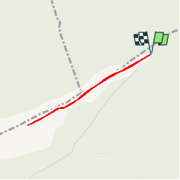
![](/images/other/stat-length.png)
![Excursión Senderismo Val-Buëch-Méouge - R31 La Montagne de Chabre - Photo](https://media.geolcdn.com/t/1900/400/ext.pjpeg?maxdim=2&url=https%3A%2F%2Fservices.sitytrail.com%2FGeolivesWS%2FDownloadMedia.ashx%3FTrailID%3D890890%26Media%3Db8749660-bf0d-4672-8fc8-3db6029b5cd6.jpg)
R31 La Montagne de Chabre
Camping Les Rives du Lac
Les Hautes Alpes à découvrir ! GUIDE+
![Longitud](/images/other/stat-length.png)
![Altitud máxima](https://static1.geolcdn.com/siteimages/upload/files/1508320355ic_sort_altitude_max_24dp.png)
![Desnivel positivo](https://static1.geolcdn.com/siteimages/upload/files/1508320355ic_sort_den_pos_24dp.png)
![Km-Effort](/images/other/stat-length.png)
![Altitud mínima](https://static1.geolcdn.com/siteimages/upload/files/1508320355ic_sort_altitude_min_24dp.png)
![Desnivel negativo](https://static1.geolcdn.com/siteimages/upload/files/1508320355ic_sort_den_neg_24dp.png)
![Boucle](https://static1.geolcdn.com/siteimages/upload/files/16400158638029165_repeat_loop_refresh_sync_direction_icon.png)
![Senderismo](https://static1.geolcdn.com/sitytour/trail-icons/101.png)
1h10
Dificultad : Muy fácil
![Escanee este código QR para abrir la excursión en la aplicación SityTrail](https://capi.geolives.com/qq0zvz2zws4bq2lad0pu/sitytour/trails/890890/qr.png?size=200)
Aplicación GPS de excursión GRATIS
A propósito
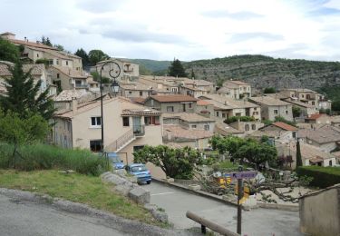
Ruta Senderismo de 2,8 km a descubrir en Provenza-Alpes-Costa Azul, Altos Alpes, Val-Buëch-Méouge. Esta ruta ha sido propuesta por Camping Les Rives du Lac.
Descripción
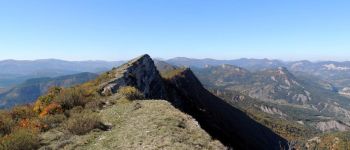
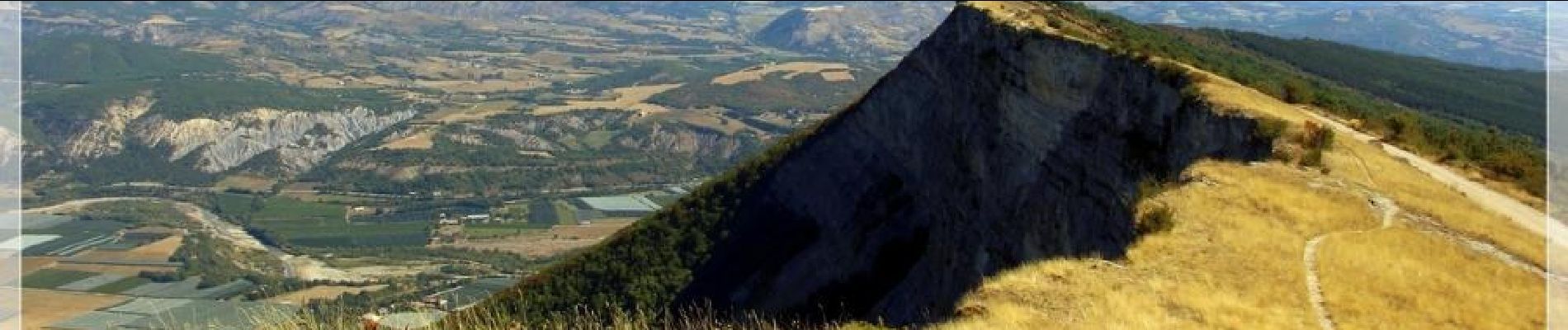
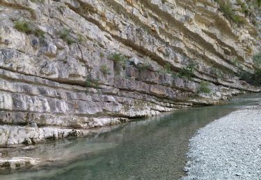
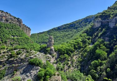
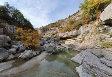
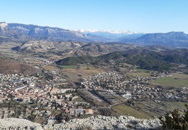
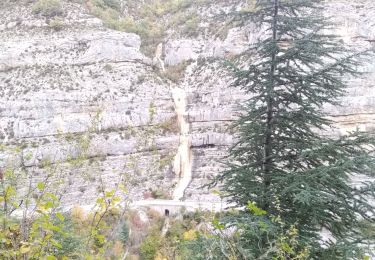
Une randonnée sans réel dénivelé qui vous permettra de profiter d’une belle vue et d’admirer deltaplanes et parapentes. A associer avec une baignade dans les gorges de la Méouge.
Localización
Comentarios
Excursiones cerca
![Excursión Senderismo Val-Buëch-Méouge - ANTONAVES, LES GORGES DE LA MEOUGE , ROCHER DU CHATEAU o s - Photo](https://media.geolcdn.com/t/375/260/1487f017-eb98-446f-a2df-e1c366eb0d18.jpg&format=jpg&maxdim=2)
![Senderismo Senderismo](https://static1.geolcdn.com/sitytour/trail-icons/101.png)
Senderismo
![](/images/other/stat-length.png)
![](https://static1.geolcdn.com/siteimages/upload/files/16400158638029165_repeat_loop_refresh_sync_direction_icon.png)
![Senderismo Senderismo](https://static1.geolcdn.com/sitytour/trail-icons/101.png)
Senderismo
![](/images/other/stat-length.png)
![](https://static1.geolcdn.com/siteimages/upload/files/16400158638029165_repeat_loop_refresh_sync_direction_icon.png)
![Excursión Senderismo Barret-sur-Méouge - 05 gorges meouge 03.08.23. semi aquatique un - Photo](https://media.geolcdn.com/t/375/260/f11f4fcf-0a2e-4abf-97b4-d5928fbacb3f.jpg&format=jpg&maxdim=2)
![Senderismo Senderismo](https://static1.geolcdn.com/sitytour/trail-icons/101.png)
Senderismo
![](/images/other/stat-length.png)
![](https://static1.geolcdn.com/siteimages/upload/files/16400158638029165_repeat_loop_refresh_sync_direction_icon.png)
![Excursión Senderismo Val-Buëch-Méouge - Gorges de la Méouge - Photo](https://media.geolcdn.com/t/375/260/b8f27dd7-d0a0-4777-bcd7-e07c51227ff7.jpg&format=jpg&maxdim=2)
![Senderismo Senderismo](https://static1.geolcdn.com/sitytour/trail-icons/101.png)
Senderismo
![](/images/other/stat-length.png)
![](https://static1.geolcdn.com/siteimages/upload/files/16400158638029165_repeat_loop_refresh_sync_direction_icon.png)
![Excursión Senderismo Val-Buëch-Méouge - Pic de Saint-Cyr - Photo](https://media.geolcdn.com/t/375/260/8e5f0bbe-387a-421f-b2fc-4a77ee6dc448.jpg&format=jpg&maxdim=2)
![Senderismo Senderismo](https://static1.geolcdn.com/sitytour/trail-icons/101.png)
Senderismo
![](/images/other/stat-length.png)
![](https://static1.geolcdn.com/siteimages/upload/files/16400158638029165_repeat_loop_refresh_sync_direction_icon.png)
![Excursión Senderismo Val-Buëch-Méouge - les gorges de la Méouge - Photo](https://media.geolcdn.com/t/375/260/59a674dc-fa24-4e7e-a052-fa4b43d50c90.jpg&format=jpg&maxdim=2)
![Senderismo Senderismo](https://static1.geolcdn.com/sitytour/trail-icons/101.png)
Senderismo
![](/images/other/stat-length.png)
![](https://static1.geolcdn.com/siteimages/upload/files/16400158638029165_repeat_loop_refresh_sync_direction_icon.png)
![Excursión Senderismo Val-Buëch-Méouge - SityTrail - PF-Antonaves - Les Gorges de la Méouge - Photo](https://media.geolcdn.com/t/375/260/ext.jpg?maxdim=2&url=https%3A%2F%2Fstatic1.geolcdn.com%2Fsiteimages%2Fupload%2Ffiles%2F1553511878bg_sport_marche.png)
![Senderismo Senderismo](https://static1.geolcdn.com/sitytour/trail-icons/101.png)
Senderismo
![](/images/other/stat-length.png)
![](https://static1.geolcdn.com/siteimages/upload/files/16400158638029165_repeat_loop_refresh_sync_direction_icon.png)
![Excursión Senderismo Val-Buëch-Méouge - CHATEAU NEUF DE CHABRE 05 . Piloubeau , les cretes de Chabre o s - Photo](https://media.geolcdn.com/t/375/260/ed0a937c-11c6-45f3-96a2-ba3aa0d6da41.jpg&format=jpg&maxdim=2)
![Senderismo Senderismo](https://static1.geolcdn.com/sitytour/trail-icons/101.png)
Senderismo
![](/images/other/stat-length.png)
![](https://static1.geolcdn.com/siteimages/upload/files/16400158638029165_repeat_loop_refresh_sync_direction_icon.png)
![Excursión Senderismo Val-Buëch-Méouge - le rocher du château, les gorges de Meouge - Photo](https://media.geolcdn.com/t/375/260/66634572-64d1-4210-8f44-d67187d51fd3.jpg&format=jpg&maxdim=2)
![Senderismo Senderismo](https://static1.geolcdn.com/sitytour/trail-icons/101.png)
Senderismo
![](/images/other/stat-length.png)
![](https://static1.geolcdn.com/siteimages/upload/files/16400158638029165_repeat_loop_refresh_sync_direction_icon.png)
randonnée très courte pour beaucoup de voiture