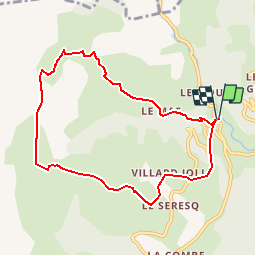
![](/images/other/stat-length.png)
![Excursión Senderismo Le Dévoluy - R25 Pierre Baudinard - Photo](https://media.geolcdn.com/t/1900/400/ext.pjpeg?maxdim=2&url=https%3A%2F%2Fservices.sitytrail.com%2FGeolivesWS%2FDownloadMedia.ashx%3FTrailID%3D890883%26Media%3Dee7710be-21b7-48d4-afcd-1270ef050a11.jpg)
R25 Pierre Baudinard
Camping Les Rives du Lac
Les Hautes Alpes à découvrir ! GUIDE+
![Longitud](/images/other/stat-length.png)
![Altitud máxima](https://static1.geolcdn.com/siteimages/upload/files/1508320355ic_sort_altitude_max_24dp.png)
![Desnivel positivo](https://static1.geolcdn.com/siteimages/upload/files/1508320355ic_sort_den_pos_24dp.png)
![Km-Effort](/images/other/stat-length.png)
![Altitud mínima](https://static1.geolcdn.com/siteimages/upload/files/1508320355ic_sort_altitude_min_24dp.png)
![Desnivel negativo](https://static1.geolcdn.com/siteimages/upload/files/1508320355ic_sort_den_neg_24dp.png)
![Boucle](https://static1.geolcdn.com/siteimages/upload/files/16400158638029165_repeat_loop_refresh_sync_direction_icon.png)
![Senderismo](https://static1.geolcdn.com/sitytour/trail-icons/101.png)
3h18
Dificultad : Medio
![Escanee este código QR para abrir la excursión en la aplicación SityTrail](https://capi.geolives.com/qq0zvz2zws4bq2lad0pu/sitytour/trails/890883/qr.png?size=200)
Aplicación GPS de excursión GRATIS
A propósito
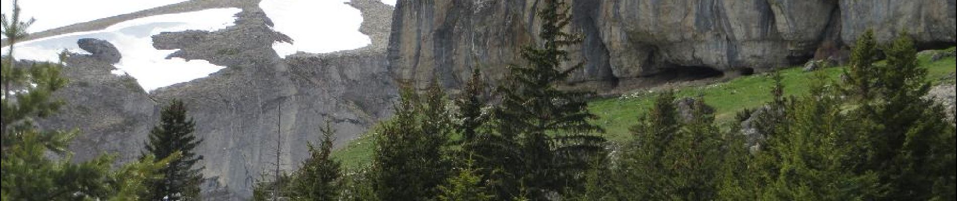
Ruta Senderismo de 8,6 km a descubrir en Provenza-Alpes-Costa Azul, Altos Alpes, Le Dévoluy. Esta ruta ha sido propuesta por Camping Les Rives du Lac.
Descripción
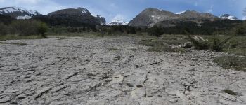
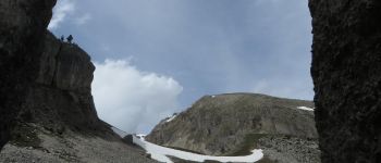
Randonnée très sauvage et très variée : vous traverserez de magnifiques forêts de hêtres, puis les impressionnants chaos de blocs (à côté de la cabane de Pierre Baudinard) avant de longer des affleurements de grès peu communs. Magnifique vue sur le Dévoluy mais aussi sur les massifs plus à l'EST (Ecrins)
Localización
Comentarios
Excursiones cerca
![Excursión Senderismo Le Dévoluy - R29 La crete des Beaumes - Photo](https://media.geolcdn.com/t/375/260/ext.jpg?maxdim=2&url=https%3A%2F%2Fservices.sitytrail.com%2FGeolivesWS%2FDownloadMedia.ashx%3FTrailID%3D890888%26Media%3Da26bb0d1-74cd-455a-a17c-3db0bb6ab810.jpg)
![Senderismo Senderismo](https://static1.geolcdn.com/sitytour/trail-icons/101.png)
Senderismo
![](/images/other/stat-length.png)
![](https://static1.geolcdn.com/siteimages/upload/files/16400158638029165_repeat_loop_refresh_sync_direction_icon.png)
![Excursión Senderismo Le Dévoluy - Pierre Baudinard - Photo](https://media.geolcdn.com/t/375/260/dea0799c-94e0-4315-9166-bde984af0e12.jpg&format=jpg&maxdim=2)
![Senderismo Senderismo](https://static1.geolcdn.com/sitytour/trail-icons/101.png)
Senderismo
![](/images/other/stat-length.png)
![](https://static1.geolcdn.com/siteimages/upload/files/16400158638029165_repeat_loop_refresh_sync_direction_icon.png)
![Excursión Esquí de fondo Le Dévoluy - L'Aiglière et serre de cheval - Photo](https://media.geolcdn.com/t/375/260/41c3a76b-99fe-4aab-8880-7263880f8ffd.jpg&format=jpg&maxdim=2)
![Esquí de fondo Esquí de fondo](https://static1.geolcdn.com/sitytour/trail-icons/503.png)
Esquí de fondo
![](/images/other/stat-length.png)
![](https://static1.geolcdn.com/siteimages/upload/files/16400158638029165_repeat_loop_refresh_sync_direction_icon.png)
![Excursión Esquí de fondo Le Dévoluy - col sou la tête d'oriol et crête de la clape - Photo](https://media.geolcdn.com/t/375/260/9ecbcea7-5655-4fbe-b488-b03ce3d93479.jpg&format=jpg&maxdim=2)
![Esquí de fondo Esquí de fondo](https://static1.geolcdn.com/sitytour/trail-icons/503.png)
Esquí de fondo
![](/images/other/stat-length.png)
![](https://static1.geolcdn.com/siteimages/upload/files/16400158638029165_repeat_loop_refresh_sync_direction_icon.png)
![Excursión Esquí de fondo Le Dévoluy - Le Nid - Photo](https://media.geolcdn.com/t/375/260/5bab7be5-98e2-4d6d-b137-94826649cb1f.jpg&format=jpg&maxdim=2)
![Esquí de fondo Esquí de fondo](https://static1.geolcdn.com/sitytour/trail-icons/503.png)
Esquí de fondo
![](/images/other/stat-length.png)
![](https://static1.geolcdn.com/siteimages/upload/files/16400158638029165_repeat_loop_refresh_sync_direction_icon.png)
![Excursión Esquí de fondo Le Dévoluy - le pas de la cloche. - Photo](https://media.geolcdn.com/t/375/260/6f4d97b3-6792-482f-be87-1058e226e432.jpg&format=jpg&maxdim=2)
![Esquí de fondo Esquí de fondo](https://static1.geolcdn.com/sitytour/trail-icons/503.png)
Esquí de fondo
![](/images/other/stat-length.png)
![](https://static1.geolcdn.com/siteimages/upload/files/16400158638029165_repeat_loop_refresh_sync_direction_icon.png)
![Excursión Senderismo Le Dévoluy - Le Faraut. Pic pierroux - Photo](https://media.geolcdn.com/t/375/260/f70077a3-127b-4a4c-a1bb-36cf90d608f0.jpg&format=jpg&maxdim=2)
![Senderismo Senderismo](https://static1.geolcdn.com/sitytour/trail-icons/101.png)
Senderismo
![](/images/other/stat-length.png)
![](https://static1.geolcdn.com/siteimages/upload/files/16400158638029165_repeat_loop_refresh_sync_direction_icon.png)
![Excursión Senderismo Pellafol - R44 Le Bénitier - Photo](https://media.geolcdn.com/t/375/260/c09c5294-f23e-4ece-8780-88830b0ef2c5.jpg&format=jpg&maxdim=2)
![Senderismo Senderismo](https://static1.geolcdn.com/sitytour/trail-icons/101.png)
Senderismo
![](/images/other/stat-length.png)
![](https://static1.geolcdn.com/siteimages/upload/files/16400158638029165_repeat_loop_refresh_sync_direction_icon.png)
![Excursión Senderismo Pellafol - R43 Les Gillardes - Photo](https://media.geolcdn.com/t/375/260/ext.jpg?maxdim=2&url=https%3A%2F%2Fservices.sitytrail.com%2FGeolivesWS%2FDownloadMedia.ashx%3FTrailID%3D890901%26Media%3D34932a86-a06f-4702-8669-5c5d0130cca7.jpg)
![Senderismo Senderismo](https://static1.geolcdn.com/sitytour/trail-icons/101.png)
Senderismo
![](/images/other/stat-length.png)
![](https://static1.geolcdn.com/siteimages/upload/files/16400158638029165_repeat_loop_refresh_sync_direction_icon.png)