![](/images/other/stat-length.png)
![Excursión Senderismo Bagnoles-de-l'Orne-Normandie - Bagnoles-Couterne aux confins de la Normandie - Photo](https://media.geolcdn.com/t/1900/400/ext.pjpeg?maxdim=2&url=https%3A%2F%2Fstatic1.geolcdn.com%2Fsiteimages%2Fupload%2Ffiles%2F1553511878bg_sport_marche.png)
Bagnoles-Couterne aux confins de la Normandie
toporient
Usuario
![Longitud](/images/other/stat-length.png)
Longitud
13,8 km
![Altitud máxima](https://static1.geolcdn.com/siteimages/upload/files/1508320355ic_sort_altitude_max_24dp.png)
Altitud máxima
229 m
![Desnivel positivo](https://static1.geolcdn.com/siteimages/upload/files/1508320355ic_sort_den_pos_24dp.png)
Desnivel positivo
233 m
![Km-Effort](/images/other/stat-length.png)
Km-Effort
16,9 km
![Altitud mínima](https://static1.geolcdn.com/siteimages/upload/files/1508320355ic_sort_altitude_min_24dp.png)
Altitud mínima
121 m
![Desnivel negativo](https://static1.geolcdn.com/siteimages/upload/files/1508320355ic_sort_den_neg_24dp.png)
Desnivel negativo
233 m
![Boucle](https://static1.geolcdn.com/siteimages/upload/files/16400158638029165_repeat_loop_refresh_sync_direction_icon.png)
Boucle
Sí
Fecha de creación :
2018-04-17 14:57:18.246
Última modificación :
2018-04-17 14:57:18.246
![Senderismo](https://static1.geolcdn.com/sitytour/trail-icons/101.png)
3h39
Dificultad : Medio
![Escanee este código QR para abrir la excursión en la aplicación SityTrail](https://capi.geolives.com/qq0zvz2zws4bq2lad0pu/sitytour/trails/878271/qr.png?size=200)
Aplicación GPS de excursión GRATIS
A propósito
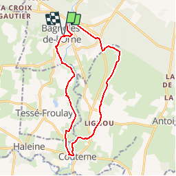
Ruta Senderismo de 13,8 km a descubrir en Normandía, Orne, Bagnoles-de-l'Orne-Normandie. Esta ruta ha sido propuesta por toporient.
Descripción
Du château, le circuit passe par le lac puis par le vieux Bagnoles. Il rejoint ensuite le GRP jusqu'à ND de Lignou et Couterne puis revient par la vallée de la Vée et le vieux Tessé pour terminer au château.
Localización
País:
France
Región :
Normandía
Departamento/provincia :
Orne
Municipio :
Bagnoles-de-l'Orne-Normandie
Localidad:
Bagnoles-de-l'Orne
Salida:(Dec)
Salida:(UTM)
690249 ; 5381036 (30U) N.
Comentarios
Excursiones cerca
![Excursión A pie Rives-d'Andaine - Sentier des Templiers - Photo](https://media.geolcdn.com/t/375/260/ext.jpg?maxdim=2&url=https%3A%2F%2Fmedia.geolcdn.com%2Ff%2F7f8f2913-590f-4c31-b4e9-64954dd46906.jpeg)
![A pie A pie](https://static1.geolcdn.com/sitytour/trail-icons/100.png)
Sentier des Templiers
A pie
Fácil
Rives-d'Andaine,
Normandía,
Orne,
France
![](/images/other/stat-length.png)
4,9 km | 6,2 km-effort
1h 23min
![](https://static1.geolcdn.com/siteimages/upload/files/16400158638029165_repeat_loop_refresh_sync_direction_icon.png)
No
![Excursión Senderismo Bagnoles-de-l'Orne-Normandie - Saint Ortaire - Photo](https://media.geolcdn.com/t/375/260/ext.jpg?maxdim=2&url=https%3A%2F%2Fstatic1.geolcdn.com%2Fsiteimages%2Fupload%2Ffiles%2F1553511878bg_sport_marche.png)
![Senderismo Senderismo](https://static1.geolcdn.com/sitytour/trail-icons/101.png)
Saint Ortaire
Senderismo
Difícil
(1)
Bagnoles-de-l'Orne-Normandie,
Normandía,
Orne,
France
![](/images/other/stat-length.png)
5,5 km | 6,9 km-effort
1h 39min
![](https://static1.geolcdn.com/siteimages/upload/files/16400158638029165_repeat_loop_refresh_sync_direction_icon.png)
Sí
![Excursión Senderismo Bagnoles-de-l'Orne-Normandie - Forêt d'Andaine - Photo](https://media.geolcdn.com/t/375/260/ext.jpg?maxdim=2&url=https%3A%2F%2Fmedia.geolcdn.com%2Ff%2F4445009f-5e34-4cf0-9270-1184d385e215.jpg)
![Senderismo Senderismo](https://static1.geolcdn.com/sitytour/trail-icons/101.png)
Forêt d'Andaine
Senderismo
Fácil
Bagnoles-de-l'Orne-Normandie,
Normandía,
Orne,
France
![](/images/other/stat-length.png)
3,6 km | 4,2 km-effort
2h 0min
![](https://static1.geolcdn.com/siteimages/upload/files/16400158638029165_repeat_loop_refresh_sync_direction_icon.png)
No
![Excursión A pie Bagnoles-de-l'Orne-Normandie - Les Arbres remarquables de Bagnoles-de-l'Orne - Photo](https://media.geolcdn.com/t/375/260/ext.jpg?maxdim=2&url=https%3A%2F%2Fmedia.geolcdn.com%2Ff%2F3f5af4f6-b5c2-468d-a381-1ea1dcd7f8d4.jpeg)
![A pie A pie](https://static1.geolcdn.com/sitytour/trail-icons/100.png)
Les Arbres remarquables de Bagnoles-de-l'Orne
A pie
Fácil
Bagnoles-de-l'Orne-Normandie,
Normandía,
Orne,
France
![](/images/other/stat-length.png)
7,7 km | 9 km-effort
2h 2min
![](https://static1.geolcdn.com/siteimages/upload/files/16400158638029165_repeat_loop_refresh_sync_direction_icon.png)
Sí
![Excursión A pie Bagnoles-de-l'Orne-Normandie - Bagnoles-de-l'Orne - Photo](https://media.geolcdn.com/t/375/260/ext.jpg?maxdim=2&url=https%3A%2F%2Fmedia.geolcdn.com%2Ff%2F352c0479-80dd-4a7d-ade5-52d7e1895bb3.jpeg)
![A pie A pie](https://static1.geolcdn.com/sitytour/trail-icons/100.png)
Bagnoles-de-l'Orne
A pie
Fácil
Bagnoles-de-l'Orne-Normandie,
Normandía,
Orne,
France
![](/images/other/stat-length.png)
8,2 km | 9,7 km-effort
2h 11min
![](https://static1.geolcdn.com/siteimages/upload/files/16400158638029165_repeat_loop_refresh_sync_direction_icon.png)
No
![Excursión A pie La Ferté-Macé - Circuit des Bornes Cavalières - Photo](https://media.geolcdn.com/t/375/260/ext.jpg?maxdim=2&url=https%3A%2F%2Fmedia.geolcdn.com%2Ff%2Fae4572a0-be41-42e4-9cb7-abcf5f5905ac.jpeg)
![A pie A pie](https://static1.geolcdn.com/sitytour/trail-icons/100.png)
Circuit des Bornes Cavalières
A pie
Fácil
La Ferté-Macé,
Normandía,
Orne,
France
![](/images/other/stat-length.png)
8 km | 9,5 km-effort
2h 10min
![](https://static1.geolcdn.com/siteimages/upload/files/16400158638029165_repeat_loop_refresh_sync_direction_icon.png)
No
![Excursión Bicicleta híbrida Bagnoles-de-l'Orne-Normandie - bagnoles de l'ore - Photo](https://media.geolcdn.com/t/375/260/ext.jpg?maxdim=2&url=https%3A%2F%2Fmedia.geolcdn.com%2Ff%2F4eea9336-edc2-458e-9d5f-3a5eced18dc8.jpg)
![Bicicleta híbrida Bicicleta híbrida](https://static1.geolcdn.com/sitytour/trail-icons/203.png)
bagnoles de l'ore
Bicicleta híbrida
Fácil
Bagnoles-de-l'Orne-Normandie,
Normandía,
Orne,
France
![](/images/other/stat-length.png)
18,6 km | 22 km-effort
1h 41min
![](https://static1.geolcdn.com/siteimages/upload/files/16400158638029165_repeat_loop_refresh_sync_direction_icon.png)
Sí
![Excursión Senderismo Magny-le-Désert - Andaines - Villiers - Photo](https://media.geolcdn.com/t/375/260/ext.jpg?maxdim=2&url=https%3A%2F%2Fstatic1.geolcdn.com%2Fsiteimages%2Fupload%2Ffiles%2F1553511878bg_sport_marche.png)
![Senderismo Senderismo](https://static1.geolcdn.com/sitytour/trail-icons/101.png)
Andaines - Villiers
Senderismo
Medio
(1)
Magny-le-Désert,
Normandía,
Orne,
France
![](/images/other/stat-length.png)
10,6 km | 13,6 km-effort
2h 36min
![](https://static1.geolcdn.com/siteimages/upload/files/16400158638029165_repeat_loop_refresh_sync_direction_icon.png)
Sí
![Excursión Senderismo Bagnoles-de-l'Orne-Normandie - Bagnoles de l' orne - Photo](https://media.geolcdn.com/t/375/260/ext.jpg?maxdim=2&url=https%3A%2F%2Fmedia.geolcdn.com%2Ff%2Ffa0660f3-37d7-48ea-8a93-ad724fc5fdf8.jpg)
![Senderismo Senderismo](https://static1.geolcdn.com/sitytour/trail-icons/101.png)
Bagnoles de l' orne
Senderismo
Muy fácil
Bagnoles-de-l'Orne-Normandie,
Normandía,
Orne,
France
![](/images/other/stat-length.png)
4,8 km | 6,1 km-effort
1h 49min
![](https://static1.geolcdn.com/siteimages/upload/files/16400158638029165_repeat_loop_refresh_sync_direction_icon.png)
Sí