![](/images/other/stat-length.png)
![Excursión Senderismo Machecoul-Saint-Même - L'abbaye de la Chaume - Photo](https://media.geolcdn.com/t/1900/400/ext.pjpeg?maxdim=2&url=https%3A%2F%2Fstatic1.geolcdn.com%2Fsiteimages%2Fupload%2Ffiles%2F1553511878bg_sport_marche.png)
L'abbaye de la Chaume
neoroll44
Usuario
![Longitud](/images/other/stat-length.png)
![Altitud máxima](https://static1.geolcdn.com/siteimages/upload/files/1508320355ic_sort_altitude_max_24dp.png)
![Desnivel positivo](https://static1.geolcdn.com/siteimages/upload/files/1508320355ic_sort_den_pos_24dp.png)
![Km-Effort](/images/other/stat-length.png)
![Altitud mínima](https://static1.geolcdn.com/siteimages/upload/files/1508320355ic_sort_altitude_min_24dp.png)
![Desnivel negativo](https://static1.geolcdn.com/siteimages/upload/files/1508320355ic_sort_den_neg_24dp.png)
![Boucle](https://static1.geolcdn.com/siteimages/upload/files/16400158638029165_repeat_loop_refresh_sync_direction_icon.png)
![Senderismo](https://static1.geolcdn.com/sitytour/trail-icons/101.png)
1h45
Dificultad : Medio
![Escanee este código QR para abrir la excursión en la aplicación SityTrail](https://capi.geolives.com/qq0zvz2zws4bq2lad0pu/sitytour/trails/868426/qr.png?size=200)
Aplicación GPS de excursión GRATIS
A propósito
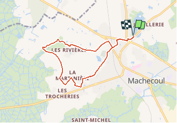
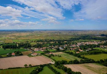
Ruta Senderismo de 7,4 km a descubrir en Países del Loira, Loira-Atlántico, Machecoul-Saint-Même. Esta ruta ha sido propuesta por neoroll44.
Descripción
Se garer au parking du Grand Étang.
Dirigez-vous vers le rond-point en utilisant le piste cyclable et piétonne. Traversez-le en utilisant les passages protégés. Virez à droite et longez la D13 par la gauche (partie piétonne).
Tournez à gauche et suivez à gauche le chemin qui mène dans le lotissement. Coupez l'Avenue de la Rochejaquelin pour arriver Avenue Hoche. Virez à droite, traversez la route tout droit et arrivez sur la Rue de Pornic.
Tournez à droite et aussitôt à gauche Boulevard de la Chapelle après avoir franchi le passage à niveau. Ensuite, allez toujours tout droit jusqu'à l’hippodrome.
Au Stop, continuez tout droit (légèrement à droite), passez entre les deux maisons, et prenez aussitôt à droite. Suivez le petit sentier et arrivez sur la route (Avenue de l'Hippodrome).
Faites un rapide droite-gauche et continuez sur la route qui effectue plus loin un virage à gauche à angle droit.
Au niveaux des maisons, tournez à droite et longez les habitations. Au bout du chemin, virez à droite sur 150m puis à gauche et filez tout droit. Tournez ensuite à gauche jusqu’à la maison en pierre au milieu du champ et virez alors à droite à 90°.
Prenez à droite à la sortie des cultures maraîchères, puis bifurquez légèrement à gauche et suivez le chemin de terre jusqu’au bout.
Arrivé au lieu-dit les Basses Noës, aussitôt après la maison, prenez à droite le petit chemin entre la haie et les tenues maraîchères. Suivez ce chemin jusqu'au mur face à vous et prenez à droite. Ignorez un chemin sur la gauche et poursuivez jusqu'au lieu-dit les Rivières.
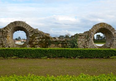
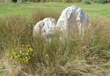
Prenez à gauche, passez entre les maisons et suivez le chemin jusqu’aux ruines de l'Abbaye de la Chaume.
Arrivé au niveau de l'Abbaye de la Chaume, bifurquez légèrement à gauche et suivez le chemin jusqu'à la route (Rue de Pornic). Tournez à droite et rejoignez le passage à niveau.
Après celui-ci, tournez à gauche et rejoignez le Grand Étang dans le sens retour (D/A).
Localización
Comentarios
Excursiones cerca
![Excursión A pie Villeneuve-en-Retz - Les roseaux et le bocage - Photo](https://media.geolcdn.com/t/375/260/c8f3ca36-d092-4724-80d2-115c2709d19a.jpeg&format=jpg&maxdim=2)
![A pie A pie](https://static1.geolcdn.com/sitytour/trail-icons/100.png)
A pie
![](/images/other/stat-length.png)
![](https://static1.geolcdn.com/siteimages/upload/files/16400158638029165_repeat_loop_refresh_sync_direction_icon.png)
![Excursión A pie Machecoul-Saint-Même - Le Pont de l'Essart - Photo](https://media.geolcdn.com/t/375/260/3d5c89df-7e8c-492b-aace-8df832dbe27e.jpeg&format=jpg&maxdim=2)
![A pie A pie](https://static1.geolcdn.com/sitytour/trail-icons/100.png)
A pie
![](/images/other/stat-length.png)
![](https://static1.geolcdn.com/siteimages/upload/files/16400158638029165_repeat_loop_refresh_sync_direction_icon.png)
![Excursión Senderismo Machecoul-Saint-Même - La Chèvre Pendue - Photo](https://media.geolcdn.com/t/375/260/ext.jpg?maxdim=2&url=https%3A%2F%2Fservices.sitytrail.com%2FGeolivesWS%2FDownloadMedia.ashx%3FTrailID%3D745028%26Media%3D57ac4cbc-791f-4bcf-b754-ca8f4e729928.jpg)
![Senderismo Senderismo](https://static1.geolcdn.com/sitytour/trail-icons/101.png)
Senderismo
![](/images/other/stat-length.png)
![](https://static1.geolcdn.com/siteimages/upload/files/16400158638029165_repeat_loop_refresh_sync_direction_icon.png)
![Excursión A pie Villeneuve-en-Retz - Les Ajoncs - Photo](https://media.geolcdn.com/t/375/260/a75d8add-319e-469f-abc7-7f7c6664ec76.jpeg&format=jpg&maxdim=2)
![A pie A pie](https://static1.geolcdn.com/sitytour/trail-icons/100.png)
A pie
![](/images/other/stat-length.png)
![](https://static1.geolcdn.com/siteimages/upload/files/16400158638029165_repeat_loop_refresh_sync_direction_icon.png)
![Excursión A pie Machecoul-Saint-Même - 149 - Photo](https://media.geolcdn.com/t/375/260/052f4a3a-37af-4033-a9fa-8577c6e689e6.jpeg&format=jpg&maxdim=2)
![A pie A pie](https://static1.geolcdn.com/sitytour/trail-icons/100.png)
A pie
![](/images/other/stat-length.png)
![](https://static1.geolcdn.com/siteimages/upload/files/16400158638029165_repeat_loop_refresh_sync_direction_icon.png)
![Excursión Senderismo Villeneuve-en-Retz - SityTrail - fresnay - Photo](https://media.geolcdn.com/t/375/260/a65b5444-e3fd-4a12-8f7e-8d055c6b1adf.jpg&format=jpg&maxdim=2)
![Senderismo Senderismo](https://static1.geolcdn.com/sitytour/trail-icons/101.png)
Senderismo
![](/images/other/stat-length.png)
![](https://static1.geolcdn.com/siteimages/upload/files/16400158638029165_repeat_loop_refresh_sync_direction_icon.png)
![Excursión Senderismo Villeneuve-en-Retz - Villeneuve-en-Retz Randonnée - Photo](https://media.geolcdn.com/t/375/260/ext.jpg?maxdim=2&url=https%3A%2F%2Fstatic1.geolcdn.com%2Fsiteimages%2Fupload%2Ffiles%2F1553511878bg_sport_marche.png)
![Senderismo Senderismo](https://static1.geolcdn.com/sitytour/trail-icons/101.png)
Senderismo
![](/images/other/stat-length.png)
![](https://static1.geolcdn.com/siteimages/upload/files/16400158638029165_repeat_loop_refresh_sync_direction_icon.png)
![Excursión Senderismo Villeneuve-en-Retz - Le Marais de Fresnay - Photo](https://media.geolcdn.com/t/375/260/ext.jpg?maxdim=2&url=https%3A%2F%2Fstatic1.geolcdn.com%2Fsiteimages%2Fupload%2Ffiles%2F1553511878bg_sport_marche.png)
![Senderismo Senderismo](https://static1.geolcdn.com/sitytour/trail-icons/101.png)
Senderismo
![](/images/other/stat-length.png)
![](https://static1.geolcdn.com/siteimages/upload/files/16400158638029165_repeat_loop_refresh_sync_direction_icon.png)
![Excursión A pie Machecoul-Saint-Même - Forêt de Machecoul - Photo](https://media.geolcdn.com/t/375/260/ext.jpg?maxdim=2&url=https%3A%2F%2Fstatic1.geolcdn.com%2Fsiteimages%2Fupload%2Ffiles%2F1545311037marcheuse_200dpi.jpg)
![A pie A pie](https://static1.geolcdn.com/sitytour/trail-icons/100.png)
A pie
![](/images/other/stat-length.png)
![](https://static1.geolcdn.com/siteimages/upload/files/16400158638029165_repeat_loop_refresh_sync_direction_icon.png)