![](/images/other/stat-length.png)
![Excursión Senderismo Lachapelle-aux-Pots - Lachapelle aux pots - Photo](https://media.geolcdn.com/t/1900/400/ext.pjpeg?maxdim=2&url=https%3A%2F%2Fstatic1.geolcdn.com%2Fsiteimages%2Fupload%2Ffiles%2F1553511878bg_sport_marche.png)
Lachapelle aux pots
Marie-Claire-mcp
Usuario
![Longitud](/images/other/stat-length.png)
![Altitud máxima](https://static1.geolcdn.com/siteimages/upload/files/1508320355ic_sort_altitude_max_24dp.png)
![Desnivel positivo](https://static1.geolcdn.com/siteimages/upload/files/1508320355ic_sort_den_pos_24dp.png)
![Km-Effort](/images/other/stat-length.png)
![Altitud mínima](https://static1.geolcdn.com/siteimages/upload/files/1508320355ic_sort_altitude_min_24dp.png)
![Desnivel negativo](https://static1.geolcdn.com/siteimages/upload/files/1508320355ic_sort_den_neg_24dp.png)
![Boucle](https://static1.geolcdn.com/siteimages/upload/files/16400158638029165_repeat_loop_refresh_sync_direction_icon.png)
![Senderismo](https://static1.geolcdn.com/sitytour/trail-icons/101.png)
2h37
Dificultad : Fácil
![Escanee este código QR para abrir la excursión en la aplicación SityTrail](https://capi.geolives.com/qq0zvz2zws4bq2lad0pu/sitytour/trails/863784/qr.png?size=200)
Aplicación GPS de excursión GRATIS
A propósito
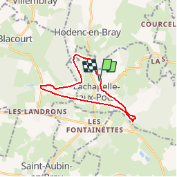
Ruta Senderismo de 10,2 km a descubrir en Alta Francia, Oise, Lachapelle-aux-Pots. Esta ruta ha sido propuesta por Marie-Claire-mcp.
Descripción
Lachapelle aux pots, rue de la Gare - Voie verte jusqu'à Vivier Danger - route à gauche puis chemin à gauche au virage jusqu'à Lachapelle aux pots (rue de la ferme)puis rue de Gerberoy - continuer dans le bois jusqu'au Rutoire - Traverser la route et au bout du chemin à gauche puis direction Blacourt à droite et à la route à droite puis La Boissière et chemin noir à gauche - La Fontaine Modet à gauche - puis Voie verte à gauche jusqu'à Lachapelle aux pots
Localización
Comentarios
Excursiones cerca
![Excursión Bici de montaña Lachapelle-aux-Pots - ACTIVE LOG 003 - Photo](https://media.geolcdn.com/t/375/260/ext.jpg?maxdim=2&url=https%3A%2F%2Fstatic1.geolcdn.com%2Fsiteimages%2Fupload%2Ffiles%2F1524743154velo.jpg)
![Bici de montaña Bici de montaña](https://static1.geolcdn.com/sitytour/trail-icons/202.png)
Bici de montaña
![](/images/other/stat-length.png)
![](https://static1.geolcdn.com/siteimages/upload/files/16400158638029165_repeat_loop_refresh_sync_direction_icon.png)
![Excursión Bici de montaña Pierrefitte-en-Beauvaisis - Grand tour - Photo](https://media.geolcdn.com/t/375/260/ext.jpg?maxdim=2&url=https%3A%2F%2Fstatic1.geolcdn.com%2Fsiteimages%2Fupload%2Ffiles%2F1524743154velo.jpg)
![Bici de montaña Bici de montaña](https://static1.geolcdn.com/sitytour/trail-icons/202.png)
Bici de montaña
![](/images/other/stat-length.png)
![](https://static1.geolcdn.com/siteimages/upload/files/16400158638029165_repeat_loop_refresh_sync_direction_icon.png)
![Excursión Senderismo Senantes - Senantes - Photo](https://media.geolcdn.com/t/375/260/f6921859-4933-4cab-b0ea-93545be25606.jpg&format=jpg&maxdim=2)
![Senderismo Senderismo](https://static1.geolcdn.com/sitytour/trail-icons/101.png)
![Excursión Senderismo Savignies - savignies - Photo](https://media.geolcdn.com/t/375/260/ext.jpg?maxdim=2&url=https%3A%2F%2Fstatic1.geolcdn.com%2Fsiteimages%2Fupload%2Ffiles%2F1553511878bg_sport_marche.png)
![Senderismo Senderismo](https://static1.geolcdn.com/sitytour/trail-icons/101.png)
![Excursión Senderismo Lachapelle-aux-Pots - Lachapelle-aux-pots - Héricourt - La Frénoye - Armentières - Photo](https://media.geolcdn.com/t/375/260/ext.jpg?maxdim=2&url=https%3A%2F%2Fstatic1.geolcdn.com%2Fsiteimages%2Fupload%2Ffiles%2F1553511878bg_sport_marche.png)
![Senderismo Senderismo](https://static1.geolcdn.com/sitytour/trail-icons/101.png)
Senderismo
![](/images/other/stat-length.png)
![](https://static1.geolcdn.com/siteimages/upload/files/16400158638029165_repeat_loop_refresh_sync_direction_icon.png)
![Excursión Senderismo Lachapelle-aux-Pots - Lachapelle aux pots - Armentières 11 km - Photo](https://media.geolcdn.com/t/375/260/ext.jpg?maxdim=2&url=https%3A%2F%2Fstatic1.geolcdn.com%2Fsiteimages%2Fupload%2Ffiles%2F1553511878bg_sport_marche.png)
![Senderismo Senderismo](https://static1.geolcdn.com/sitytour/trail-icons/101.png)
Senderismo
![](/images/other/stat-length.png)
![](https://static1.geolcdn.com/siteimages/upload/files/16400158638029165_repeat_loop_refresh_sync_direction_icon.png)
![Excursión Senderismo Lachapelle-aux-Pots - Lachapelle aux Pots - Rando santé 1 - Photo](https://media.geolcdn.com/t/375/260/ext.jpg?maxdim=2&url=https%3A%2F%2Fstatic1.geolcdn.com%2Fsiteimages%2Fupload%2Ffiles%2F1553511878bg_sport_marche.png)
![Senderismo Senderismo](https://static1.geolcdn.com/sitytour/trail-icons/101.png)
Senderismo
![](/images/other/stat-length.png)
![](https://static1.geolcdn.com/siteimages/upload/files/16400158638029165_repeat_loop_refresh_sync_direction_icon.png)
![Excursión Senderismo Lachapelle-aux-Pots - Lachapelle-aux-Pots - autour de la Crapaudière vers 2 - Photo](https://media.geolcdn.com/t/375/260/ext.jpg?maxdim=2&url=https%3A%2F%2Fstatic1.geolcdn.com%2Fsiteimages%2Fupload%2Ffiles%2F1553511878bg_sport_marche.png)
![Senderismo Senderismo](https://static1.geolcdn.com/sitytour/trail-icons/101.png)
Senderismo
![](/images/other/stat-length.png)
![](https://static1.geolcdn.com/siteimages/upload/files/16400158638029165_repeat_loop_refresh_sync_direction_icon.png)
![Excursión Senderismo Lachapelle-aux-Pots - Lachapelle-aux-Pots - autour de la Crapaudière - Photo](https://media.geolcdn.com/t/375/260/ext.jpg?maxdim=2&url=https%3A%2F%2Fstatic1.geolcdn.com%2Fsiteimages%2Fupload%2Ffiles%2F1553511878bg_sport_marche.png)
![Senderismo Senderismo](https://static1.geolcdn.com/sitytour/trail-icons/101.png)
Senderismo
![](/images/other/stat-length.png)
![](https://static1.geolcdn.com/siteimages/upload/files/16400158638029165_repeat_loop_refresh_sync_direction_icon.png)