![](/images/other/stat-length.png)
![Excursión Senderismo La Réorthe - Ma Réorthon 2017 - Photo](https://media.geolcdn.com/t/1900/400/ext.pjpeg?maxdim=2&url=https%3A%2F%2Fstatic1.geolcdn.com%2Fsiteimages%2Fupload%2Ffiles%2F1553511878bg_sport_marche.png)
Ma Réorthon 2017
cath310
Usuario
![Longitud](/images/other/stat-length.png)
Longitud
25 km
![Altitud máxima](https://static1.geolcdn.com/siteimages/upload/files/1508320355ic_sort_altitude_max_24dp.png)
Altitud máxima
92 m
![Desnivel positivo](https://static1.geolcdn.com/siteimages/upload/files/1508320355ic_sort_den_pos_24dp.png)
Desnivel positivo
332 m
![Km-Effort](/images/other/stat-length.png)
Km-Effort
30 km
![Altitud mínima](https://static1.geolcdn.com/siteimages/upload/files/1508320355ic_sort_altitude_min_24dp.png)
Altitud mínima
15 m
![Desnivel negativo](https://static1.geolcdn.com/siteimages/upload/files/1508320355ic_sort_den_neg_24dp.png)
Desnivel negativo
332 m
![Boucle](https://static1.geolcdn.com/siteimages/upload/files/16400158638029165_repeat_loop_refresh_sync_direction_icon.png)
Boucle
Sí
Fecha de creación :
2018-04-17 12:37:27.861
Última modificación :
2018-04-17 12:37:27.861
![Senderismo](https://static1.geolcdn.com/sitytour/trail-icons/101.png)
6h25
Dificultad : Medio
![Escanee este código QR para abrir la excursión en la aplicación SityTrail](https://capi.geolives.com/qq0zvz2zws4bq2lad0pu/sitytour/trails/860529/qr.png?size=200)
Aplicación GPS de excursión GRATIS
A propósito
Ruta Senderismo de 25 km a descubrir en Países del Loira, Vandea, La Réorthe. Esta ruta ha sido propuesta por cath310.
Descripción
Vendée : marche populaire LA REORTHE
D/R : Féole
dans le Bocage, se déroule en forêt, dans les coteaux de la vallée du Lay et dans une campagne fortement vallonnée
Localización
País:
France
Región :
Países del Loira
Departamento/provincia :
Vandea
Municipio :
La Réorthe
Localidad:
Unknown
Salida:(Dec)
Salida:(UTM)
650318 ; 5162337 (30T) N.
Comentarios
Excursiones cerca
![Excursión Senderismo Sainte-Hermine - sainte Hermine - la rehorte - Photo](https://media.geolcdn.com/t/375/260/ext.jpg?maxdim=2&url=https%3A%2F%2Fstatic1.geolcdn.com%2Fsiteimages%2Fupload%2Ffiles%2F1553511878bg_sport_marche.png)
![Senderismo Senderismo](https://static1.geolcdn.com/sitytour/trail-icons/101.png)
sainte Hermine - la rehorte
Senderismo
Muy fácil
(2)
Sainte-Hermine,
Países del Loira,
Vandea,
France
![](/images/other/stat-length.png)
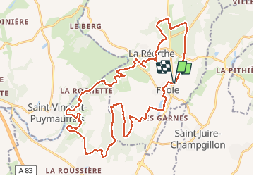
14,6 km | 16,9 km-effort
3h 50min
![](https://static1.geolcdn.com/siteimages/upload/files/16400158638029165_repeat_loop_refresh_sync_direction_icon.png)
Sí
![Excursión Senderismo Sainte-Hermine - rando sur le chemin des sages - Photo](https://media.geolcdn.com/t/375/260/f7a99b87-6fbe-4929-ae57-043edd038b7f.jpg&format=jpg&maxdim=2)
![Senderismo Senderismo](https://static1.geolcdn.com/sitytour/trail-icons/101.png)
rando sur le chemin des sages
Senderismo
Muy fácil
(1)
Sainte-Hermine,
Países del Loira,
Vandea,
France
![](/images/other/stat-length.png)
6,9 km | 7,7 km-effort
1h 30min
![](https://static1.geolcdn.com/siteimages/upload/files/16400158638029165_repeat_loop_refresh_sync_direction_icon.png)
Sí
![Excursión Senderismo Sainte-Hermine - sainte Hermine -bois de e - Photo](https://media.geolcdn.com/t/375/260/ext.jpg?maxdim=2&url=https%3A%2F%2Fstatic1.geolcdn.com%2Fsiteimages%2Fupload%2Ffiles%2F1553511878bg_sport_marche.png)
![Senderismo Senderismo](https://static1.geolcdn.com/sitytour/trail-icons/101.png)
sainte Hermine -bois de e
Senderismo
Muy fácil
Sainte-Hermine,
Países del Loira,
Vandea,
France
![](/images/other/stat-length.png)
10,7 km | 12,2 km-effort
2h 46min
![](https://static1.geolcdn.com/siteimages/upload/files/16400158638029165_repeat_loop_refresh_sync_direction_icon.png)
Sí
![Excursión Senderismo Bournezeau - St-Vi cent Puymaufrais - Photo](https://media.geolcdn.com/t/375/260/ext.jpg?maxdim=2&url=https%3A%2F%2Fstatic1.geolcdn.com%2Fsiteimages%2Fupload%2Ffiles%2F1553511878bg_sport_marche.png)
![Senderismo Senderismo](https://static1.geolcdn.com/sitytour/trail-icons/101.png)
St-Vi cent Puymaufrais
Senderismo
Muy fácil
Bournezeau,
Países del Loira,
Vandea,
France
![](/images/other/stat-length.png)
9,8 km | 12 km-effort
2h 37min
![](https://static1.geolcdn.com/siteimages/upload/files/16400158638029165_repeat_loop_refresh_sync_direction_icon.png)
Sí
![Excursión Senderismo La Réorthe - La Rheorthe - Photo](https://media.geolcdn.com/t/375/260/ext.jpg?maxdim=2&url=https%3A%2F%2Fstatic1.geolcdn.com%2Fsiteimages%2Fupload%2Ffiles%2F1553511878bg_sport_marche.png)
![Senderismo Senderismo](https://static1.geolcdn.com/sitytour/trail-icons/101.png)
La Rheorthe
Senderismo
Medio
La Réorthe,
Países del Loira,
Vandea,
France
![](/images/other/stat-length.png)
8,1 km | 10,1 km-effort
2h 11min
![](https://static1.geolcdn.com/siteimages/upload/files/16400158638029165_repeat_loop_refresh_sync_direction_icon.png)
Sí
![Excursión Senderismo Saint-Juire-Champgillon - St Juire - Champgillon (3) - Photo](https://media.geolcdn.com/t/375/260/ext.jpg?maxdim=2&url=https%3A%2F%2Fstatic1.geolcdn.com%2Fsiteimages%2Fupload%2Ffiles%2F1553511878bg_sport_marche.png)
![Senderismo Senderismo](https://static1.geolcdn.com/sitytour/trail-icons/101.png)
St Juire - Champgillon (3)
Senderismo
Fácil
Saint-Juire-Champgillon,
Países del Loira,
Vandea,
France
![](/images/other/stat-length.png)
7,3 km | 8,4 km-effort
2h 27min
![](https://static1.geolcdn.com/siteimages/upload/files/16400158638029165_repeat_loop_refresh_sync_direction_icon.png)
Sí
![Excursión Senderismo Saint-Juire-Champgillon - St Juire - Champgillon (2) - Photo](https://media.geolcdn.com/t/375/260/ext.jpg?maxdim=2&url=https%3A%2F%2Fstatic1.geolcdn.com%2Fsiteimages%2Fupload%2Ffiles%2F1553511878bg_sport_marche.png)
![Senderismo Senderismo](https://static1.geolcdn.com/sitytour/trail-icons/101.png)
St Juire - Champgillon (2)
Senderismo
Fácil
Saint-Juire-Champgillon,
Países del Loira,
Vandea,
France
![](/images/other/stat-length.png)
15,3 km | 17,4 km-effort
2h 27min
![](https://static1.geolcdn.com/siteimages/upload/files/16400158638029165_repeat_loop_refresh_sync_direction_icon.png)
Sí
![Excursión Senderismo Saint-Juire-Champgillon - St Juire - Champgillon - Photo](https://media.geolcdn.com/t/375/260/ext.jpg?maxdim=2&url=https%3A%2F%2Fstatic1.geolcdn.com%2Fsiteimages%2Fupload%2Ffiles%2F1553511878bg_sport_marche.png)
![Senderismo Senderismo](https://static1.geolcdn.com/sitytour/trail-icons/101.png)
St Juire - Champgillon
Senderismo
Fácil
Saint-Juire-Champgillon,
Países del Loira,
Vandea,
France
![](/images/other/stat-length.png)
10 km | 11,2 km-effort
2h 27min
![](https://static1.geolcdn.com/siteimages/upload/files/16400158638029165_repeat_loop_refresh_sync_direction_icon.png)
Sí
![Excursión Senderismo Saint-Martin-Lars-en-Sainte-Hermine - Pays de Ste Hermine-3 - Photo](https://media.geolcdn.com/t/375/260/ext.jpg?maxdim=2&url=https%3A%2F%2Fstatic1.geolcdn.com%2Fsiteimages%2Fupload%2Ffiles%2F1553511878bg_sport_marche.png)
![Senderismo Senderismo](https://static1.geolcdn.com/sitytour/trail-icons/101.png)
Pays de Ste Hermine-3
Senderismo
Muy fácil
Saint-Martin-Lars-en-Sainte-Hermine,
Países del Loira,
Vandea,
France
![](/images/other/stat-length.png)
17,8 km | 21 km-effort
4h 31min
![](https://static1.geolcdn.com/siteimages/upload/files/16400158638029165_repeat_loop_refresh_sync_direction_icon.png)
Sí