![](/images/other/stat-length.png)
![Excursión Senderismo Anthisnes - ANTHISNES - Boucle du Vinâve - Photo](https://media.geolcdn.com/t/1900/400/ext.pjpeg?maxdim=2&url=https%3A%2F%2Fstatic1.geolcdn.com%2Fsiteimages%2Fupload%2Ffiles%2F1553511878bg_sport_marche.png)
ANTHISNES - Boucle du Vinâve
jhack159
Usuario
![Longitud](/images/other/stat-length.png)
![Altitud máxima](https://static1.geolcdn.com/siteimages/upload/files/1508320355ic_sort_altitude_max_24dp.png)
![Desnivel positivo](https://static1.geolcdn.com/siteimages/upload/files/1508320355ic_sort_den_pos_24dp.png)
![Km-Effort](/images/other/stat-length.png)
![Altitud mínima](https://static1.geolcdn.com/siteimages/upload/files/1508320355ic_sort_altitude_min_24dp.png)
![Desnivel negativo](https://static1.geolcdn.com/siteimages/upload/files/1508320355ic_sort_den_neg_24dp.png)
![Boucle](https://static1.geolcdn.com/siteimages/upload/files/16400158638029165_repeat_loop_refresh_sync_direction_icon.png)
![Baliza](https://services.sitytrail.com/GeolivesWS/DownloadMedia.ashx?TrailID=856776&Media=balise.png)
![Senderismo](https://static1.geolcdn.com/sitytour/trail-icons/101.png)
2h59
Dificultad : Fácil
![Escanee este código QR para abrir la excursión en la aplicación SityTrail](https://capi.geolives.com/qq0zvz2zws4bq2lad0pu/sitytour/trails/856776/qr.png?size=200)
Aplicación GPS de excursión GRATIS
A propósito
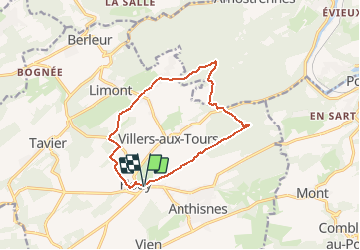
Ruta Senderismo de 11,1 km a descubrir en Valonia, Lieja, Anthisnes. Esta ruta ha sido propuesta por jhack159.
Descripción
Ce parcours bocager et forestier joint plusieurs villages d’Anthisnes en recoupant sans cesse les tiges et chavées, caractéristiques du paysage condruzien. Hody, Villers-aux-Tours, Targnon, Hestreux, la Ferme du Sart... sont les jalons de ce parcours au relief accidenté. Vinâve, lieu-dit de Hody, est le nom liégeois signifiant vignoble. Un vignoble aurait-il jadis couvert le tige d’Hody ?
Localización
Comentarios
Excursiones cerca
![Excursión Senderismo Esneux - Esneux bois du mary - Photo](https://media.geolcdn.com/t/375/260/71c77441-f9b7-4220-bb0a-fbf9c3317653.jpg&format=jpg&maxdim=2)
![Senderismo Senderismo](https://static1.geolcdn.com/sitytour/trail-icons/101.png)
Senderismo
![](/images/other/stat-length.png)
![](https://static1.geolcdn.com/siteimages/upload/files/16400158638029165_repeat_loop_refresh_sync_direction_icon.png)
![Excursión Senderismo Anthisnes - RB-Lg-18_Tavier - Photo](https://media.geolcdn.com/t/375/260/ext.jpg?maxdim=2&url=https%3A%2F%2Fservices.sitytrail.com%2FGeolivesWS%2FDownloadMedia.ashx%3FTrailID%3D400569%26Media%3D8137f08d-271c-4dcb-b2bd-96adf6706999.jpg)
![Senderismo Senderismo](https://static1.geolcdn.com/sitytour/trail-icons/101.png)
Senderismo
![](/images/other/stat-length.png)
![](https://static1.geolcdn.com/siteimages/upload/files/16400158638029165_repeat_loop_refresh_sync_direction_icon.png)
![Excursión Senderismo Esneux - 2024-07-24_09h57m26_itin-raire-1-esneux - Photo](https://media.geolcdn.com/t/375/260/a932a506-f892-4455-93af-64f2fda79c4c.jpg&format=jpg&maxdim=2)
![Senderismo Senderismo](https://static1.geolcdn.com/sitytour/trail-icons/101.png)
Senderismo
![](/images/other/stat-length.png)
![](https://static1.geolcdn.com/siteimages/upload/files/16400158638029165_repeat_loop_refresh_sync_direction_icon.png)
![Excursión Senderismo Comblain-au-Pont - 2021-04-04_15h31m49_Cirkwi-Autour_de_Comblain-au-Pont_-_Promenade_9___Grotte_-_Raideux_-_Anthisnes_-_Les_Stepennes_-_Géromont - Photo](https://media.geolcdn.com/t/375/260/edfd852c-0012-45e6-9a23-c8c8cd48cf84.jpg&format=jpg&maxdim=2)
![Senderismo Senderismo](https://static1.geolcdn.com/sitytour/trail-icons/101.png)
Senderismo
![](/images/other/stat-length.png)
![](https://static1.geolcdn.com/siteimages/upload/files/16400158638029165_repeat_loop_refresh_sync_direction_icon.png)
![Excursión Senderismo Anthisnes - Anthines - AS03 - Boucle de Tolumont - Losange Bleu - Photo](https://media.geolcdn.com/t/375/260/a3413dfd-3361-4d9b-b91d-7efec18943a3.jpg&format=jpg&maxdim=2)
![Senderismo Senderismo](https://static1.geolcdn.com/sitytour/trail-icons/101.png)
Senderismo
![](/images/other/stat-length.png)
![](https://static1.geolcdn.com/siteimages/upload/files/16400158638029165_repeat_loop_refresh_sync_direction_icon.png)
![Excursión A pie Anthisnes - AS03 Boucle de Tolumont - Photo](https://media.geolcdn.com/t/375/260/bb3be3cf-eddc-4622-8273-ff9944f2671c.jpg&format=jpg&maxdim=2)
![A pie A pie](https://static1.geolcdn.com/sitytour/trail-icons/100.png)
A pie
![](/images/other/stat-length.png)
![](https://static1.geolcdn.com/siteimages/upload/files/16400158638029165_repeat_loop_refresh_sync_direction_icon.png)
![Excursión Senderismo Esneux - arboretum parc mary . vallée pisserotte . carrière . ry d'oneux - Photo](https://media.geolcdn.com/t/375/260/ext.jpg?maxdim=2&url=https%3A%2F%2Fservices.sitytrail.com%2FGeolivesWS%2FDownloadMedia.ashx%3FTrailID%3D949883%26Media%3Dfix__20180423172523.jpg)
![Senderismo Senderismo](https://static1.geolcdn.com/sitytour/trail-icons/101.png)
Senderismo
![](/images/other/stat-length.png)
![](https://static1.geolcdn.com/siteimages/upload/files/16400158638029165_repeat_loop_refresh_sync_direction_icon.png)
![Excursión Senderismo Esneux - autour du parc du Mary - variante - Photo](https://media.geolcdn.com/t/375/260/6aeeb14f-cb94-42ed-9f4c-8fd35fd8d259.jpg&format=jpg&maxdim=2)
![Senderismo Senderismo](https://static1.geolcdn.com/sitytour/trail-icons/101.png)
Senderismo
![](/images/other/stat-length.png)
![](https://static1.geolcdn.com/siteimages/upload/files/16400158638029165_repeat_loop_refresh_sync_direction_icon.png)
![Excursión Senderismo Esneux - Test pédestre 31 aout - Photo](https://media.geolcdn.com/t/375/260/0a40204f-ad60-4dd7-a6d5-ef776cc49ca2.jpg&format=jpg&maxdim=2)
![Senderismo Senderismo](https://static1.geolcdn.com/sitytour/trail-icons/101.png)
Senderismo
![](/images/other/stat-length.png)
![](https://static1.geolcdn.com/siteimages/upload/files/16400158638029165_repeat_loop_refresh_sync_direction_icon.png)