![](/images/other/stat-length.png)
![Excursión Otra actividad Unknown - Eglise Agia Marina - Mont Zas (Zeus), Naxos - Photo](https://media.geolcdn.com/t/1900/400/ext.pjpeg?maxdim=2&url=https%3A%2F%2Fservices.sitytrail.com%2FGeolivesWS%2FDownloadMedia.ashx%3FTrailID%3D847693%26Media%3Dfix__20171017115603.jpg)
Eglise Agia Marina - Mont Zas (Zeus), Naxos
Albanjan
Usuario
![Longitud](/images/other/stat-length.png)
Longitud
4,3 km
![Altitud máxima](https://static1.geolcdn.com/siteimages/upload/files/1508320355ic_sort_altitude_max_24dp.png)
Altitud máxima
891 m
![Desnivel positivo](https://static1.geolcdn.com/siteimages/upload/files/1508320355ic_sort_den_pos_24dp.png)
Desnivel positivo
296 m
![Km-Effort](/images/other/stat-length.png)
Km-Effort
8,2 km
![Altitud mínima](https://static1.geolcdn.com/siteimages/upload/files/1508320355ic_sort_altitude_min_24dp.png)
Altitud mínima
591 m
![Desnivel negativo](https://static1.geolcdn.com/siteimages/upload/files/1508320355ic_sort_den_neg_24dp.png)
Desnivel negativo
296 m
![Boucle](https://static1.geolcdn.com/siteimages/upload/files/16400158638029165_repeat_loop_refresh_sync_direction_icon.png)
Boucle
Sí
Fecha de creación :
2018-04-17 10:59:41.871
Última modificación :
2018-04-17 10:59:41.871
![Otra actividad](https://static1.geolcdn.com/sitytour/trail-icons/900.png)
2h22
Dificultad : Desconocido
![Escanee este código QR para abrir la excursión en la aplicación SityTrail](https://capi.geolives.com/qq0zvz2zws4bq2lad0pu/sitytour/trails/847693/qr.png?size=200)
Aplicación GPS de excursión GRATIS
A propósito
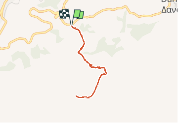
Ruta Otra actividad de 4,3 km a descubrir en Αποκεντρωμένη Διοίκηση Αιγαίου, Περιφερειακή Ενότητα Νάξου. Esta ruta ha sido propuesta por Albanjan.
Descripción
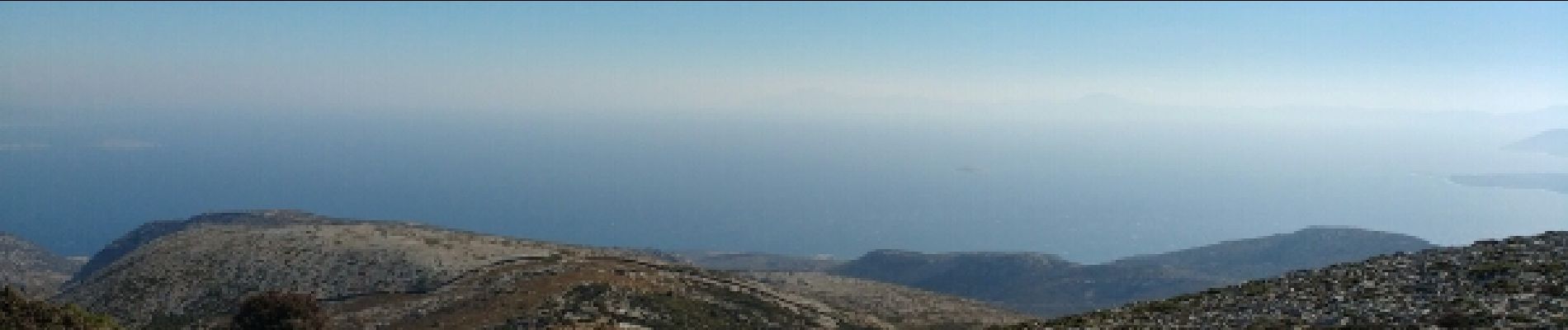
Assension du Mont Zas (point culminant de Naxos ET des Cyclades) depuis la chapelle de Sainte Marina. Une vue superbe sur toutes les Cyclades et une montée plutôt facile
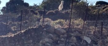
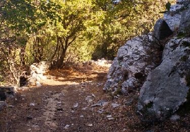
Localización
País:
Greece
Región :
Αποκεντρωμένη Διοίκηση Αιγαίου
Departamento/provincia :
Περιφερειακή Ενότητα Νάξου
Municipio :
Unknown
Localidad:
Unknown
Salida:(Dec)
Salida:(UTM)
367244 ; 4100873 (35S) N.
Comentarios
Excursiones cerca
![Excursión Senderismo - Apiranthos - Eglise de St Jean le théologien - Photo](https://media.geolcdn.com/t/375/260/ext.jpg?maxdim=2&url=https%3A%2F%2Fservices.sitytrail.com%2FGeolivesWS%2FDownloadMedia.ashx%3FTrailID%3D852793%26Media%3Dfix__20171027122504.jpg)
![Senderismo Senderismo](https://static1.geolcdn.com/sitytour/trail-icons/101.png)
Apiranthos - Eglise de St Jean le théologien
Senderismo
Fácil
,
Αποκεντρωμένη Διοίκηση Αιγαίου,
Περιφερειακή Ενότητα Νάξου,
Greece
![](/images/other/stat-length.png)
1,3 km | 1,7 km-effort
34min
![](https://static1.geolcdn.com/siteimages/upload/files/16400158638029165_repeat_loop_refresh_sync_direction_icon.png)
No
![Excursión Senderismo - mont zeus - Photo](https://media.geolcdn.com/t/375/260/ext.jpg?maxdim=2&url=https%3A%2F%2Fstatic1.geolcdn.com%2Fsiteimages%2Fupload%2Ffiles%2F1553511878bg_sport_marche.png)
![Senderismo Senderismo](https://static1.geolcdn.com/sitytour/trail-icons/101.png)
mont zeus
Senderismo
Difícil
,
Αποκεντρωμένη Διοίκηση Αιγαίου,
Περιφερειακή Ενότητα Νάξου,
Greece
![](/images/other/stat-length.png)
8 km | 15,8 km-effort
9h 0min
![](https://static1.geolcdn.com/siteimages/upload/files/16400158638029165_repeat_loop_refresh_sync_direction_icon.png)
No
![Excursión Senderismo - chalki - Photo](https://media.geolcdn.com/t/375/260/ext.jpg?maxdim=2&url=https%3A%2F%2Fstatic1.geolcdn.com%2Fsiteimages%2Fupload%2Ffiles%2F1553511878bg_sport_marche.png)
![Senderismo Senderismo](https://static1.geolcdn.com/sitytour/trail-icons/101.png)
chalki
Senderismo
Medio
,
Αποκεντρωμένη Διοίκηση Αιγαίου,
Περιφερειακή Ενότητα Νάξου,
Greece
![](/images/other/stat-length.png)
7,1 km | 10 km-effort
3h 8min
![](https://static1.geolcdn.com/siteimages/upload/files/16400158638029165_repeat_loop_refresh_sync_direction_icon.png)
No
![Excursión Senderismo - Mont Zeus. - Photo](https://media.geolcdn.com/t/375/260/ext.jpg?maxdim=2&url=https%3A%2F%2Fstatic1.geolcdn.com%2Fsiteimages%2Fupload%2Ffiles%2F1553511878bg_sport_marche.png)
![Senderismo Senderismo](https://static1.geolcdn.com/sitytour/trail-icons/101.png)
Mont Zeus.
Senderismo
Difícil
,
Αποκεντρωμένη Διοίκηση Αιγαίου,
Περιφερειακή Ενότητα Νάξου,
Greece
![](/images/other/stat-length.png)
12,9 km | 22 km-effort
4h 7min
![](https://static1.geolcdn.com/siteimages/upload/files/16400158638029165_repeat_loop_refresh_sync_direction_icon.png)
No
![Excursión Senderismo - Naxos_muller_Verlag_Apiranthos_Moutsouna_aller - Photo](https://media.geolcdn.com/t/375/260/ext.jpg?maxdim=2&url=https%3A%2F%2Fstatic1.geolcdn.com%2Fsiteimages%2Fupload%2Ffiles%2F1553511878bg_sport_marche.png)
![Senderismo Senderismo](https://static1.geolcdn.com/sitytour/trail-icons/101.png)
Naxos_muller_Verlag_Apiranthos_Moutsouna_aller
Senderismo
Medio
,
Αποκεντρωμένη Διοίκηση Αιγαίου,
Περιφερειακή Ενότητα Νάξου,
Greece
![](/images/other/stat-length.png)
12,2 km | 15,8 km-effort
3h 11min
![](https://static1.geolcdn.com/siteimages/upload/files/16400158638029165_repeat_loop_refresh_sync_direction_icon.png)
No
![Excursión Senderismo - Naxos_muller_Verlag_Apiranthos_Fotodhotis_Filoti_aller - Photo](https://media.geolcdn.com/t/375/260/ext.jpg?maxdim=2&url=https%3A%2F%2Fstatic1.geolcdn.com%2Fsiteimages%2Fupload%2Ffiles%2F1553511878bg_sport_marche.png)
![Senderismo Senderismo](https://static1.geolcdn.com/sitytour/trail-icons/101.png)
Naxos_muller_Verlag_Apiranthos_Fotodhotis_Filoti_aller
Senderismo
Muy fácil
,
Αποκεντρωμένη Διοίκηση Αιγαίου,
Περιφερειακή Ενότητα Νάξου,
Greece
![](/images/other/stat-length.png)
6,9 km | 10,3 km-effort
2h 5min
![](https://static1.geolcdn.com/siteimages/upload/files/16400158638029165_repeat_loop_refresh_sync_direction_icon.png)
No
![Excursión Senderismo - apeiranthos filoti par photodhotis - Photo](https://media.geolcdn.com/t/375/260/ext.jpg?maxdim=2&url=https%3A%2F%2Fstatic1.geolcdn.com%2Fsiteimages%2Fupload%2Ffiles%2F1553511878bg_sport_marche.png)
![Senderismo Senderismo](https://static1.geolcdn.com/sitytour/trail-icons/101.png)
apeiranthos filoti par photodhotis
Senderismo
Medio
,
Αποκεντρωμένη Διοίκηση Αιγαίου,
Περιφερειακή Ενότητα Νάξου,
Greece
![](/images/other/stat-length.png)
8,7 km | 12,6 km-effort
2h 37min
![](https://static1.geolcdn.com/siteimages/upload/files/16400158638029165_repeat_loop_refresh_sync_direction_icon.png)
No
![Excursión Senderismo - filoti apeiranthos par le moulin - Photo](https://media.geolcdn.com/t/375/260/ext.jpg?maxdim=2&url=https%3A%2F%2Fstatic1.geolcdn.com%2Fsiteimages%2Fupload%2Ffiles%2F1553511878bg_sport_marche.png)
![Senderismo Senderismo](https://static1.geolcdn.com/sitytour/trail-icons/101.png)
filoti apeiranthos par le moulin
Senderismo
Medio
,
Αποκεντρωμένη Διοίκηση Αιγαίου,
Περιφερειακή Ενότητα Νάξου,
Greece
![](/images/other/stat-length.png)
7 km | 11,7 km-effort
2h 35min
![](https://static1.geolcdn.com/siteimages/upload/files/16400158638029165_repeat_loop_refresh_sync_direction_icon.png)
No
![Excursión Senderismo - Filoti Mont Zeus Agia Marina - Photo](https://media.geolcdn.com/t/375/260/ext.jpg?maxdim=2&url=https%3A%2F%2Fstatic1.geolcdn.com%2Fsiteimages%2Fupload%2Ffiles%2F1553511878bg_sport_marche.png)
![Senderismo Senderismo](https://static1.geolcdn.com/sitytour/trail-icons/101.png)
Filoti Mont Zeus Agia Marina
Senderismo
Difícil
,
Αποκεντρωμένη Διοίκηση Αιγαίου,
Περιφερειακή Ενότητα Νάξου,
Greece
![](/images/other/stat-length.png)
9 km | 17,3 km-effort
3h 30min
![](https://static1.geolcdn.com/siteimages/upload/files/16400158638029165_repeat_loop_refresh_sync_direction_icon.png)
Sí