![](/images/other/stat-length.png)
![Excursión Senderismo Sers - Col d'Aoube - Photo](https://media.geolcdn.com/t/1900/400/ext.pjpeg?maxdim=2&url=https%3A%2F%2Fstatic1.geolcdn.com%2Fsiteimages%2Fupload%2Ffiles%2F1553511878bg_sport_marche.png)
Col d'Aoube
jysc238
Usuario
![Longitud](/images/other/stat-length.png)
Longitud
11,5 km
![Altitud máxima](https://static1.geolcdn.com/siteimages/upload/files/1508320355ic_sort_altitude_max_24dp.png)
Altitud máxima
2410 m
![Desnivel positivo](https://static1.geolcdn.com/siteimages/upload/files/1508320355ic_sort_den_pos_24dp.png)
Desnivel positivo
672 m
![Km-Effort](/images/other/stat-length.png)
Km-Effort
20 km
![Altitud mínima](https://static1.geolcdn.com/siteimages/upload/files/1508320355ic_sort_altitude_min_24dp.png)
Altitud mínima
1934 m
![Desnivel negativo](https://static1.geolcdn.com/siteimages/upload/files/1508320355ic_sort_den_neg_24dp.png)
Desnivel negativo
670 m
![Boucle](https://static1.geolcdn.com/siteimages/upload/files/16400158638029165_repeat_loop_refresh_sync_direction_icon.png)
Boucle
Sí
Fecha de creación :
2018-04-17 00:07:23.471
Última modificación :
2018-04-17 00:07:23.471
![Senderismo](https://static1.geolcdn.com/sitytour/trail-icons/101.png)
5h40
Dificultad : Medio
![Escanee este código QR para abrir la excursión en la aplicación SityTrail](https://capi.geolives.com/qq0zvz2zws4bq2lad0pu/sitytour/trails/840664/qr.png?size=200)
Aplicación GPS de excursión GRATIS
A propósito
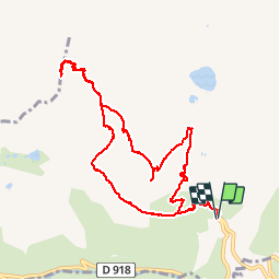
Ruta Senderismo de 11,5 km a descubrir en Occitania, Altos-Pirineos, Sers. Esta ruta ha sido propuesta por jysc238.
Descripción
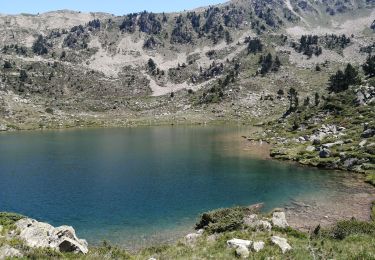
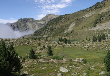
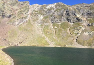
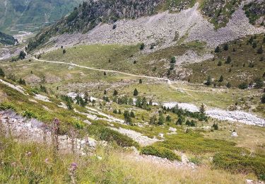
Départ depuis le virage de Coume l'ayse en-dessous du col du Tourmalet. On passe par le lac d'Aouda avant d'attaquer lamontée au col d'Aoube, où on découvre les lacs vert et bleu en dessous. Retour par le col de la Bonida.
Localización
País:
France
Región :
Occitania
Departamento/provincia :
Altos-Pirineos
Municipio :
Sers
Localidad:
Unknown
Salida:(Dec)
Salida:(UTM)
266301 ; 4755144 (31T) N.
Comentarios
Excursiones cerca
![Excursión Senderismo Barèges - Pic des Trois Conseillers - Photo](https://media.geolcdn.com/t/375/260/ext.jpg?maxdim=2&url=https%3A%2F%2Fservices.sitytrail.com%2FGeolivesWS%2FDownloadMedia.ashx%3FTrailID%3D172698%26Media%3D14081_6.jpg)
![Senderismo Senderismo](https://static1.geolcdn.com/sitytour/trail-icons/101.png)
Pic des Trois Conseillers
Senderismo
Muy difícil
(1)
Barèges,
Occitania,
Altos-Pirineos,
France
![](/images/other/stat-length.png)
16 km | 34 km-effort
9h 0min
![](https://static1.geolcdn.com/siteimages/upload/files/16400158638029165_repeat_loop_refresh_sync_direction_icon.png)
Sí
![Excursión Senderismo Barèges - Pic de Madamète en boucle par les lacs - Photo](https://media.geolcdn.com/t/375/260/ext.jpg?maxdim=2&url=https%3A%2F%2Fservices.sitytrail.com%2FGeolivesWS%2FDownloadMedia.ashx%3FTrailID%3D107077%26Media%3D11899_5.jpg)
![Senderismo Senderismo](https://static1.geolcdn.com/sitytour/trail-icons/101.png)
Pic de Madamète en boucle par les lacs
Senderismo
Difícil
(1)
Barèges,
Occitania,
Altos-Pirineos,
France
![](/images/other/stat-length.png)
21 km | 40 km-effort
9h 0min
![](https://static1.geolcdn.com/siteimages/upload/files/16400158638029165_repeat_loop_refresh_sync_direction_icon.png)
Sí
![Excursión Paseo ecuestre Sers - Plateau d’Aoube par la cabane d’Aoube - Photo](https://media.geolcdn.com/t/375/260/d0a193ac-ccc5-435d-ab72-b3f01c20ee9b.jpg&format=jpg&maxdim=2)
![Paseo ecuestre Paseo ecuestre](https://static1.geolcdn.com/sitytour/trail-icons/301.png)
Plateau d’Aoube par la cabane d’Aoube
Paseo ecuestre
Fácil
Sers,
Occitania,
Altos-Pirineos,
France
![](/images/other/stat-length.png)
7,4 km | 15,1 km-effort
4h 43min
![](https://static1.geolcdn.com/siteimages/upload/files/16400158638029165_repeat_loop_refresh_sync_direction_icon.png)
Sí
![Excursión Senderismo Bagnères-de-Bigorre - tourmalet G2 heit - Photo](https://media.geolcdn.com/t/375/260/8cd371a0-9f70-473d-b4f9-0ddefaeeb150.jpg&format=jpg&maxdim=2)
![Senderismo Senderismo](https://static1.geolcdn.com/sitytour/trail-icons/101.png)
tourmalet G2 heit
Senderismo
Muy fácil
Bagnères-de-Bigorre,
Occitania,
Altos-Pirineos,
France
![](/images/other/stat-length.png)
5,5 km | 11,6 km-effort
6h 37min
![](https://static1.geolcdn.com/siteimages/upload/files/16400158638029165_repeat_loop_refresh_sync_direction_icon.png)
Sí
![Excursión Senderismo Barèges - En boucle, Grand Tourmalet- Aygues Cluses-Col de Madamète- Lac Dets Coubous. - Photo](https://media.geolcdn.com/t/375/260/ext.jpg?maxdim=2&url=https%3A%2F%2Fstatic1.geolcdn.com%2Fsiteimages%2Fupload%2Ffiles%2F1553511878bg_sport_marche.png)
![Senderismo Senderismo](https://static1.geolcdn.com/sitytour/trail-icons/101.png)
En boucle, Grand Tourmalet- Aygues Cluses-Col de Madamète- Lac Dets Coubous.
Senderismo
Difícil
(3)
Barèges,
Occitania,
Altos-Pirineos,
France
![](/images/other/stat-length.png)
16,7 km | 32 km-effort
6h 26min
![](https://static1.geolcdn.com/siteimages/upload/files/16400158638029165_repeat_loop_refresh_sync_direction_icon.png)
Sí
![Excursión Senderismo Barèges - le circuit des 5 lacs - Photo](https://media.geolcdn.com/t/375/260/e7b486bb-fd5e-43df-9ef6-88454d80043d.jpg&format=jpg&maxdim=2)
![Senderismo Senderismo](https://static1.geolcdn.com/sitytour/trail-icons/101.png)
le circuit des 5 lacs
Senderismo
Difícil
(2)
Barèges,
Occitania,
Altos-Pirineos,
France
![](/images/other/stat-length.png)
13,1 km | 24 km-effort
5h 13min
![](https://static1.geolcdn.com/siteimages/upload/files/16400158638029165_repeat_loop_refresh_sync_direction_icon.png)
Sí
![Excursión A pie Barèges - Grande boucle dans la région du Néouvielle - Photo](https://media.geolcdn.com/t/375/260/e869b17d-50a3-4f5e-93ab-66c5823f9f85.jpeg&format=jpg&maxdim=2)
![A pie A pie](https://static1.geolcdn.com/sitytour/trail-icons/100.png)
Grande boucle dans la région du Néouvielle
A pie
Medio
Barèges,
Occitania,
Altos-Pirineos,
France
![](/images/other/stat-length.png)
16,5 km | 31 km-effort
7h 1min
![](https://static1.geolcdn.com/siteimages/upload/files/16400158638029165_repeat_loop_refresh_sync_direction_icon.png)
Sí
![Excursión Senderismo Sers - Le lac d’oncet - Photo](https://media.geolcdn.com/t/375/260/178a7b76-a30b-48ac-a513-9b8400cd3fe5.jpg&format=jpg&maxdim=2)
![Senderismo Senderismo](https://static1.geolcdn.com/sitytour/trail-icons/101.png)
Le lac d’oncet
Senderismo
Fácil
Sers,
Occitania,
Altos-Pirineos,
France
![](/images/other/stat-length.png)
6,7 km | 11,3 km-effort
2h 30min
![](https://static1.geolcdn.com/siteimages/upload/files/16400158638029165_repeat_loop_refresh_sync_direction_icon.png)
Sí
![Excursión Senderismo Barèges - Lac dets Coubous - Photo](https://media.geolcdn.com/t/375/260/f5339769-018a-45e3-a166-62d84024ccd8.jpg&format=jpg&maxdim=2)
![Senderismo Senderismo](https://static1.geolcdn.com/sitytour/trail-icons/101.png)
Lac dets Coubous
Senderismo
Medio
Barèges,
Occitania,
Altos-Pirineos,
France
![](/images/other/stat-length.png)
9,7 km | 18 km-effort
3h 30min
![](https://static1.geolcdn.com/siteimages/upload/files/16400158638029165_repeat_loop_refresh_sync_direction_icon.png)
Sí