![](/images/other/stat-length.png)
Boucle du vieux Saillant
houbart
Usuario
![Longitud](/images/other/stat-length.png)
Longitud
3 km
![Altitud máxima](https://static1.geolcdn.com/siteimages/upload/files/1508320355ic_sort_altitude_max_24dp.png)
Altitud máxima
162 m
![Desnivel positivo](https://static1.geolcdn.com/siteimages/upload/files/1508320355ic_sort_den_pos_24dp.png)
Desnivel positivo
64 m
![Km-Effort](/images/other/stat-length.png)
Km-Effort
3,8 km
![Altitud mínima](https://static1.geolcdn.com/siteimages/upload/files/1508320355ic_sort_altitude_min_24dp.png)
Altitud mínima
115 m
![Desnivel negativo](https://static1.geolcdn.com/siteimages/upload/files/1508320355ic_sort_den_neg_24dp.png)
Desnivel negativo
62 m
![Boucle](https://static1.geolcdn.com/siteimages/upload/files/16400158638029165_repeat_loop_refresh_sync_direction_icon.png)
Boucle
Sí
Fecha de creación :
2019-03-28 15:47:09.788
Última modificación :
2019-03-28 15:47:09.882
![Senderismo](https://static1.geolcdn.com/sitytour/trail-icons/101.png)
45m
Dificultad : Muy fácil
![Escanee este código QR para abrir la excursión en la aplicación SityTrail](https://capi.geolives.com/qq0zvz2zws4bq2lad0pu/sitytour/trails/831256/qr.png?size=200)
Aplicación GPS de excursión GRATIS
A propósito
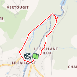
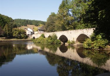
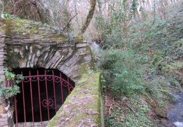
Ruta Senderismo de 3 km a descubrir en Nueva Aquitania, Corrèze, Allassac. Esta ruta ha sido propuesta por houbart.
Descripción
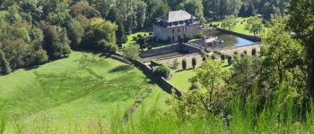
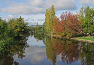
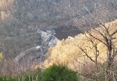
A voir : le magnifique pont médiéval du 16ème siècle "à becs" sur la Vézère avec six arches ogivales, puis la chapelle et ses vitraux signés Chagall et le château qu'on aperçoit depuis la route.
Localización
País:
France
Región :
Nueva Aquitania
Departamento/provincia :
Corrèze
Municipio :
Allassac
Localidad:
Unknown
Salida:(Dec)
Salida:(UTM)
379107 ; 5014733 (31T) N.
Comentarios
Excursiones cerca
![Senderismo Senderismo](https://static1.geolcdn.com/sitytour/trail-icons/101.png)
Garavet
Senderismo
Medio
(2)
Allassac,
Nueva Aquitania,
Corrèze,
France
![](/images/other/stat-length.png)
6,4 km | 8,6 km-effort
1h 38min
![](https://static1.geolcdn.com/siteimages/upload/files/16400158638029165_repeat_loop_refresh_sync_direction_icon.png)
Sí
![Excursión Senderismo Allassac - w-frankrijk-gorges-du-saillant - Photo](https://media.geolcdn.com/t/375/260/ext.jpg?maxdim=2&url=https%3A%2F%2Fstatic1.geolcdn.com%2Fsiteimages%2Fupload%2Ffiles%2F1553511878bg_sport_marche.png)
![Senderismo Senderismo](https://static1.geolcdn.com/sitytour/trail-icons/101.png)
w-frankrijk-gorges-du-saillant
Senderismo
Muy fácil
(1)
Allassac,
Nueva Aquitania,
Corrèze,
France
![](/images/other/stat-length.png)
7,1 km | 11,1 km-effort
Desconocido
![](https://static1.geolcdn.com/siteimages/upload/files/16400158638029165_repeat_loop_refresh_sync_direction_icon.png)
No
![Excursión Ruta Voutezac - 20201226 Saillant 20.5K - Photo](https://media.geolcdn.com/t/375/260/aafc407f-9bee-4f49-b687-53727b6a5044.jpg&format=jpg&maxdim=2)
![Ruta Ruta](https://static1.geolcdn.com/sitytour/trail-icons/104.png)
20201226 Saillant 20.5K
Ruta
Medio
Voutezac,
Nueva Aquitania,
Corrèze,
France
![](/images/other/stat-length.png)
21 km | 31 km-effort
3h 22min
![](https://static1.geolcdn.com/siteimages/upload/files/16400158638029165_repeat_loop_refresh_sync_direction_icon.png)
Sí
![Senderismo Senderismo](https://static1.geolcdn.com/sitytour/trail-icons/101.png)
Estivaux_Le Saillant-Gorges de la Vézère
Senderismo
Difícil
Estivaux,
Nueva Aquitania,
Corrèze,
France
![](/images/other/stat-length.png)
20 km | 30 km-effort
6h 0min
![](https://static1.geolcdn.com/siteimages/upload/files/16400158638029165_repeat_loop_refresh_sync_direction_icon.png)
Sí
![Excursión Senderismo Voutezac - Le Saillant - Vallée de la Vézère - Photo](https://media.geolcdn.com/t/375/260/ext.jpg?maxdim=2&url=https%3A%2F%2Fstatic1.geolcdn.com%2Fsiteimages%2Fupload%2Ffiles%2F1553511878bg_sport_marche.png)
![Senderismo Senderismo](https://static1.geolcdn.com/sitytour/trail-icons/101.png)
Le Saillant - Vallée de la Vézère
Senderismo
Muy fácil
(1)
Voutezac,
Nueva Aquitania,
Corrèze,
France
![](/images/other/stat-length.png)
9,3 km | 14 km-effort
3h 3min
![](https://static1.geolcdn.com/siteimages/upload/files/16400158638029165_repeat_loop_refresh_sync_direction_icon.png)
Sí
![Excursión Senderismo Voutezac - Ayen-160623 - Ceyrat-FontaineCrozes - Photo](https://media.geolcdn.com/t/375/260/ext.jpg?maxdim=2&url=https%3A%2F%2Fservices.sitytrail.com%2FGeolivesWS%2FDownloadMedia.ashx%3FTrailID%3D588114%26Media%3Dfix__20160623115501.jpg)
![Senderismo Senderismo](https://static1.geolcdn.com/sitytour/trail-icons/101.png)
Ayen-160623 - Ceyrat-FontaineCrozes
Senderismo
Medio
Voutezac,
Nueva Aquitania,
Corrèze,
France
![](/images/other/stat-length.png)
7,5 km | 10,7 km-effort
2h 35min
![](https://static1.geolcdn.com/siteimages/upload/files/16400158638029165_repeat_loop_refresh_sync_direction_icon.png)
Sí
![Excursión Senderismo Allassac - Allassac-Plateau des gouttes - Photo](https://media.geolcdn.com/t/375/260/ext.jpg?maxdim=2&url=https%3A%2F%2Fservices.sitytrail.com%2FGeolivesWS%2FDownloadMedia.ashx%3FTrailID%3D365978%26Media%3D3826f456-000f-47fa-b97c-4e2395cb7ac2.JPG)
![Senderismo Senderismo](https://static1.geolcdn.com/sitytour/trail-icons/101.png)
Allassac-Plateau des gouttes
Senderismo
Medio
Allassac,
Nueva Aquitania,
Corrèze,
France
![](/images/other/stat-length.png)
7,8 km | 11,1 km-effort
2h 31min
![](https://static1.geolcdn.com/siteimages/upload/files/16400158638029165_repeat_loop_refresh_sync_direction_icon.png)
Sí
![Excursión Senderismo Voutezac - Les coteaux de Vertougit - Voutezac - Photo](https://media.geolcdn.com/t/375/260/ext.jpg?maxdim=2&url=https%3A%2F%2Fservices.sitytrail.com%2FGeolivesWS%2FDownloadMedia.ashx%3FTrailID%3D318028%26Media%3D17491_3.jpg)
![Senderismo Senderismo](https://static1.geolcdn.com/sitytour/trail-icons/101.png)
Les coteaux de Vertougit - Voutezac
Senderismo
Medio
Voutezac,
Nueva Aquitania,
Corrèze,
France
![](/images/other/stat-length.png)
10,9 km | 15,3 km-effort
3h 30min
![](https://static1.geolcdn.com/siteimages/upload/files/16400158638029165_repeat_loop_refresh_sync_direction_icon.png)
Sí
![Excursión Senderismo Voutezac - La fontaine des Crozes - Voutezac - Photo](https://media.geolcdn.com/t/375/260/ext.jpg?maxdim=2&url=https%3A%2F%2Fservices.sitytrail.com%2FGeolivesWS%2FDownloadMedia.ashx%3FTrailID%3D318027%26Media%3D17490_3.jpg)
![Senderismo Senderismo](https://static1.geolcdn.com/sitytour/trail-icons/101.png)
La fontaine des Crozes - Voutezac
Senderismo
Difícil
(1)
Voutezac,
Nueva Aquitania,
Corrèze,
France
![](/images/other/stat-length.png)
11,8 km | 16,7 km-effort
3h 0min
![](https://static1.geolcdn.com/siteimages/upload/files/16400158638029165_repeat_loop_refresh_sync_direction_icon.png)
Sí