![](/images/other/stat-length.png)
![Excursión Senderismo Gavarnie-Gèdre - Pyrénées 2017 Vignemal par le glacier d'Oussue depuis le barrage d 'Oussoue - Photo](https://media.geolcdn.com/t/1900/400/ext.pjpeg?maxdim=2&url=https%3A%2F%2Fservices.sitytrail.com%2FGeolivesWS%2FDownloadMedia.ashx%3FTrailID%3D828235%26Media%3Dfix__20170825175134.jpg)
Pyrénées 2017 Vignemal par le glacier d'Oussue depuis le barrage d 'Oussoue
PatDev
Usuario
![Longitud](/images/other/stat-length.png)
Longitud
18,3 km
![Altitud máxima](https://static1.geolcdn.com/siteimages/upload/files/1508320355ic_sort_altitude_max_24dp.png)
Altitud máxima
3197 m
![Desnivel positivo](https://static1.geolcdn.com/siteimages/upload/files/1508320355ic_sort_den_pos_24dp.png)
Desnivel positivo
1665 m
![Km-Effort](/images/other/stat-length.png)
Km-Effort
40 km
![Altitud mínima](https://static1.geolcdn.com/siteimages/upload/files/1508320355ic_sort_altitude_min_24dp.png)
Altitud mínima
1737 m
![Desnivel negativo](https://static1.geolcdn.com/siteimages/upload/files/1508320355ic_sort_den_neg_24dp.png)
Desnivel negativo
1605 m
![Boucle](https://static1.geolcdn.com/siteimages/upload/files/16400158638029165_repeat_loop_refresh_sync_direction_icon.png)
Boucle
No
Fecha de creación :
2017-12-22 00:00:00.0
Última modificación :
2017-12-22 00:00:00.0
![Senderismo](https://static1.geolcdn.com/sitytour/trail-icons/101.png)
7h46
Dificultad : Muy difícil
![Escanee este código QR para abrir la excursión en la aplicación SityTrail](https://capi.geolives.com/qq0zvz2zws4bq2lad0pu/sitytour/trails/828235/qr.png?size=200)
Aplicación GPS de excursión GRATIS
A propósito
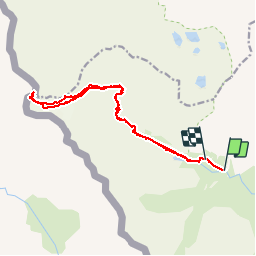
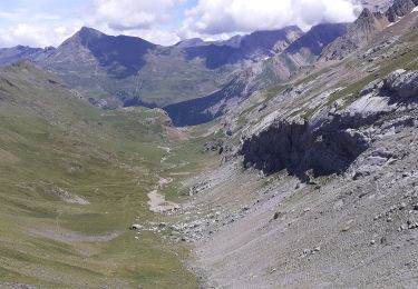
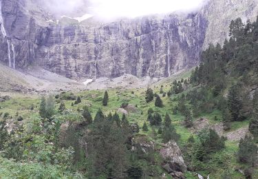
Ruta Senderismo de 18,3 km a descubrir en Occitania, Altos-Pirineos, Gavarnie-Gèdre. Esta ruta ha sido propuesta por PatDev.
Descripción
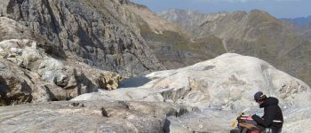
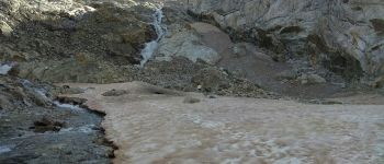
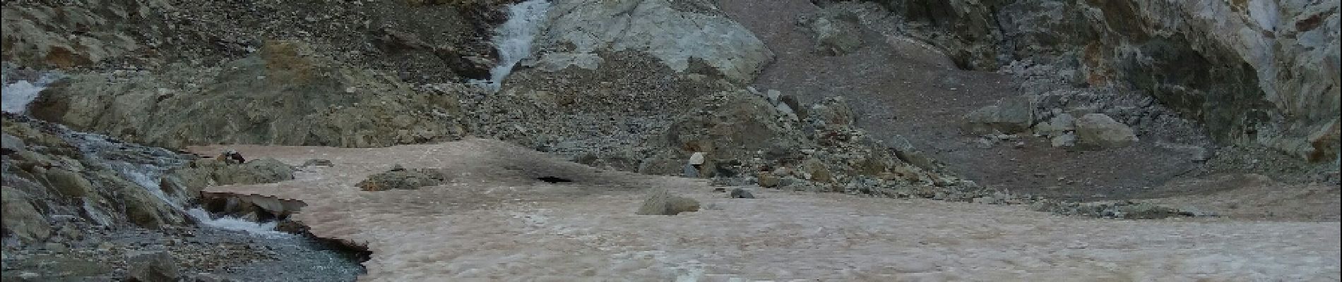
Randonnée magnifique mais très difficile. un maîtrise de la haute montagne est nécessaire (escalade, progression sur glacier avec crampon et corde).
Localización
País:
France
Región :
Occitania
Departamento/provincia :
Altos-Pirineos
Municipio :
Gavarnie-Gèdre
Localidad:
Gavarnie
Salida:(Dec)
Salida:(UTM)
738809 ; 4737678 (30T) N.
Comentarios
Excursiones cerca
![Excursión Senderismo Torla-Ordesa - Soum Blanc des Espécières-Col des Tentes - Photo](https://media.geolcdn.com/t/375/260/ext.jpg?maxdim=2&url=https%3A%2F%2Fservices.sitytrail.com%2FGeolivesWS%2FDownloadMedia.ashx%3FTrailID%3D218642%26Media%3Dfix__20130902152651.jpg)
![Senderismo Senderismo](https://static1.geolcdn.com/sitytour/trail-icons/101.png)
Soum Blanc des Espécières-Col des Tentes
Senderismo
Difícil
(7)
Torla-Ordesa,
Aragón,
Huesca,
Spain
![](/images/other/stat-length.png)
4 km | 5,7 km-effort
1h 42min
![](https://static1.geolcdn.com/siteimages/upload/files/16400158638029165_repeat_loop_refresh_sync_direction_icon.png)
No
![Excursión Senderismo Gavarnie-Gèdre - Lac de la Bernatoire - Photo](https://media.geolcdn.com/t/375/260/ext.jpg?maxdim=2&url=https%3A%2F%2Fstatic1.geolcdn.com%2Fsiteimages%2Fupload%2Ffiles%2F1553511878bg_sport_marche.png)
![Senderismo Senderismo](https://static1.geolcdn.com/sitytour/trail-icons/101.png)
Lac de la Bernatoire
Senderismo
Medio
(8)
Gavarnie-Gèdre,
Occitania,
Altos-Pirineos,
France
![](/images/other/stat-length.png)
12,7 km | 22 km-effort
4h 36min
![](https://static1.geolcdn.com/siteimages/upload/files/16400158638029165_repeat_loop_refresh_sync_direction_icon.png)
Sí
![Excursión Senderismo Gavarnie-Gèdre - Breche de Rolland - Photo](https://media.geolcdn.com/t/375/260/ext.jpg?maxdim=2&url=https%3A%2F%2Fservices.sitytrail.com%2FGeolivesWS%2FDownloadMedia.ashx%3FTrailID%3D334692%26Media%3Dfix__20140811120248.jpg)
![Senderismo Senderismo](https://static1.geolcdn.com/sitytour/trail-icons/101.png)
Breche de Rolland
Senderismo
Fácil
(3)
Gavarnie-Gèdre,
Occitania,
Altos-Pirineos,
France
![](/images/other/stat-length.png)
12,1 km | 22 km-effort
4h 34min
![](https://static1.geolcdn.com/siteimages/upload/files/16400158638029165_repeat_loop_refresh_sync_direction_icon.png)
Sí
![Excursión Senderismo Gavarnie-Gèdre - Faja de las Flores - Photo](https://media.geolcdn.com/t/375/260/ext.jpg?maxdim=2&url=https%3A%2F%2Fservices.sitytrail.com%2FGeolivesWS%2FDownloadMedia.ashx%3FTrailID%3D102724%26Media%3D3837_6.jpg)
![Senderismo Senderismo](https://static1.geolcdn.com/sitytour/trail-icons/101.png)
Faja de las Flores
Senderismo
Muy difícil
(1)
Gavarnie-Gèdre,
Occitania,
Altos-Pirineos,
France
![](/images/other/stat-length.png)
22 km | 45 km-effort
13h 0min
![](https://static1.geolcdn.com/siteimages/upload/files/16400158638029165_repeat_loop_refresh_sync_direction_icon.png)
Sí
![Excursión Senderismo Gavarnie-Gèdre - Le Soum Blanc des Especières 2685m depuis le col de Tentes - Photo](https://media.geolcdn.com/t/375/260/ext.jpg?maxdim=2&url=https%3A%2F%2Fservices.sitytrail.com%2FGeolivesWS%2FDownloadMedia.ashx%3FTrailID%3D109867%26Media%3D4854_1.jpg)
![Senderismo Senderismo](https://static1.geolcdn.com/sitytour/trail-icons/101.png)
Le Soum Blanc des Especières 2685m depuis le col de Tentes
Senderismo
Difícil
(2)
Gavarnie-Gèdre,
Occitania,
Altos-Pirineos,
France
![](/images/other/stat-length.png)
5,6 km | 12,6 km-effort
3h 0min
![](https://static1.geolcdn.com/siteimages/upload/files/16400158638029165_repeat_loop_refresh_sync_direction_icon.png)
Sí
![Excursión Senderismo Gavarnie-Gèdre - Le Casque du Marboré 3006m depuis le col de Tentes (2208m) - Photo](https://media.geolcdn.com/t/375/260/ext.jpg?maxdim=2&url=https%3A%2F%2Fservices.sitytrail.com%2FGeolivesWS%2FDownloadMedia.ashx%3FTrailID%3D109814%26Media%3D4776_1.jpg)
![Senderismo Senderismo](https://static1.geolcdn.com/sitytour/trail-icons/101.png)
Le Casque du Marboré 3006m depuis le col de Tentes (2208m)
Senderismo
Muy difícil
(1)
Gavarnie-Gèdre,
Occitania,
Altos-Pirineos,
France
![](/images/other/stat-length.png)
7 km | 16,4 km-effort
7h 0min
![](https://static1.geolcdn.com/siteimages/upload/files/16400158638029165_repeat_loop_refresh_sync_direction_icon.png)
No
![Excursión Senderismo Gavarnie-Gèdre - Brèche de Roland A/R depuis le col de Tentes - Photo](https://media.geolcdn.com/t/375/260/d0dcfe85-baea-4bbf-a123-3b041fed306d.jpg&format=jpg&maxdim=2)
![Senderismo Senderismo](https://static1.geolcdn.com/sitytour/trail-icons/101.png)
Brèche de Roland A/R depuis le col de Tentes
Senderismo
Muy difícil
Gavarnie-Gèdre,
Occitania,
Altos-Pirineos,
France
![](/images/other/stat-length.png)
13,5 km | 24 km-effort
4h 38min
![](https://static1.geolcdn.com/siteimages/upload/files/16400158638029165_repeat_loop_refresh_sync_direction_icon.png)
Sí
![Excursión Senderismo Gavarnie-Gèdre - Cirque Gavarnie - Photo](https://media.geolcdn.com/t/375/260/6c6bdbe7-fe2c-4036-a187-b055cb6dc229.jpg&format=jpg&maxdim=2)
![Senderismo Senderismo](https://static1.geolcdn.com/sitytour/trail-icons/101.png)
Cirque Gavarnie
Senderismo
Muy difícil
Gavarnie-Gèdre,
Occitania,
Altos-Pirineos,
France
![](/images/other/stat-length.png)
16,8 km | 28 km-effort
5h 0min
![](https://static1.geolcdn.com/siteimages/upload/files/16400158638029165_repeat_loop_refresh_sync_direction_icon.png)
Sí
![Excursión Senderismo Gavarnie-Gèdre - pic de Lary thmie fait - Photo](https://media.geolcdn.com/t/375/260/f11474bf-48b7-476e-be2b-f85ef1a9b455.jpg&format=jpg&maxdim=2)
![Senderismo Senderismo](https://static1.geolcdn.com/sitytour/trail-icons/101.png)
pic de Lary thmie fait
Senderismo
Medio
Gavarnie-Gèdre,
Occitania,
Altos-Pirineos,
France
![](/images/other/stat-length.png)
7,9 km | 16,6 km-effort
6h 42min
![](https://static1.geolcdn.com/siteimages/upload/files/16400158638029165_repeat_loop_refresh_sync_direction_icon.png)
Sí