![](/images/other/stat-length.png)
![Excursión Senderismo Lus-la-Croix-Haute - PARKING SABOYER - LAC DU LAUZON-01-08-2017 - Photo](https://media.geolcdn.com/t/1900/400/ext.pjpeg?maxdim=2&url=https%3A%2F%2Fservices.sitytrail.com%2FGeolivesWS%2FDownloadMedia.ashx%3FTrailID%3D822375%26Media%3D20170801115004.jpg)
PARKING SABOYER - LAC DU LAUZON-01-08-2017
RD78-38
Usuario
![Longitud](/images/other/stat-length.png)
![Altitud máxima](https://static1.geolcdn.com/siteimages/upload/files/1508320355ic_sort_altitude_max_24dp.png)
![Desnivel positivo](https://static1.geolcdn.com/siteimages/upload/files/1508320355ic_sort_den_pos_24dp.png)
![Km-Effort](/images/other/stat-length.png)
![Altitud mínima](https://static1.geolcdn.com/siteimages/upload/files/1508320355ic_sort_altitude_min_24dp.png)
![Desnivel negativo](https://static1.geolcdn.com/siteimages/upload/files/1508320355ic_sort_den_neg_24dp.png)
![Boucle](https://static1.geolcdn.com/siteimages/upload/files/16400158638029165_repeat_loop_refresh_sync_direction_icon.png)
![Senderismo](https://static1.geolcdn.com/sitytour/trail-icons/101.png)
7h06
Dificultad : Difícil
![Escanee este código QR para abrir la excursión en la aplicación SityTrail](https://capi.geolives.com/qq0zvz2zws4bq2lad0pu/sitytour/trails/822375/qr.png?size=200)
Aplicación GPS de excursión GRATIS
A propósito
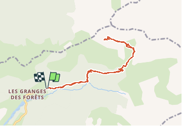
Ruta Senderismo de 10,6 km a descubrir en Auvergne-Rhône-Alpes, Drôme, Lus-la-Croix-Haute. Esta ruta ha sido propuesta por RD78-38.
Descripción
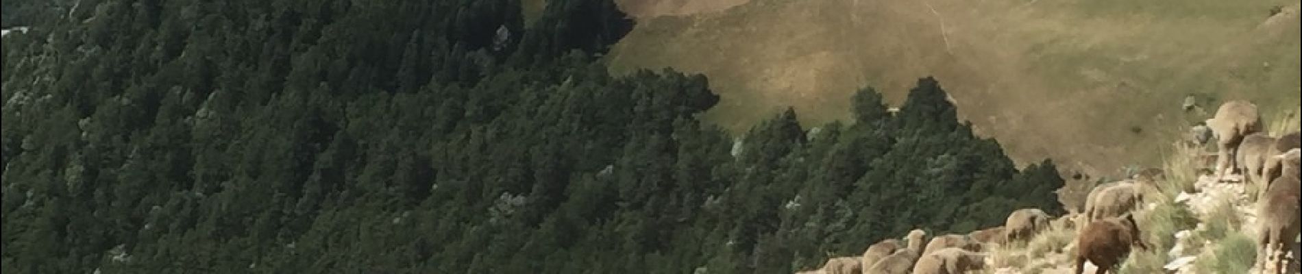
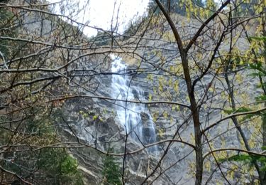
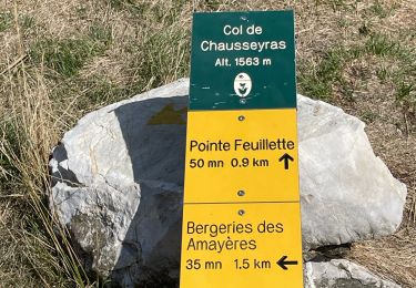
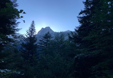
Très beau circuit avec des vues superbes (cf.Photos) Dommage que nous n'ayons pu faire la boucle prévue passant après le lac du LAUZON par le col de La Croix à cause d'un Berger qui nous a interdit de passer avec force PATOUX comme dissuasion !! C'était la première fois que nous rencontrions un tel comportement de la part d'un Berger. Nous avons dû redescendre par le même chemin. Si cela vous arrivais : attention à la descente dans les pierres !
Localización
Comentarios
Excursiones cerca
![Excursión Senderismo Lus-la-Croix-Haute - Tête de longue plate - Photo](https://media.geolcdn.com/t/375/260/0a20c58f-3b20-47ed-aad5-45f7c05509bb.jpg&format=jpg&maxdim=2)
![Senderismo Senderismo](https://static1.geolcdn.com/sitytour/trail-icons/101.png)
Senderismo
![](/images/other/stat-length.png)
![](https://static1.geolcdn.com/siteimages/upload/files/16400158638029165_repeat_loop_refresh_sync_direction_icon.png)
![Excursión Senderismo Lus-la-Croix-Haute - R41 le lac de Lauzon - Photo](https://media.geolcdn.com/t/375/260/ext.jpg?maxdim=2&url=https%3A%2F%2Fservices.sitytrail.com%2FGeolivesWS%2FDownloadMedia.ashx%3FTrailID%3D890899%26Media%3Df5ddbda0-05f9-4668-87b6-f4718cf6a3db.jpg)
![Senderismo Senderismo](https://static1.geolcdn.com/sitytour/trail-icons/101.png)
Senderismo
![](/images/other/stat-length.png)
![](https://static1.geolcdn.com/siteimages/upload/files/16400158638029165_repeat_loop_refresh_sync_direction_icon.png)
![Excursión Senderismo Lus-la-Croix-Haute - R38 Col des Aiguilles depuis Lus - Photo](https://media.geolcdn.com/t/375/260/ext.jpg?maxdim=2&url=https%3A%2F%2Fservices.sitytrail.com%2FGeolivesWS%2FDownloadMedia.ashx%3FTrailID%3D890897%26Media%3D48008b69-5aeb-41cb-8dd0-25fe44b6160d.jpg)
![Senderismo Senderismo](https://static1.geolcdn.com/sitytour/trail-icons/101.png)
Senderismo
![](/images/other/stat-length.png)
![](https://static1.geolcdn.com/siteimages/upload/files/16400158638029165_repeat_loop_refresh_sync_direction_icon.png)
![Excursión Senderismo Lus-la-Croix-Haute - R37 Col de la Croix - Photo](https://media.geolcdn.com/t/375/260/ext.jpg?maxdim=2&url=https%3A%2F%2Fservices.sitytrail.com%2FGeolivesWS%2FDownloadMedia.ashx%3FTrailID%3D890896%26Media%3D15be88b3-d922-4917-ae78-ab5d93ffe684.jpg)
![Senderismo Senderismo](https://static1.geolcdn.com/sitytour/trail-icons/101.png)
Senderismo
![](/images/other/stat-length.png)
![](https://static1.geolcdn.com/siteimages/upload/files/16400158638029165_repeat_loop_refresh_sync_direction_icon.png)
![Excursión Senderismo Tréminis - Boucle et sommet de l'Aup - Photo](https://media.geolcdn.com/t/375/260/b4bb8fed-3a0e-46fc-b5a1-1acfca2c36af.jpg&format=jpg&maxdim=2)
![Senderismo Senderismo](https://static1.geolcdn.com/sitytour/trail-icons/101.png)
Senderismo
![](/images/other/stat-length.png)
![](https://static1.geolcdn.com/siteimages/upload/files/16400158638029165_repeat_loop_refresh_sync_direction_icon.png)
![Excursión Senderismo Le Dévoluy - cabane col des Aiguilles La Jarjatte - Photo](https://media.geolcdn.com/t/375/260/e54a3991-ac4e-4a14-a7c3-660730704058.jpg&format=jpg&maxdim=2)
![Senderismo Senderismo](https://static1.geolcdn.com/sitytour/trail-icons/101.png)
Senderismo
![](/images/other/stat-length.png)
![](https://static1.geolcdn.com/siteimages/upload/files/16400158638029165_repeat_loop_refresh_sync_direction_icon.png)
![Excursión Senderismo Lus-la-Croix-Haute - MAS REBUFAT - POINTE FEUILLETTE - Photo](https://media.geolcdn.com/t/375/260/be45961d-bf40-4ff8-a175-81f334e503f2.jpg&format=jpg&maxdim=2)
![Senderismo Senderismo](https://static1.geolcdn.com/sitytour/trail-icons/101.png)
Senderismo
![](/images/other/stat-length.png)
![](https://static1.geolcdn.com/siteimages/upload/files/16400158638029165_repeat_loop_refresh_sync_direction_icon.png)
![Excursión Senderismo Lus-la-Croix-Haute - vallon jarjatte. lac lozon. col la croix - Photo](https://media.geolcdn.com/t/375/260/ab8bcb82-a4d5-45b6-9872-11aee97d90af.jpg&format=jpg&maxdim=2)
![Senderismo Senderismo](https://static1.geolcdn.com/sitytour/trail-icons/101.png)
Senderismo
![](/images/other/stat-length.png)
![](https://static1.geolcdn.com/siteimages/upload/files/16400158638029165_repeat_loop_refresh_sync_direction_icon.png)
![Excursión Senderismo Tréminis - Le col de La Croix - Photo](https://media.geolcdn.com/t/375/260/e5d94408-dab6-4b8f-bedb-4be5204f8582.jpg&format=jpg&maxdim=2)
![Senderismo Senderismo](https://static1.geolcdn.com/sitytour/trail-icons/101.png)
Senderismo
![](/images/other/stat-length.png)
![](https://static1.geolcdn.com/siteimages/upload/files/16400158638029165_repeat_loop_refresh_sync_direction_icon.png)