![](/images/other/stat-length.png)
![Excursión Senderismo Chevreuse - ALBG_Chevreuse_retracé - Photo](https://media.geolcdn.com/t/1900/400/ext.pjpeg?maxdim=2&url=https%3A%2F%2Fstatic1.geolcdn.com%2Fsiteimages%2Fupload%2Ffiles%2F1553511878bg_sport_marche.png)
ALBG_Chevreuse_retracé
IreneProvost
Usuario
![Longitud](/images/other/stat-length.png)
Longitud
11,8 km
![Altitud máxima](https://static1.geolcdn.com/siteimages/upload/files/1508320355ic_sort_altitude_max_24dp.png)
Altitud máxima
178 m
![Desnivel positivo](https://static1.geolcdn.com/siteimages/upload/files/1508320355ic_sort_den_pos_24dp.png)
Desnivel positivo
301 m
![Km-Effort](/images/other/stat-length.png)
Km-Effort
15,8 km
![Altitud mínima](https://static1.geolcdn.com/siteimages/upload/files/1508320355ic_sort_altitude_min_24dp.png)
Altitud mínima
78 m
![Desnivel negativo](https://static1.geolcdn.com/siteimages/upload/files/1508320355ic_sort_den_neg_24dp.png)
Desnivel negativo
301 m
![Boucle](https://static1.geolcdn.com/siteimages/upload/files/16400158638029165_repeat_loop_refresh_sync_direction_icon.png)
Boucle
Sí
Fecha de creación :
2018-04-16 21:43:32.136
Última modificación :
2018-04-16 21:43:32.136
![Senderismo](https://static1.geolcdn.com/sitytour/trail-icons/101.png)
2h59
Dificultad : Medio
![Escanee este código QR para abrir la excursión en la aplicación SityTrail](https://capi.geolives.com/qq0zvz2zws4bq2lad0pu/sitytour/trails/817786/qr.png?size=200)
Aplicación GPS de excursión GRATIS
A propósito
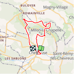
Ruta Senderismo de 11,8 km a descubrir en Isla de Francia, Yvelines, Chevreuse. Esta ruta ha sido propuesta por IreneProvost.
Descripción
Chevreuse, promenade des petits ponts, Chateau de la Madeleine, Milon-la-forêt, vers Saint-Lambert et retour par chemin Jean Racine
Localización
País:
France
Región :
Isla de Francia
Departamento/provincia :
Yvelines
Municipio :
Chevreuse
Localidad:
Unknown
Salida:(Dec)
Salida:(UTM)
429341 ; 5395239 (31U) N.
Comentarios
Excursiones cerca
![Excursión Senderismo Dampierre-en-Yvelines - _La Genèse - Photo](https://media.geolcdn.com/t/375/260/ext.jpg?maxdim=2&url=https%3A%2F%2Fservices.sitytrail.com%2FGeolivesWS%2FDownloadMedia.ashx%3FTrailID%3D746353%26Media%3D852eb799-755d-4473-ad2a-667c4a68a14c.jpg)
![Senderismo Senderismo](https://static1.geolcdn.com/sitytour/trail-icons/101.png)
_La Genèse
Senderismo
Fácil
(12)
Dampierre-en-Yvelines,
Isla de Francia,
Yvelines,
France
![](/images/other/stat-length.png)
5,7 km | 7,1 km-effort
1h 30min
![](https://static1.geolcdn.com/siteimages/upload/files/16400158638029165_repeat_loop_refresh_sync_direction_icon.png)
Sí
![Excursión Senderismo Dampierre-en-Yvelines - _Villages par mont et par vaux - Photo](https://media.geolcdn.com/t/375/260/ext.jpg?maxdim=2&url=https%3A%2F%2Fservices.sitytrail.com%2FGeolivesWS%2FDownloadMedia.ashx%3FTrailID%3D172084%26Media%3D1ba0ac7a-e5bc-4661-87da-e3aa68337b06.jpg)
![Senderismo Senderismo](https://static1.geolcdn.com/sitytour/trail-icons/101.png)
_Villages par mont et par vaux
Senderismo
Fácil
(9)
Dampierre-en-Yvelines,
Isla de Francia,
Yvelines,
France
![](/images/other/stat-length.png)
5,3 km | 7 km-effort
1h 26min
![](https://static1.geolcdn.com/siteimages/upload/files/16400158638029165_repeat_loop_refresh_sync_direction_icon.png)
Sí
![Excursión Senderismo Cernay-la-Ville - _Senlisse dans un écrin de verdure - Photo](https://media.geolcdn.com/t/375/260/ext.jpg?maxdim=2&url=https%3A%2F%2Fservices.sitytrail.com%2FGeolivesWS%2FDownloadMedia.ashx%3FTrailID%3D172082%26Media%3D58eba867-baea-4143-80e9-e47f03036c03.jpg)
![Senderismo Senderismo](https://static1.geolcdn.com/sitytour/trail-icons/101.png)
_Senlisse dans un écrin de verdure
Senderismo
Fácil
(12)
Cernay-la-Ville,
Isla de Francia,
Yvelines,
France
![](/images/other/stat-length.png)
4,5 km | 5,7 km-effort
1h 30min
![](https://static1.geolcdn.com/siteimages/upload/files/16400158638029165_repeat_loop_refresh_sync_direction_icon.png)
Sí
![Excursión Senderismo Saint-Forget - _Saint-Forget, fief de Cyrano de Bergerac - Photo](https://media.geolcdn.com/t/375/260/ext.jpg?maxdim=2&url=https%3A%2F%2Fservices.sitytrail.com%2FGeolivesWS%2FDownloadMedia.ashx%3FTrailID%3D172086%26Media%3D7b590dd2-7d00-4099-a55f-664d59f11356.jpg)
![Senderismo Senderismo](https://static1.geolcdn.com/sitytour/trail-icons/101.png)
_Saint-Forget, fief de Cyrano de Bergerac
Senderismo
Medio
(12)
Saint-Forget,
Isla de Francia,
Yvelines,
France
![](/images/other/stat-length.png)
8,5 km | 10,9 km-effort
2h 15min
![](https://static1.geolcdn.com/siteimages/upload/files/16400158638029165_repeat_loop_refresh_sync_direction_icon.png)
Sí
![Excursión Senderismo Saint-Rémy-lès-Chevreuse - _Entre vallées et châteaux - Photo](https://media.geolcdn.com/t/375/260/ext.jpg?maxdim=2&url=https%3A%2F%2Fservices.sitytrail.com%2FGeolivesWS%2FDownloadMedia.ashx%3FTrailID%3D775643%26Media%3Dde7a4f97-3e1e-4613-9986-4282e306d83b.JPG)
![Senderismo Senderismo](https://static1.geolcdn.com/sitytour/trail-icons/101.png)
_Entre vallées et châteaux
Senderismo
Medio
(13)
Saint-Rémy-lès-Chevreuse,
Isla de Francia,
Yvelines,
France
![](/images/other/stat-length.png)
7,8 km | 9,6 km-effort
2h 0min
![](https://static1.geolcdn.com/siteimages/upload/files/16400158638029165_repeat_loop_refresh_sync_direction_icon.png)
Sí
![Excursión Senderismo Chevreuse - _La balade de tous les plaisirs - Photo](https://media.geolcdn.com/t/375/260/ext.jpg?maxdim=2&url=https%3A%2F%2Fservices.sitytrail.com%2FGeolivesWS%2FDownloadMedia.ashx%3FTrailID%3D754966%26Media%3D761e5f27-0704-4761-a8b3-7fd3e291dd40.jpg)
![Senderismo Senderismo](https://static1.geolcdn.com/sitytour/trail-icons/101.png)
_La balade de tous les plaisirs
Senderismo
Fácil
(8)
Chevreuse,
Isla de Francia,
Yvelines,
France
![](/images/other/stat-length.png)
5,5 km | 7 km-effort
1h 30min
![](https://static1.geolcdn.com/siteimages/upload/files/16400158638029165_repeat_loop_refresh_sync_direction_icon.png)
Sí
![Excursión Senderismo Chevreuse - _Sur les pas de Racine (première partie) - Photo](https://media.geolcdn.com/t/375/260/ext.jpg?maxdim=2&url=https%3A%2F%2Fservices.sitytrail.com%2FGeolivesWS%2FDownloadMedia.ashx%3FTrailID%3D745166%26Media%3Dd5380f95-aa62-43a2-a37c-8510f53d593d.JPG)
![Senderismo Senderismo](https://static1.geolcdn.com/sitytour/trail-icons/101.png)
_Sur les pas de Racine (première partie)
Senderismo
Fácil
(7)
Chevreuse,
Isla de Francia,
Yvelines,
France
![](/images/other/stat-length.png)
10,7 km | 14,5 km-effort
2h 30min
![](https://static1.geolcdn.com/siteimages/upload/files/16400158638029165_repeat_loop_refresh_sync_direction_icon.png)
Sí
![Excursión Senderismo Choisel - _Si Choisel m'était conté - Photo](https://media.geolcdn.com/t/375/260/ext.jpg?maxdim=2&url=https%3A%2F%2Fservices.sitytrail.com%2FGeolivesWS%2FDownloadMedia.ashx%3FTrailID%3D172083%26Media%3De60082f0-edf4-45f4-997a-35e9c7c799de.jpg)
![Senderismo Senderismo](https://static1.geolcdn.com/sitytour/trail-icons/101.png)
_Si Choisel m'était conté
Senderismo
Fácil
(8)
Choisel,
Isla de Francia,
Yvelines,
France
![](/images/other/stat-length.png)
5,6 km | 6,6 km-effort
1h 27min
![](https://static1.geolcdn.com/siteimages/upload/files/16400158638029165_repeat_loop_refresh_sync_direction_icon.png)
Sí
![Excursión Senderismo Magny-les-Hameaux - _La Vallée de la Mérantaise - Photo](https://media.geolcdn.com/t/375/260/ext.jpg?maxdim=2&url=https%3A%2F%2Fservices.sitytrail.com%2FGeolivesWS%2FDownloadMedia.ashx%3FTrailID%3D755616%26Media%3Deae23003-4ad7-4454-b083-3d96818374a8.jpg)
![Senderismo Senderismo](https://static1.geolcdn.com/sitytour/trail-icons/101.png)
_La Vallée de la Mérantaise
Senderismo
Fácil
(5)
Magny-les-Hameaux,
Isla de Francia,
Yvelines,
France
![](/images/other/stat-length.png)
9,7 km | 11,6 km-effort
2h 30min
![](https://static1.geolcdn.com/siteimages/upload/files/16400158638029165_repeat_loop_refresh_sync_direction_icon.png)
Sí