![](/images/other/stat-length.png)
![Excursión Senderismo Tignes - Col de Rhêmes-Golette - Photo](https://media.geolcdn.com/t/1900/400/ext.pjpeg?maxdim=2&url=https%3A%2F%2Fservices.sitytrail.com%2FGeolivesWS%2FDownloadMedia.ashx%3FTrailID%3D815791%26Media%3Dfix__20170823111256.jpg)
Col de Rhêmes-Golette
amiral13
Usuario GUIDE
![Longitud](/images/other/stat-length.png)
Longitud
17,1 km
![Altitud máxima](https://static1.geolcdn.com/siteimages/upload/files/1508320355ic_sort_altitude_max_24dp.png)
Altitud máxima
3092 m
![Desnivel positivo](https://static1.geolcdn.com/siteimages/upload/files/1508320355ic_sort_den_pos_24dp.png)
Desnivel positivo
859 m
![Km-Effort](/images/other/stat-length.png)
Km-Effort
29 km
![Altitud mínima](https://static1.geolcdn.com/siteimages/upload/files/1508320355ic_sort_altitude_min_24dp.png)
Altitud mínima
2286 m
![Desnivel negativo](https://static1.geolcdn.com/siteimages/upload/files/1508320355ic_sort_den_neg_24dp.png)
Desnivel negativo
859 m
![Boucle](https://static1.geolcdn.com/siteimages/upload/files/16400158638029165_repeat_loop_refresh_sync_direction_icon.png)
Boucle
Sí
Fecha de creación :
2017-08-27 00:00:00.0
Última modificación :
2017-08-27 00:00:00.0
![Senderismo](https://static1.geolcdn.com/sitytour/trail-icons/101.png)
8h09
Dificultad : Medio
![Escanee este código QR para abrir la excursión en la aplicación SityTrail](https://capi.geolives.com/qq0zvz2zws4bq2lad0pu/sitytour/trails/815791/qr.png?size=200)
Aplicación GPS de excursión GRATIS
A propósito
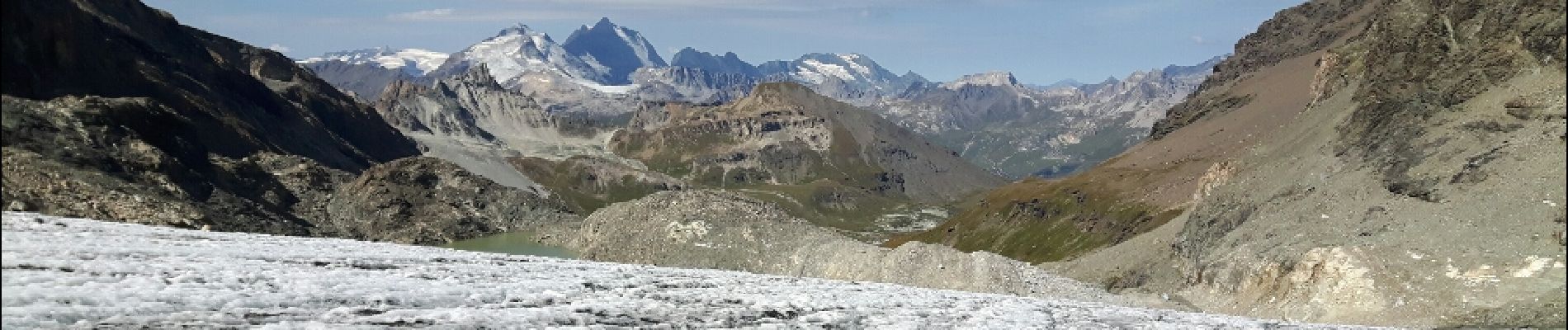
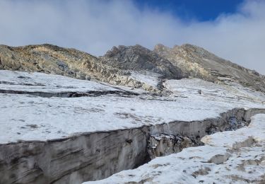
Ruta Senderismo de 17,1 km a descubrir en Auvergne-Rhône-Alpes, Saboya, Tignes. Esta ruta ha sido propuesta por amiral13.
Descripción
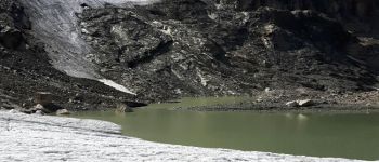
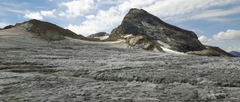
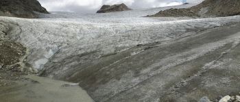
attention les 200 derniers mètres de dénivelé, s'effectue sur un glacier. prévoir crampons piolets et cordes
cette randonnée a été réalisée avec un enfant de 9 ans, le temps de parcours peut être donc être réduit.
Localización
País:
France
Región :
Auvergne-Rhône-Alpes
Departamento/provincia :
Saboya
Municipio :
Tignes
Localidad:
Unknown
Salida:(Dec)
Salida:(UTM)
341247 ; 5039010 (32T) N.
Comentarios
Excursiones cerca
![Excursión Senderismo Val-d'Isère - rocher du Charvet - Photo](https://media.geolcdn.com/t/375/260/695e5e9f-e8dc-4cf9-b576-ab38f18a42af.jpg&format=jpg&maxdim=2)
![Senderismo Senderismo](https://static1.geolcdn.com/sitytour/trail-icons/101.png)
rocher du Charvet
Senderismo
Difícil
(1)
Val-d'Isère,
Auvergne-Rhône-Alpes,
Saboya,
France
![](/images/other/stat-length.png)
12,6 km | 20 km-effort
5h 10min
![](https://static1.geolcdn.com/siteimages/upload/files/16400158638029165_repeat_loop_refresh_sync_direction_icon.png)
No
![Excursión Senderismo Tignes - la pointe de Picheru - Photo](https://media.geolcdn.com/t/375/260/ext.jpg?maxdim=2&url=https%3A%2F%2Fservices.sitytrail.com%2FGeolivesWS%2FDownloadMedia.ashx%3FTrailID%3D813856%26Media%3Dfix__20170820100255.jpg)
![Senderismo Senderismo](https://static1.geolcdn.com/sitytour/trail-icons/101.png)
la pointe de Picheru
Senderismo
Medio
(1)
Tignes,
Auvergne-Rhône-Alpes,
Saboya,
France
![](/images/other/stat-length.png)
13,8 km | 23 km-effort
5h 36min
![](https://static1.geolcdn.com/siteimages/upload/files/16400158638029165_repeat_loop_refresh_sync_direction_icon.png)
Sí
![Excursión Senderismo Tignes - lacs du saut et de la sassiere - Photo](https://media.geolcdn.com/t/375/260/ext.jpg?maxdim=2&url=https%3A%2F%2Fservices.sitytrail.com%2FGeolivesWS%2FDownloadMedia.ashx%3FTrailID%3D336967%26Media%3D637041f5-cff1-4406-a972-10b75ef104dd.JPG)
![Senderismo Senderismo](https://static1.geolcdn.com/sitytour/trail-icons/101.png)
lacs du saut et de la sassiere
Senderismo
Muy fácil
(3)
Tignes,
Auvergne-Rhône-Alpes,
Saboya,
France
![](/images/other/stat-length.png)
9 km | 12,6 km-effort
3h 56min
![](https://static1.geolcdn.com/siteimages/upload/files/16400158638029165_repeat_loop_refresh_sync_direction_icon.png)
Sí
![Excursión Senderismo Tignes - Tignes 1800 lac de la Sassièrre aller-retour - Photo](https://media.geolcdn.com/t/375/260/ae37ca96-9517-4fd4-82f6-2f8c10f3622c.jpg&format=jpg&maxdim=2)
![Senderismo Senderismo](https://static1.geolcdn.com/sitytour/trail-icons/101.png)
Tignes 1800 lac de la Sassièrre aller-retour
Senderismo
Medio
(1)
Tignes,
Auvergne-Rhône-Alpes,
Saboya,
France
![](/images/other/stat-length.png)
28 km | 47 km-effort
1h 0min
![](https://static1.geolcdn.com/siteimages/upload/files/16400158638029165_repeat_loop_refresh_sync_direction_icon.png)
Sí
![Excursión Senderismo Tignes - boucle Tignes le lac - la daille - Photo](https://media.geolcdn.com/t/375/260/ext.jpg?maxdim=2&url=https%3A%2F%2Fservices.sitytrail.com%2FGeolivesWS%2FDownloadMedia.ashx%3FTrailID%3D132978%26Media%3D20120609144529.jpg)
![Senderismo Senderismo](https://static1.geolcdn.com/sitytour/trail-icons/101.png)
boucle Tignes le lac - la daille
Senderismo
Fácil
(1)
Tignes,
Auvergne-Rhône-Alpes,
Saboya,
France
![](/images/other/stat-length.png)
14 km | 23 km-effort
2h 56min
![](https://static1.geolcdn.com/siteimages/upload/files/16400158638029165_repeat_loop_refresh_sync_direction_icon.png)
Sí
![Excursión Senderismo Val-d'Isère - Les cascades des salins au départ de val d’Isère - Photo](https://media.geolcdn.com/t/375/260/c3b76218-f72c-4eeb-8155-41f32eab8f13.jpg&format=jpg&maxdim=2)
![Senderismo Senderismo](https://static1.geolcdn.com/sitytour/trail-icons/101.png)
Les cascades des salins au départ de val d’Isère
Senderismo
Medio
(1)
Val-d'Isère,
Auvergne-Rhône-Alpes,
Saboya,
France
![](/images/other/stat-length.png)
9,5 km | 15,2 km-effort
3h 40min
![](https://static1.geolcdn.com/siteimages/upload/files/16400158638029165_repeat_loop_refresh_sync_direction_icon.png)
Sí
![Excursión Senderismo Tignes - Refuge de la Martin - Photo](https://media.geolcdn.com/t/375/260/ext.jpg?maxdim=2&url=https%3A%2F%2Fservices.sitytrail.com%2FGeolivesWS%2FDownloadMedia.ashx%3FTrailID%3D853550%26Media%3Dfix__20171025152818.jpg)
![Senderismo Senderismo](https://static1.geolcdn.com/sitytour/trail-icons/101.png)
Refuge de la Martin
Senderismo
Medio
(1)
Tignes,
Auvergne-Rhône-Alpes,
Saboya,
France
![](/images/other/stat-length.png)
13,3 km | 26 km-effort
6h 4min
![](https://static1.geolcdn.com/siteimages/upload/files/16400158638029165_repeat_loop_refresh_sync_direction_icon.png)
Sí
![Excursión Senderismo Tignes - approche glacière de la cime de la Golette - Photo](https://media.geolcdn.com/t/375/260/72e50cb0-5647-449b-b1a2-a84fe5e68f8a.jpg&format=jpg&maxdim=2)
![Senderismo Senderismo](https://static1.geolcdn.com/sitytour/trail-icons/101.png)
approche glacière de la cime de la Golette
Senderismo
Muy difícil
Tignes,
Auvergne-Rhône-Alpes,
Saboya,
France
![](/images/other/stat-length.png)
18,5 km | 32 km-effort
8h 29min
![](https://static1.geolcdn.com/siteimages/upload/files/16400158638029165_repeat_loop_refresh_sync_direction_icon.png)
Sí
![Excursión Senderismo Val-d'Isère - Lac, col et pointe de la Bailletaz - Photo](https://media.geolcdn.com/t/375/260/9d40bc9e-390f-4a5e-a6f3-053ea09f211b.jpg&format=jpg&maxdim=2)
![Senderismo Senderismo](https://static1.geolcdn.com/sitytour/trail-icons/101.png)
Lac, col et pointe de la Bailletaz
Senderismo
Difícil
Val-d'Isère,
Auvergne-Rhône-Alpes,
Saboya,
France
![](/images/other/stat-length.png)
9,6 km | 23 km-effort
4h 35min
![](https://static1.geolcdn.com/siteimages/upload/files/16400158638029165_repeat_loop_refresh_sync_direction_icon.png)
Sí