![](/images/other/stat-length.png)
mamelle sud de Beaune
Gouze13
Usuario
![Longitud](/images/other/stat-length.png)
Longitud
4,1 km
![Altitud máxima](https://static1.geolcdn.com/siteimages/upload/files/1508320355ic_sort_altitude_max_24dp.png)
Altitud máxima
2418 m
![Desnivel positivo](https://static1.geolcdn.com/siteimages/upload/files/1508320355ic_sort_den_pos_24dp.png)
Desnivel positivo
1037 m
![Km-Effort](/images/other/stat-length.png)
Km-Effort
14,6 km
![Altitud mínima](https://static1.geolcdn.com/siteimages/upload/files/1508320355ic_sort_altitude_min_24dp.png)
Altitud mínima
1364 m
![Desnivel negativo](https://static1.geolcdn.com/siteimages/upload/files/1508320355ic_sort_den_neg_24dp.png)
Desnivel negativo
18 m
![Boucle](https://static1.geolcdn.com/siteimages/upload/files/16400158638029165_repeat_loop_refresh_sync_direction_icon.png)
Boucle
No
Fecha de creación :
2017-09-13 00:00:00.0
Última modificación :
2018-09-06 11:24:18.44
![Senderismo](https://static1.geolcdn.com/sitytour/trail-icons/101.png)
5h00
Dificultad : Muy difícil
![Escanee este código QR para abrir la excursión en la aplicación SityTrail](https://capi.geolives.com/qq0zvz2zws4bq2lad0pu/sitytour/trails/814840/qr.png?size=200)
Aplicación GPS de excursión GRATIS
A propósito
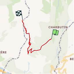
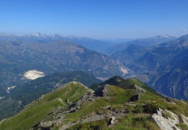
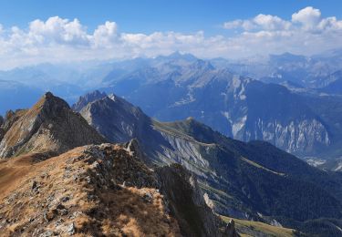
Ruta Senderismo de 4,1 km a descubrir en Auvergne-Rhône-Alpes, Saboya, Saint-Martin-de-la-Porte. Esta ruta ha sido propuesta por Gouze13.
Descripción
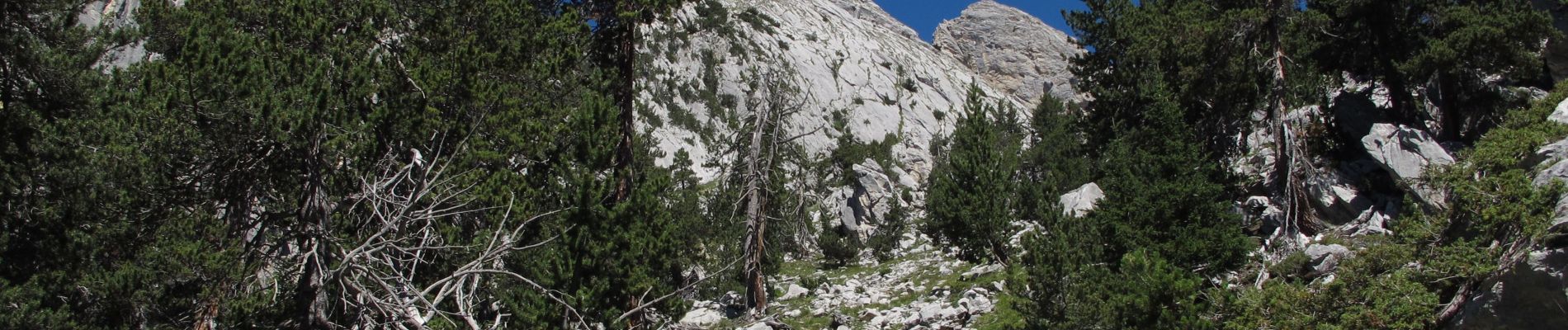
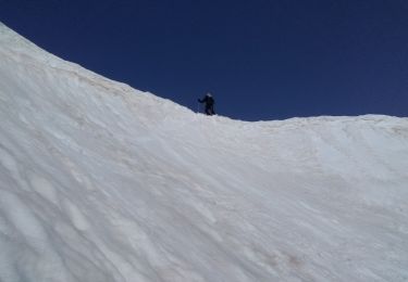
Attention: Passages trés exposés, toute chute interdite. Avoir le pied trés sur.
Localización
País:
France
Región :
Auvergne-Rhône-Alpes
Departamento/provincia :
Saboya
Municipio :
Saint-Martin-de-la-Porte
Localidad:
Unknown
Salida:(Dec)
Salida:(UTM)
300586 ; 5014804 (32T) N.
Comentarios
Excursiones cerca
![Excursión Senderismo Saint-Martin-de-la-Porte - Pointe de la Masse-2023-09-24 - Photo](https://media.geolcdn.com/t/375/260/4b3cf49d-3183-4ff4-940d-b53cd4b7fc6c.jpg&format=jpg&maxdim=2)
![Senderismo Senderismo](https://static1.geolcdn.com/sitytour/trail-icons/101.png)
Pointe de la Masse-2023-09-24
Senderismo
Medio
(1)
Saint-Martin-de-la-Porte,
Auvergne-Rhône-Alpes,
Saboya,
France
![](/images/other/stat-length.png)
14,4 km | 27 km-effort
6h 2min
![](https://static1.geolcdn.com/siteimages/upload/files/16400158638029165_repeat_loop_refresh_sync_direction_icon.png)
Sí
![Excursión Esquí de fondo Saint-Michel-de-Maurienne - Col de la vallée étroite - Photo](https://media.geolcdn.com/t/375/260/aa2d310a-3782-4038-86c9-eb570518a405.jpg&format=jpg&maxdim=2)
![Esquí de fondo Esquí de fondo](https://static1.geolcdn.com/sitytour/trail-icons/503.png)
Col de la vallée étroite
Esquí de fondo
Fácil
Saint-Michel-de-Maurienne,
Auvergne-Rhône-Alpes,
Saboya,
France
![](/images/other/stat-length.png)
12,6 km | 30 km-effort
4h 7min
![](https://static1.geolcdn.com/siteimages/upload/files/16400158638029165_repeat_loop_refresh_sync_direction_icon.png)
Sí
![Excursión Senderismo Saint-Julien-Mont-Denis - st Julien - la clochette - Tourmentier - Photo](https://media.geolcdn.com/t/375/260/256dfaaf-3559-4441-9fd1-5dc5f27e6fad.jpg&format=jpg&maxdim=2)
![Senderismo Senderismo](https://static1.geolcdn.com/sitytour/trail-icons/101.png)
st Julien - la clochette - Tourmentier
Senderismo
Difícil
Saint-Julien-Mont-Denis,
Auvergne-Rhône-Alpes,
Saboya,
France
![](/images/other/stat-length.png)
9,7 km | 21 km-effort
4h 14min
![](https://static1.geolcdn.com/siteimages/upload/files/16400158638029165_repeat_loop_refresh_sync_direction_icon.png)
Sí
![Excursión Esquí de fondo Saint-Michel-de-Maurienne - sous le petit perron des encombres - Photo](https://media.geolcdn.com/t/375/260/0548a01d-33b1-4615-bf66-0a041c8d7b3c.jpg&format=jpg&maxdim=2)
![Esquí de fondo Esquí de fondo](https://static1.geolcdn.com/sitytour/trail-icons/503.png)
sous le petit perron des encombres
Esquí de fondo
Medio
Saint-Michel-de-Maurienne,
Auvergne-Rhône-Alpes,
Saboya,
France
![](/images/other/stat-length.png)
68 km | 181 km-effort
6h 45min
![](https://static1.geolcdn.com/siteimages/upload/files/16400158638029165_repeat_loop_refresh_sync_direction_icon.png)
No
![Senderismo Senderismo](https://static1.geolcdn.com/sitytour/trail-icons/101.png)
Casse Massion
Senderismo
Medio
(1)
Montricher-Albanne,
Auvergne-Rhône-Alpes,
Saboya,
France
![](/images/other/stat-length.png)
7,1 km | 17,7 km-effort
2h 20min
![](https://static1.geolcdn.com/siteimages/upload/files/16400158638029165_repeat_loop_refresh_sync_direction_icon.png)
Sí
![Excursión Senderismo Les Belleville - descente point de la masse - Photo](https://media.geolcdn.com/t/375/260/ext.jpg?maxdim=2&url=https%3A%2F%2Fstatic1.geolcdn.com%2Fsiteimages%2Fupload%2Ffiles%2F1553511878bg_sport_marche.png)
![Senderismo Senderismo](https://static1.geolcdn.com/sitytour/trail-icons/101.png)
descente point de la masse
Senderismo
Medio
(1)
Les Belleville,
Auvergne-Rhône-Alpes,
Saboya,
France
![](/images/other/stat-length.png)
9,3 km | 13,3 km-effort
3h 30min
![](https://static1.geolcdn.com/siteimages/upload/files/16400158638029165_repeat_loop_refresh_sync_direction_icon.png)
No
![Excursión Raquetas de nieve Montricher-Albanne - a021 - Photo](https://media.geolcdn.com/t/375/260/ext.jpg?maxdim=2&url=https%3A%2F%2Fstatic1.geolcdn.com%2Fsiteimages%2Fupload%2Ffiles%2F1524743153raquette.jpg)
![Raquetas de nieve Raquetas de nieve](https://static1.geolcdn.com/sitytour/trail-icons/504.png)
a021
Raquetas de nieve
Muy fácil
(1)
Montricher-Albanne,
Auvergne-Rhône-Alpes,
Saboya,
France
![](/images/other/stat-length.png)
5,4 km | 8,6 km-effort
1h 44min
![](https://static1.geolcdn.com/siteimages/upload/files/16400158638029165_repeat_loop_refresh_sync_direction_icon.png)
Sí
![Excursión Ruta Saint-Julien-Mont-Denis - Tour des ardoisières, Montdenis - Photo](https://media.geolcdn.com/t/375/260/ext.jpg?maxdim=2&url=https%3A%2F%2Fstatic1.geolcdn.com%2Fsiteimages%2Fupload%2Ffiles%2F1524743154running.jpg)
![Ruta Ruta](https://static1.geolcdn.com/sitytour/trail-icons/104.png)
Tour des ardoisières, Montdenis
Ruta
Difícil
(1)
Saint-Julien-Mont-Denis,
Auvergne-Rhône-Alpes,
Saboya,
France
![](/images/other/stat-length.png)
8,6 km | 18,2 km-effort
2h 30min
![](https://static1.geolcdn.com/siteimages/upload/files/16400158638029165_repeat_loop_refresh_sync_direction_icon.png)
Sí
![Excursión Senderismo Saint-Martin-de-la-Porte - Grand Perron des Encombres - Photo](https://media.geolcdn.com/t/375/260/a4fcd5cd-2492-4e56-83a0-8fbe10fa31a6.jpg&format=jpg&maxdim=2)
![Senderismo Senderismo](https://static1.geolcdn.com/sitytour/trail-icons/101.png)
Grand Perron des Encombres
Senderismo
Difícil
Saint-Martin-de-la-Porte,
Auvergne-Rhône-Alpes,
Saboya,
France
![](/images/other/stat-length.png)
9,3 km | 20 km-effort
5h 45min
![](https://static1.geolcdn.com/siteimages/upload/files/16400158638029165_repeat_loop_refresh_sync_direction_icon.png)
Sí