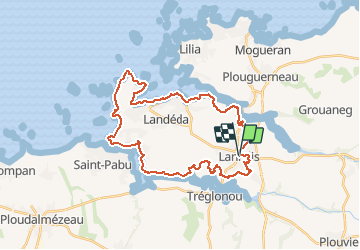
![](/images/other/stat-length.png)
![Excursión Senderismo Lannilis - Tour de la presqu’île de Sainte Marguerite - Photo](https://media.geolcdn.com/t/1900/400/ext.pjpeg?maxdim=2&url=https%3A%2F%2Fstatic1.geolcdn.com%2Fsiteimages%2Fupload%2Ffiles%2F1553511878bg_sport_marche.png)
Tour de la presqu’île de Sainte Marguerite
Balades en Finistère
Promenez-vous au bout du monde !
![Longitud](/images/other/stat-length.png)
![Altitud máxima](https://static1.geolcdn.com/siteimages/upload/files/1508320355ic_sort_altitude_max_24dp.png)
![Desnivel positivo](https://static1.geolcdn.com/siteimages/upload/files/1508320355ic_sort_den_pos_24dp.png)
![Km-Effort](/images/other/stat-length.png)
![Altitud mínima](https://static1.geolcdn.com/siteimages/upload/files/1508320355ic_sort_altitude_min_24dp.png)
![Desnivel negativo](https://static1.geolcdn.com/siteimages/upload/files/1508320355ic_sort_den_neg_24dp.png)
![Boucle](https://static1.geolcdn.com/siteimages/upload/files/16400158638029165_repeat_loop_refresh_sync_direction_icon.png)
![Senderismo](https://static1.geolcdn.com/sitytour/trail-icons/101.png)
8h03
Dificultad : Medio
![Escanee este código QR para abrir la excursión en la aplicación SityTrail](https://capi.geolives.com/qq0zvz2zws4bq2lad0pu/sitytour/trails/811583/qr.png?size=200)
Aplicación GPS de excursión GRATIS
A propósito
Ruta Senderismo de 32 km a descubrir en Bretaña, Finisterre, Lannilis. Esta ruta ha sido propuesta por Balades en Finistère.
Descripción
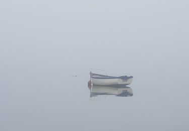
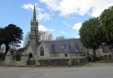
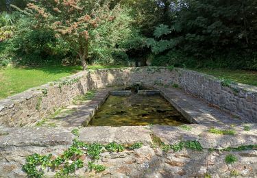
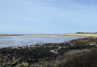
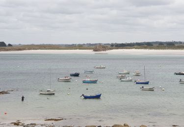
Le grand tour de la presqu'ile de Sainte Marguerite. Au départ de Lannilis, on longe la rive nord de l'aber Benoit pour retrouver la mer d'Iroise puis la rive sud de l'aber Wrac'h. Attention, à marée haute de coefficient supérieur à 80, certains passages côtiers sont impraticables.
Localización
Comentarios
Excursiones cerca
![Excursión Senderismo Plouvien - Autour de Plouvien - Photo](https://media.geolcdn.com/t/375/260/ext.jpg?maxdim=2&url=https%3A%2F%2Fservices.sitytrail.com%2FGeolivesWS%2FDownloadMedia.ashx%3FTrailID%3D109300%26Media%3D3529_1.jpg)
![Senderismo Senderismo](https://static1.geolcdn.com/sitytour/trail-icons/101.png)
Senderismo
![](/images/other/stat-length.png)
![](https://static1.geolcdn.com/siteimages/upload/files/16400158638029165_repeat_loop_refresh_sync_direction_icon.png)
![Excursión Senderismo Landéda - 06.09.24 Landéda -- Treglonou (Touzilit) - Photo](https://media.geolcdn.com/t/375/260/ec11815a-c8fb-467a-9689-1ba3e69aa97c.jpg&format=jpg&maxdim=2)
![Senderismo Senderismo](https://static1.geolcdn.com/sitytour/trail-icons/101.png)
Senderismo
![](/images/other/stat-length.png)
![](https://static1.geolcdn.com/siteimages/upload/files/16400158638029165_repeat_loop_refresh_sync_direction_icon.png)
![Excursión Senderismo Landéda - AberWrac'h - Traon Bizin - 4km - Photo](https://media.geolcdn.com/t/375/260/ext.jpg?maxdim=2&url=https%3A%2F%2Fstatic1.geolcdn.com%2Fsiteimages%2Fupload%2Ffiles%2F1553511878bg_sport_marche.png)
![Senderismo Senderismo](https://static1.geolcdn.com/sitytour/trail-icons/101.png)
Senderismo
![](/images/other/stat-length.png)
![](https://static1.geolcdn.com/siteimages/upload/files/16400158638029165_repeat_loop_refresh_sync_direction_icon.png)
![Excursión Senderismo Landéda - Aberwac’h la dune (boucle) - Photo](https://media.geolcdn.com/t/375/260/e7189307-e1c4-4d36-a21c-92827b960ec1.jpg&format=jpg&maxdim=2)
![Senderismo Senderismo](https://static1.geolcdn.com/sitytour/trail-icons/101.png)
Senderismo
![](/images/other/stat-length.png)
![](https://static1.geolcdn.com/siteimages/upload/files/16400158638029165_repeat_loop_refresh_sync_direction_icon.png)
![Excursión Senderismo Tréglonou - 07.09.23 Trouzilit -- Ploudalmézeau - Photo](https://media.geolcdn.com/t/375/260/4d914aa5-6c40-441a-82d6-52fface3f0bb.jpg&format=jpg&maxdim=2)
![Senderismo Senderismo](https://static1.geolcdn.com/sitytour/trail-icons/101.png)
Senderismo
![](/images/other/stat-length.png)
![](https://static1.geolcdn.com/siteimages/upload/files/16400158638029165_repeat_loop_refresh_sync_direction_icon.png)
![Excursión Marcha nórdica Landéda - Abers vrac Aber Benoît - Photo](https://media.geolcdn.com/t/375/260/4710018b-ab0b-4599-9439-cb1eef86434c.jpg&format=jpg&maxdim=2)
![Marcha nórdica Marcha nórdica](https://static1.geolcdn.com/sitytour/trail-icons/102.png)
Marcha nórdica
![](/images/other/stat-length.png)
![](https://static1.geolcdn.com/siteimages/upload/files/16400158638029165_repeat_loop_refresh_sync_direction_icon.png)
![Excursión Senderismo Tréglonou - Tréglonou - Portsall - Photo](https://media.geolcdn.com/t/375/260/c7d22bff-e37f-446d-a165-127937e8fd08.jpg&format=jpg&maxdim=2)
![Senderismo Senderismo](https://static1.geolcdn.com/sitytour/trail-icons/101.png)
Senderismo
![](/images/other/stat-length.png)
![](https://static1.geolcdn.com/siteimages/upload/files/16400158638029165_repeat_loop_refresh_sync_direction_icon.png)
![Excursión Senderismo Landéda - Aber Wrac'h - Photo](https://media.geolcdn.com/t/375/260/7b637bde-55c1-41b8-9681-f16bd1ae981d.jpg&format=jpg&maxdim=2)
![Senderismo Senderismo](https://static1.geolcdn.com/sitytour/trail-icons/101.png)
![Excursión A pie Plouvien - Rand'Abers 11 - Photo](https://media.geolcdn.com/t/375/260/00254f06-e1aa-4530-abb1-23bfa4f699b4.jpeg&format=jpg&maxdim=2)
![A pie A pie](https://static1.geolcdn.com/sitytour/trail-icons/100.png)