![](/images/other/stat-length.png)
![Excursión Senderismo Neuvéglise-sur-Truyère - Tour pédestre du Cantal 2017 Lavastrie - Photo](https://media.geolcdn.com/t/1900/400/ext.pjpeg?maxdim=2&url=https%3A%2F%2Fstatic1.geolcdn.com%2Fsiteimages%2Fupload%2Ffiles%2F1553511878bg_sport_marche.png)
Tour pédestre du Cantal 2017 Lavastrie
planets
Usuario
![Longitud](/images/other/stat-length.png)
![Altitud máxima](https://static1.geolcdn.com/siteimages/upload/files/1508320355ic_sort_altitude_max_24dp.png)
![Desnivel positivo](https://static1.geolcdn.com/siteimages/upload/files/1508320355ic_sort_den_pos_24dp.png)
![Km-Effort](/images/other/stat-length.png)
![Altitud mínima](https://static1.geolcdn.com/siteimages/upload/files/1508320355ic_sort_altitude_min_24dp.png)
![Desnivel negativo](https://static1.geolcdn.com/siteimages/upload/files/1508320355ic_sort_den_neg_24dp.png)
![Boucle](https://static1.geolcdn.com/siteimages/upload/files/16400158638029165_repeat_loop_refresh_sync_direction_icon.png)
![Senderismo](https://static1.geolcdn.com/sitytour/trail-icons/101.png)
4h57
Dificultad : Fácil
![Escanee este código QR para abrir la excursión en la aplicación SityTrail](https://capi.geolives.com/qq0zvz2zws4bq2lad0pu/sitytour/trails/798473/qr.png?size=200)
Aplicación GPS de excursión GRATIS
A propósito
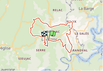
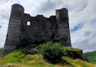
Ruta Senderismo de 17,6 km a descubrir en Auvergne-Rhône-Alpes, Cantal, Neuvéglise-sur-Truyère. Esta ruta ha sido propuesta por planets.
Descripción
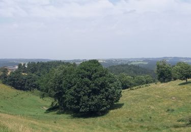
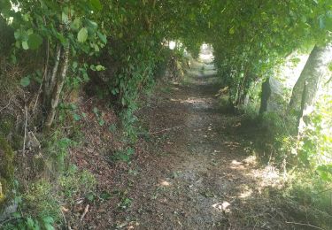
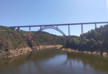
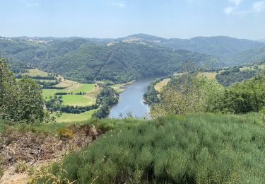
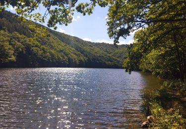
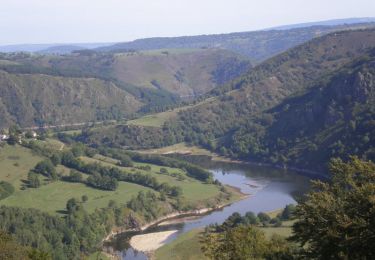
Descente du bourg jusqu'à une belle vue sur le barrage et le lac. Le vieux four de Fauges mérite un petit arrêt. Retour sur le plateau. Petite Chapelle à Fontbonne dédiée à Saint Roch. Architecture remarquable à Tarrieux. Point de vue sur le lac et la Margeride depuis le puy de Montbrun (on voie le viaduc de Garabit). Belle église et jolies maisons au bourg à Lavastrie.
Localización
Comentarios
Excursiones cerca
![Excursión Senderismo Fridefont - Magnac - Photo](https://media.geolcdn.com/t/375/260/bd259a51-4b76-408c-92e2-ca82a9517d42.jpg&format=jpg&maxdim=2)
![Senderismo Senderismo](https://static1.geolcdn.com/sitytour/trail-icons/101.png)
Senderismo
![](/images/other/stat-length.png)
![](https://static1.geolcdn.com/siteimages/upload/files/16400158638029165_repeat_loop_refresh_sync_direction_icon.png)
![Excursión Senderismo Fridefont - Les gorges de Bès - Photo](https://media.geolcdn.com/t/375/260/355a8234-906c-48fe-a1fa-b94a4304f223.jpg&format=jpg&maxdim=2)
![Senderismo Senderismo](https://static1.geolcdn.com/sitytour/trail-icons/101.png)
Senderismo
![](/images/other/stat-length.png)
![](https://static1.geolcdn.com/siteimages/upload/files/16400158638029165_repeat_loop_refresh_sync_direction_icon.png)
![Excursión Bici de carretera Fridefont - La vallée de Truyère - Photo](https://media.geolcdn.com/t/375/260/7b822ba6-e872-4da7-b587-53102ee447a8.jpg&format=jpg&maxdim=2)
![Bici de carretera Bici de carretera](https://static1.geolcdn.com/sitytour/trail-icons/201.png)
Bici de carretera
![](/images/other/stat-length.png)
![](https://static1.geolcdn.com/siteimages/upload/files/16400158638029165_repeat_loop_refresh_sync_direction_icon.png)
![Excursión Senderismo Fridefont - Magnan - Photo](https://media.geolcdn.com/t/375/260/3a9b6554-8053-4aed-ad8a-158ccb895998.jpg&format=jpg&maxdim=2)
![Senderismo Senderismo](https://static1.geolcdn.com/sitytour/trail-icons/101.png)
Senderismo
![](/images/other/stat-length.png)
![](https://static1.geolcdn.com/siteimages/upload/files/16400158638029165_repeat_loop_refresh_sync_direction_icon.png)
![Excursión Carrera Fridefont - La Mourache - Photo](https://media.geolcdn.com/t/375/260/a1a0bff6-c2ab-4782-9c75-2642aa8c3415.jpg&format=jpg&maxdim=2)
![Carrera Carrera](https://static1.geolcdn.com/sitytour/trail-icons/103.png)
Carrera
![](/images/other/stat-length.png)
![](https://static1.geolcdn.com/siteimages/upload/files/16400158638029165_repeat_loop_refresh_sync_direction_icon.png)
![Excursión Senderismo Alleuze - Château d'Alleuze - Barrage Grandval - Photo](https://media.geolcdn.com/t/375/260/ext.jpg?maxdim=2&url=https%3A%2F%2Fservices.sitytrail.com%2FGeolivesWS%2FDownloadMedia.ashx%3FTrailID%3D103757%26Media%3D6498_6.jpg)
![Senderismo Senderismo](https://static1.geolcdn.com/sitytour/trail-icons/101.png)
Senderismo
![](/images/other/stat-length.png)
![](https://static1.geolcdn.com/siteimages/upload/files/16400158638029165_repeat_loop_refresh_sync_direction_icon.png)
![Excursión Senderismo Neuvéglise-sur-Truyère - près du camping Le Belvédère - Photo](https://media.geolcdn.com/t/375/260/d5d9a9f4-c90f-48f5-8e43-c66d87dc728c.jpg&format=jpg&maxdim=2)
![Senderismo Senderismo](https://static1.geolcdn.com/sitytour/trail-icons/101.png)
Senderismo
![](/images/other/stat-length.png)
![](https://static1.geolcdn.com/siteimages/upload/files/16400158638029165_repeat_loop_refresh_sync_direction_icon.png)
![Excursión Senderismo Alleuze - Alleuze - Photo](https://media.geolcdn.com/t/375/260/3c7f5b1f-6c46-455a-8c8b-16b802134439.jpg&format=jpg&maxdim=2)
![Senderismo Senderismo](https://static1.geolcdn.com/sitytour/trail-icons/101.png)
Senderismo
![](/images/other/stat-length.png)
![](https://static1.geolcdn.com/siteimages/upload/files/16400158638029165_repeat_loop_refresh_sync_direction_icon.png)
![Excursión Bici eléctrica Neuvéglise-sur-Truyère - boucle Montbrun confinement - Photo](https://media.geolcdn.com/t/375/260/6e40c1c8-454c-4f0e-80c8-06c04188a558.jpg&format=jpg&maxdim=2)
![Bici eléctrica Bici eléctrica](https://static1.geolcdn.com/sitytour/trail-icons/205.png)
Bici eléctrica
![](/images/other/stat-length.png)
![](https://static1.geolcdn.com/siteimages/upload/files/16400158638029165_repeat_loop_refresh_sync_direction_icon.png)