![](/images/other/stat-length.png)
![Excursión Senderismo Séez - Lancebranlette - Photo](https://media.geolcdn.com/t/1900/400/ext.pjpeg?maxdim=2&url=https%3A%2F%2Fservices.sitytrail.com%2FGeolivesWS%2FDownloadMedia.ashx%3FTrailID%3D798380%26Media%3Dfix__20170729124914.jpg)
Lancebranlette
reneperrin
Usuario
![Longitud](/images/other/stat-length.png)
Longitud
10,2 km
![Altitud máxima](https://static1.geolcdn.com/siteimages/upload/files/1508320355ic_sort_altitude_max_24dp.png)
Altitud máxima
2914 m
![Desnivel positivo](https://static1.geolcdn.com/siteimages/upload/files/1508320355ic_sort_den_pos_24dp.png)
Desnivel positivo
833 m
![Km-Effort](/images/other/stat-length.png)
Km-Effort
21 km
![Altitud mínima](https://static1.geolcdn.com/siteimages/upload/files/1508320355ic_sort_altitude_min_24dp.png)
Altitud mínima
2110 m
![Desnivel negativo](https://static1.geolcdn.com/siteimages/upload/files/1508320355ic_sort_den_neg_24dp.png)
Desnivel negativo
833 m
![Boucle](https://static1.geolcdn.com/siteimages/upload/files/16400158638029165_repeat_loop_refresh_sync_direction_icon.png)
Boucle
Sí
Fecha de creación :
2017-07-29 00:00:00.0
Última modificación :
2017-07-29 00:00:00.0
![Senderismo](https://static1.geolcdn.com/sitytour/trail-icons/101.png)
3h55
Dificultad : Medio
![Escanee este código QR para abrir la excursión en la aplicación SityTrail](https://capi.geolives.com/qq0zvz2zws4bq2lad0pu/sitytour/trails/798380/qr.png?size=200)
Aplicación GPS de excursión GRATIS
A propósito
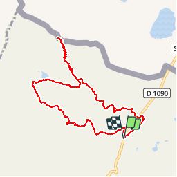
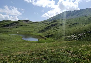
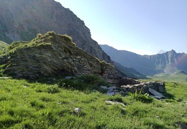
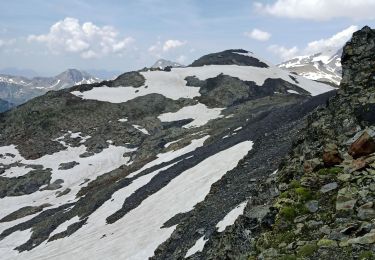
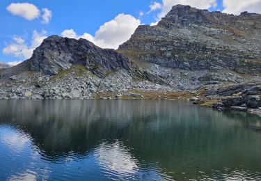
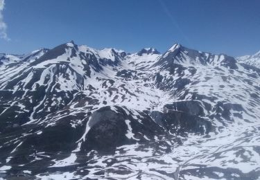
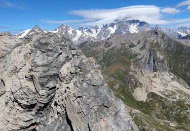
Ruta Senderismo de 10,2 km a descubrir en Auvergne-Rhône-Alpes, Saboya, Séez. Esta ruta ha sido propuesta por reneperrin.
Descripción
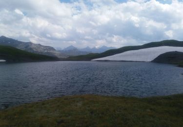
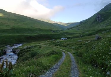
boucle au départ de la cabane des douaniers, sommet de Lancera lette, retour par le lac sans fond et le ruisseau
Localización
País:
France
Región :
Auvergne-Rhône-Alpes
Departamento/provincia :
Saboya
Municipio :
Séez
Localidad:
Unknown
Salida:(Dec)
Salida:(UTM)
334281 ; 5059370 (32T) N.
Comentarios
Excursiones cerca
![Excursión Senderismo Séez - hospice petit saint Bernard . lac dans fond . la parciere . hospice - Photo](https://media.geolcdn.com/t/375/260/cb23f3b1-848c-4f41-9bcb-bf02580d2bd3.jpg&format=jpg&maxdim=2)
![Senderismo Senderismo](https://static1.geolcdn.com/sitytour/trail-icons/101.png)
hospice petit saint Bernard . lac dans fond . la parciere . hospice
Senderismo
Muy fácil
(1)
Séez,
Auvergne-Rhône-Alpes,
Saboya,
France
![](/images/other/stat-length.png)
8,9 km | 13,7 km-effort
4h 16min
![](https://static1.geolcdn.com/siteimages/upload/files/16400158638029165_repeat_loop_refresh_sync_direction_icon.png)
Sí
![Excursión Senderismo Bourg-Saint-Maurice - col des Rousses - Photo](https://media.geolcdn.com/t/375/260/af69e770-c920-434a-a244-b14f3d62edb0.jpg&format=jpg&maxdim=2)
![Senderismo Senderismo](https://static1.geolcdn.com/sitytour/trail-icons/101.png)
col des Rousses
Senderismo
Medio
Bourg-Saint-Maurice,
Auvergne-Rhône-Alpes,
Saboya,
France
![](/images/other/stat-length.png)
10,5 km | 22 km-effort
4h 37min
![](https://static1.geolcdn.com/siteimages/upload/files/16400158638029165_repeat_loop_refresh_sync_direction_icon.png)
Sí
![Excursión Senderismo Bourg-Saint-Maurice - col des Ouillons, pointe 2695 et les grandes aiguilles - Photo](https://media.geolcdn.com/t/375/260/c558e85b-222b-48ae-b68f-d58c96ead386.jpg&format=jpg&maxdim=2)
![Senderismo Senderismo](https://static1.geolcdn.com/sitytour/trail-icons/101.png)
col des Ouillons, pointe 2695 et les grandes aiguilles
Senderismo
Difícil
Bourg-Saint-Maurice,
Auvergne-Rhône-Alpes,
Saboya,
France
![](/images/other/stat-length.png)
14,6 km | 30 km-effort
5h 13min
![](https://static1.geolcdn.com/siteimages/upload/files/16400158638029165_repeat_loop_refresh_sync_direction_icon.png)
Sí
![Excursión Senderismo Bourg-Saint-Maurice - col du Breuil et tentative de la pointe de l'Ouillon - Photo](https://media.geolcdn.com/t/375/260/aadc0a03-d638-48fc-8b46-3fd365012c7b.jpg&format=jpg&maxdim=2)
![Senderismo Senderismo](https://static1.geolcdn.com/sitytour/trail-icons/101.png)
col du Breuil et tentative de la pointe de l'Ouillon
Senderismo
Difícil
Bourg-Saint-Maurice,
Auvergne-Rhône-Alpes,
Saboya,
France
![](/images/other/stat-length.png)
10,3 km | 23 km-effort
4h 10min
![](https://static1.geolcdn.com/siteimages/upload/files/16400158638029165_repeat_loop_refresh_sync_direction_icon.png)
Sí
![Excursión Senderismo Bourg-Saint-Maurice - Le Miravidi et presque l'aiguille de Veis - Photo](https://media.geolcdn.com/t/375/260/492b54a4-3f98-46f8-a6c7-a59e4c43b79b.jpg&format=jpg&maxdim=2)
![Senderismo Senderismo](https://static1.geolcdn.com/sitytour/trail-icons/101.png)
Le Miravidi et presque l'aiguille de Veis
Senderismo
Medio
Bourg-Saint-Maurice,
Auvergne-Rhône-Alpes,
Saboya,
France
![](/images/other/stat-length.png)
12,4 km | 26 km-effort
6h 23min
![](https://static1.geolcdn.com/siteimages/upload/files/16400158638029165_repeat_loop_refresh_sync_direction_icon.png)
No
![Excursión Senderismo Montvalezan - passage de la Louie blanche et lac du retour - Photo](https://media.geolcdn.com/t/375/260/473f4e21-59c1-4ed2-ae81-88697aa95ac7.jpg&format=jpg&maxdim=2)
![Senderismo Senderismo](https://static1.geolcdn.com/sitytour/trail-icons/101.png)
passage de la Louie blanche et lac du retour
Senderismo
Difícil
Montvalezan,
Auvergne-Rhône-Alpes,
Saboya,
France
![](/images/other/stat-length.png)
13,3 km | 25 km-effort
6h 3min
![](https://static1.geolcdn.com/siteimages/upload/files/16400158638029165_repeat_loop_refresh_sync_direction_icon.png)
Sí
![Excursión Senderismo Séez - Lancebranlette avec retour par le Lac sans Fond - Photo](https://media.geolcdn.com/t/375/260/ext.jpg?maxdim=2&url=https%3A%2F%2Fstatic1.geolcdn.com%2Fsiteimages%2Fupload%2Ffiles%2F1553511878bg_sport_marche.png)
![Senderismo Senderismo](https://static1.geolcdn.com/sitytour/trail-icons/101.png)
Lancebranlette avec retour par le Lac sans Fond
Senderismo
Difícil
(1)
Séez,
Auvergne-Rhône-Alpes,
Saboya,
France
![](/images/other/stat-length.png)
9,5 km | 21 km-effort
4h 40min
![](https://static1.geolcdn.com/siteimages/upload/files/16400158638029165_repeat_loop_refresh_sync_direction_icon.png)
Sí
![Excursión Esquí de fondo Séez - col du Belvédère, le Valezan - Photo](https://media.geolcdn.com/t/375/260/d916e824-8a72-4541-a21a-b355921c434a.jpg&format=jpg&maxdim=2)
![Esquí de fondo Esquí de fondo](https://static1.geolcdn.com/sitytour/trail-icons/503.png)
col du Belvédère, le Valezan
Esquí de fondo
Fácil
Séez,
Auvergne-Rhône-Alpes,
Saboya,
France
![](/images/other/stat-length.png)
16,7 km | 33 km-effort
7h 49min
![](https://static1.geolcdn.com/siteimages/upload/files/16400158638029165_repeat_loop_refresh_sync_direction_icon.png)
Sí
![Excursión Senderismo Séez - lancebranlette et le lac sans fond - Photo](https://media.geolcdn.com/t/375/260/7ff96455-e075-478f-b097-5159a70e10f9.jpg&format=jpg&maxdim=2)
![Senderismo Senderismo](https://static1.geolcdn.com/sitytour/trail-icons/101.png)
lancebranlette et le lac sans fond
Senderismo
Medio
Séez,
Auvergne-Rhône-Alpes,
Saboya,
France
![](/images/other/stat-length.png)
10,3 km | 21 km-effort
5h 27min
![](https://static1.geolcdn.com/siteimages/upload/files/16400158638029165_repeat_loop_refresh_sync_direction_icon.png)
Sí