![](/images/other/stat-length.png)
![Excursión Senderismo Saint-Étienne-de-Tinée - circuit de Baudric, trou des Corneilles - Photo](https://media.geolcdn.com/t/1900/400/ext.pjpeg?maxdim=2&url=https%3A%2F%2Fservices.sitytrail.com%2FGeolivesWS%2FDownloadMedia.ashx%3FTrailID%3D797325%26Media%3Dfix__20170727134353.jpg)
circuit de Baudric, trou des Corneilles
fhascoet
Usuario
![Longitud](/images/other/stat-length.png)
![Altitud máxima](https://static1.geolcdn.com/siteimages/upload/files/1508320355ic_sort_altitude_max_24dp.png)
![Desnivel positivo](https://static1.geolcdn.com/siteimages/upload/files/1508320355ic_sort_den_pos_24dp.png)
![Km-Effort](/images/other/stat-length.png)
![Altitud mínima](https://static1.geolcdn.com/siteimages/upload/files/1508320355ic_sort_altitude_min_24dp.png)
![Desnivel negativo](https://static1.geolcdn.com/siteimages/upload/files/1508320355ic_sort_den_neg_24dp.png)
![Boucle](https://static1.geolcdn.com/siteimages/upload/files/16400158638029165_repeat_loop_refresh_sync_direction_icon.png)
![Senderismo](https://static1.geolcdn.com/sitytour/trail-icons/101.png)
3h28
Dificultad : Medio
![Escanee este código QR para abrir la excursión en la aplicación SityTrail](https://capi.geolives.com/qq0zvz2zws4bq2lad0pu/sitytour/trails/797325/qr.png?size=200)
Aplicación GPS de excursión GRATIS
A propósito
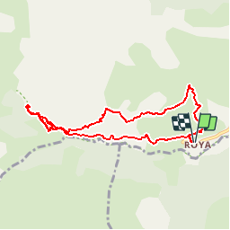
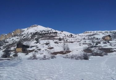
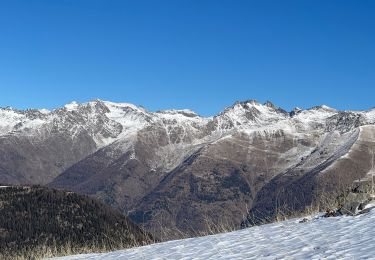
Ruta Senderismo de 9 km a descubrir en Provenza-Alpes-Costa Azul, Alpes Marítimos, Saint-Étienne-de-Tinée. Esta ruta ha sido propuesta por fhascoet.
Descripción
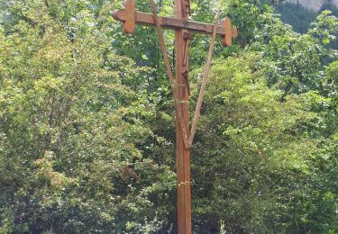
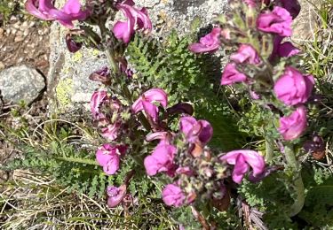
Belle promenade en Balcon puis montée en passant parle trou des Corneilles ( dessus du Canyon) jusqu’à un accès au torrent.
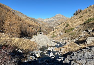
Après retour au pont, remontée du torrent pour voir l’impressionnante sortie du canyon.
Localización
Comentarios
Excursiones cerca
![Excursión Senderismo Saint-Étienne-de-Tinée - Réel Roya Col de Crousette Stèle Valette Petit Mounier et Mounier - Photo](https://media.geolcdn.com/t/375/260/b5c86927-6c55-4c7f-afae-58ada10c53b3.jpg&format=jpg&maxdim=2)
![Senderismo Senderismo](https://static1.geolcdn.com/sitytour/trail-icons/101.png)
Senderismo
![](/images/other/stat-length.png)
![](https://static1.geolcdn.com/siteimages/upload/files/16400158638029165_repeat_loop_refresh_sync_direction_icon.png)
![Excursión A pie Saint-Étienne-de-Tinée - Cime de la Bercha - Photo](https://media.geolcdn.com/t/375/260/06e4d46f-e317-406d-bd2c-01041e541c38.jpeg&format=jpg&maxdim=2)
![A pie A pie](https://static1.geolcdn.com/sitytour/trail-icons/100.png)
A pie
![](/images/other/stat-length.png)
![](https://static1.geolcdn.com/siteimages/upload/files/16400158638029165_repeat_loop_refresh_sync_direction_icon.png)
![Excursión Esquí de fondo Saint-Étienne-de-Tinée - Mont Triboulet et Mont Rion - Photo](https://media.geolcdn.com/t/375/260/628b9303-05b3-4c82-bf08-aa61a07e7015.jpg&format=jpg&maxdim=2)
![Esquí de fondo Esquí de fondo](https://static1.geolcdn.com/sitytour/trail-icons/503.png)
Esquí de fondo
![](/images/other/stat-length.png)
![](https://static1.geolcdn.com/siteimages/upload/files/16400158638029165_repeat_loop_refresh_sync_direction_icon.png)
![Excursión Esquí de fondo Saint-Étienne-de-Tinée - Las Donnas et baisse du Colombier - Photo](https://media.geolcdn.com/t/375/260/0cedeff1-332d-460c-af06-a42d22a26fa2.jpg&format=jpg&maxdim=2)
![Esquí de fondo Esquí de fondo](https://static1.geolcdn.com/sitytour/trail-icons/503.png)
Esquí de fondo
![](/images/other/stat-length.png)
![](https://static1.geolcdn.com/siteimages/upload/files/16400158638029165_repeat_loop_refresh_sync_direction_icon.png)
![Excursión Raquetas de nieve Saint-Étienne-de-Tinée - Cabane Vieille - Photo](https://media.geolcdn.com/t/375/260/d08ad509-8448-4a00-bc95-11334e53fd24.jpg&format=jpg&maxdim=2)
![Raquetas de nieve Raquetas de nieve](https://static1.geolcdn.com/sitytour/trail-icons/504.png)
Raquetas de nieve
![](/images/other/stat-length.png)
![](https://static1.geolcdn.com/siteimages/upload/files/16400158638029165_repeat_loop_refresh_sync_direction_icon.png)
![Excursión Senderismo Saint-Étienne-de-Tinée - Le Mounier - Photo](https://media.geolcdn.com/t/375/260/6d3039c6-e5bd-4a5c-b5ca-417ffa1a190a.jpg&format=jpg&maxdim=2)
![Senderismo Senderismo](https://static1.geolcdn.com/sitytour/trail-icons/101.png)
Senderismo
![](/images/other/stat-length.png)
![](https://static1.geolcdn.com/siteimages/upload/files/16400158638029165_repeat_loop_refresh_sync_direction_icon.png)
![Excursión Senderismo Saint-Étienne-de-Tinée - Le Corborant - Photo](https://media.geolcdn.com/t/375/260/4e6a72e4-8dfa-499a-bed5-882b283528e3.jpeg&format=jpg&maxdim=2)
![Senderismo Senderismo](https://static1.geolcdn.com/sitytour/trail-icons/101.png)
Senderismo
![](/images/other/stat-length.png)
![](https://static1.geolcdn.com/siteimages/upload/files/16400158638029165_repeat_loop_refresh_sync_direction_icon.png)
![Excursión Senderismo Saint-Étienne-de-Tinée - De Roya au Col de Blainon, baisse herisson - Photo](https://media.geolcdn.com/t/375/260/f3ff390a-3102-4c2f-baae-0abdbac6b210.jpg&format=jpg&maxdim=2)
![Senderismo Senderismo](https://static1.geolcdn.com/sitytour/trail-icons/101.png)
Senderismo
![](/images/other/stat-length.png)
![](https://static1.geolcdn.com/siteimages/upload/files/16400158638029165_repeat_loop_refresh_sync_direction_icon.png)
![Excursión sport Saint-Étienne-de-Tinée - Tête de l autaret Lagos colla longa - Photo](https://media.geolcdn.com/t/375/260/0f54380f-0cc0-41e9-83d3-976012bf1985.jpg&format=jpg&maxdim=2)
sport
![](/images/other/stat-length.png)
![](https://static1.geolcdn.com/siteimages/upload/files/16400158638029165_repeat_loop_refresh_sync_direction_icon.png)