![](/images/other/stat-length.png)
![Excursión Bicicleta Lommel - De Kempense kanalen en zandwinningen. - Photo](https://media.geolcdn.com/t/1900/400/ext.pjpeg?maxdim=2&url=https%3A%2F%2Fservices.sitytrail.com%2FGeolivesWS%2FDownloadMedia.ashx%3FTrailID%3D793767%26Media%3Dfix__20170721162641.jpg)
De Kempense kanalen en zandwinningen.
karawatsj
Usuario
![Longitud](/images/other/stat-length.png)
![Altitud máxima](https://static1.geolcdn.com/siteimages/upload/files/1508320355ic_sort_altitude_max_24dp.png)
![Desnivel positivo](https://static1.geolcdn.com/siteimages/upload/files/1508320355ic_sort_den_pos_24dp.png)
![Km-Effort](/images/other/stat-length.png)
![Altitud mínima](https://static1.geolcdn.com/siteimages/upload/files/1508320355ic_sort_altitude_min_24dp.png)
![Desnivel negativo](https://static1.geolcdn.com/siteimages/upload/files/1508320355ic_sort_den_neg_24dp.png)
![Boucle](https://static1.geolcdn.com/siteimages/upload/files/16400158638029165_repeat_loop_refresh_sync_direction_icon.png)
![Bicicleta](https://static1.geolcdn.com/sitytour/trail-icons/200.png)
4h40
Dificultad : Fácil
![Escanee este código QR para abrir la excursión en la aplicación SityTrail](https://capi.geolives.com/qq0zvz2zws4bq2lad0pu/sitytour/trails/793767/qr.png?size=200)
Aplicación GPS de excursión GRATIS
A propósito
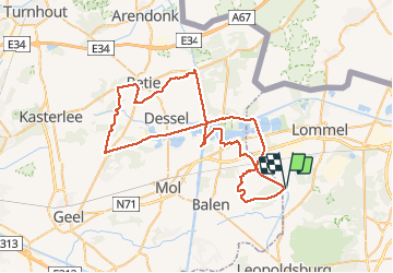
Ruta Bicicleta de 65 km a descubrir en Flandes, Limburgo, Lommel. Esta ruta ha sido propuesta por karawatsj.
Descripción
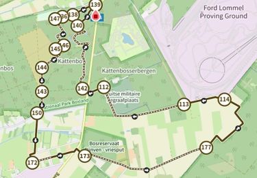
We volgen het knooppuntennetwerk www.fietsnet.be De route start ongeveer aan knooppunt 60 aan de brug van Gelderhorsten over het kanaal van Beverlo. We volgen vervolgens knpnt. 266/268/267/260/75/74/12/72/7/42/92/93/94/95/96/73/50/14/10/58/59/60.
Zeer mooie route langs de oudste kanalen van België.
http://nl.wikipedia.org/wiki/Kempische_kanalen
Heel mooi en rustig, met tal van drink- en eetgelegenheden.
Ook kom je langs:
- Blauwe Kei.
- Vele sluizenkomplexen op het kanaal Bocholt-Herentals en het kanaal Dessel-Schoten.
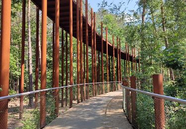
- uitkijktoren aan kruising van kanalen.
- De Pannenkoekenboot
- Provinciaal Domein Prinsenpark.
- Boerentang.
- Aerodroom De Keiheuvel.
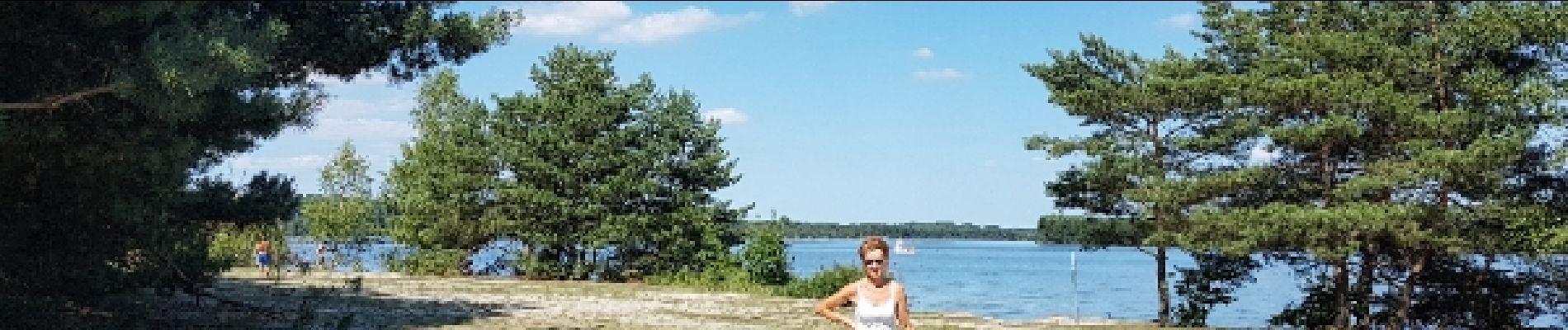
- Zilvermeer
- Kanaal Kwaadmechelen-Dessel
- Natuurgebied De Most
Andere interessante vertrekmogelijkheden zijn (ca 6km extra):
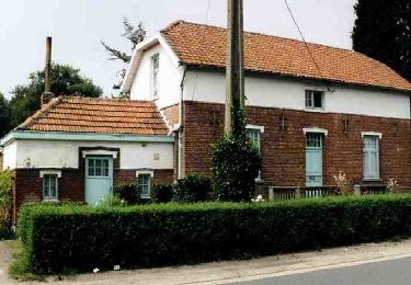
- Hof ten Vrede aan Het Duis Militair Kerkhof of
- het restaurant De Waterkant te Kerkhoven
Localización
Comentarios
Excursiones cerca
![Excursión Senderismo Hechtel-Eksel - Promenade vers la piste dans les arbres - Photo](https://media.geolcdn.com/t/375/260/d3e0d7d1-5d05-4822-929e-083da86eeeb1.jpg&format=jpg&maxdim=2)
![Senderismo Senderismo](https://static1.geolcdn.com/sitytour/trail-icons/101.png)
Senderismo
![](/images/other/stat-length.png)
![](https://static1.geolcdn.com/siteimages/upload/files/16400158638029165_repeat_loop_refresh_sync_direction_icon.png)
![Excursión A pie Lommel - Kerkhoven Oranje bol - Photo](https://media.geolcdn.com/t/375/260/ba24e6d5-e13e-41c6-84b4-b97f206df1d2.jpeg&format=jpg&maxdim=2)
![A pie A pie](https://static1.geolcdn.com/sitytour/trail-icons/100.png)
A pie
![](/images/other/stat-length.png)
![](https://static1.geolcdn.com/siteimages/upload/files/16400158638029165_repeat_loop_refresh_sync_direction_icon.png)
![Excursión A pie Lommel - Kattenbos Oranje bol - Photo](https://media.geolcdn.com/t/375/260/25d19ba3-ac8f-4423-8a3a-4c96d09c79ad.jpeg&format=jpg&maxdim=2)
![A pie A pie](https://static1.geolcdn.com/sitytour/trail-icons/100.png)
A pie
![](/images/other/stat-length.png)
![](https://static1.geolcdn.com/siteimages/upload/files/16400158638029165_repeat_loop_refresh_sync_direction_icon.png)
![Excursión A pie Hechtel-Eksel - Pijnven Rode driehoek - Photo](https://media.geolcdn.com/t/375/260/e430025e-18dc-454c-a365-4a137942eca1.jpeg&format=jpg&maxdim=2)
![A pie A pie](https://static1.geolcdn.com/sitytour/trail-icons/100.png)
A pie
![](/images/other/stat-length.png)
![](https://static1.geolcdn.com/siteimages/upload/files/16400158638029165_repeat_loop_refresh_sync_direction_icon.png)
![Excursión A pie Hechtel-Eksel - Pijnven Oranje bol - Photo](https://media.geolcdn.com/t/375/260/e430025e-18dc-454c-a365-4a137942eca1.jpeg&format=jpg&maxdim=2)
![A pie A pie](https://static1.geolcdn.com/sitytour/trail-icons/100.png)
A pie
![](/images/other/stat-length.png)
![](https://static1.geolcdn.com/siteimages/upload/files/16400158638029165_repeat_loop_refresh_sync_direction_icon.png)
![Excursión Senderismo Hechtel-Eksel - Eksel het Pijnven Hechtel-Eksel - 8 km RT - Photo](https://media.geolcdn.com/t/375/260/ext.jpg?maxdim=2&url=https%3A%2F%2Fstatic1.geolcdn.com%2Fsiteimages%2Fupload%2Ffiles%2F1553511878bg_sport_marche.png)
![Senderismo Senderismo](https://static1.geolcdn.com/sitytour/trail-icons/101.png)
Senderismo
![](/images/other/stat-length.png)
![](https://static1.geolcdn.com/siteimages/upload/files/16400158638029165_repeat_loop_refresh_sync_direction_icon.png)
![Excursión Senderismo Lommel - 2024-02-22_20h02m45_betoverend-bosland - Photo](https://media.geolcdn.com/t/375/260/6be4c4ba-9134-4fc5-82b5-e31e215c105b.jpg&format=jpg&maxdim=2)
![Senderismo Senderismo](https://static1.geolcdn.com/sitytour/trail-icons/101.png)
Senderismo
![](/images/other/stat-length.png)
![](https://static1.geolcdn.com/siteimages/upload/files/16400158638029165_repeat_loop_refresh_sync_direction_icon.png)
![Excursión Senderismo Lommel - A la découverte de Lommel - Photo](https://media.geolcdn.com/t/375/260/2368d35a-45d7-4a61-8709-fc2605b12449.jpg&format=jpg&maxdim=2)
![Senderismo Senderismo](https://static1.geolcdn.com/sitytour/trail-icons/101.png)
Senderismo
![](/images/other/stat-length.png)
![](https://static1.geolcdn.com/siteimages/upload/files/16400158638029165_repeat_loop_refresh_sync_direction_icon.png)
![Excursión A pie Balen - Keiheuvelwandeling - Photo](https://media.geolcdn.com/t/375/260/ea987881-3e8c-4e28-b291-d48e23e3d378.jpeg&format=jpg&maxdim=2)
![A pie A pie](https://static1.geolcdn.com/sitytour/trail-icons/100.png)
A pie
![](/images/other/stat-length.png)
![](https://static1.geolcdn.com/siteimages/upload/files/16400158638029165_repeat_loop_refresh_sync_direction_icon.png)