![](/images/other/stat-length.png)
![Excursión Senderismo Vallouise-Pelvoux - REFUGE DES ECRINS.01 10 13 - Photo](https://media.geolcdn.com/t/1900/400/ext.pjpeg?maxdim=2&url=https%3A%2F%2Fstatic1.geolcdn.com%2Fsiteimages%2Fupload%2Ffiles%2F1553511878bg_sport_marche.png)
REFUGE DES ECRINS.01 10 13
Dervalmarc
Usuario
![Longitud](/images/other/stat-length.png)
![Altitud máxima](https://static1.geolcdn.com/siteimages/upload/files/1508320355ic_sort_altitude_max_24dp.png)
![Desnivel positivo](https://static1.geolcdn.com/siteimages/upload/files/1508320355ic_sort_den_pos_24dp.png)
![Km-Effort](/images/other/stat-length.png)
![Altitud mínima](https://static1.geolcdn.com/siteimages/upload/files/1508320355ic_sort_altitude_min_24dp.png)
![Desnivel negativo](https://static1.geolcdn.com/siteimages/upload/files/1508320355ic_sort_den_neg_24dp.png)
![Boucle](https://static1.geolcdn.com/siteimages/upload/files/16400158638029165_repeat_loop_refresh_sync_direction_icon.png)
![Senderismo](https://static1.geolcdn.com/sitytour/trail-icons/101.png)
4h45
Dificultad : Difícil
![Escanee este código QR para abrir la excursión en la aplicación SityTrail](https://capi.geolives.com/qq0zvz2zws4bq2lad0pu/sitytour/trails/762051/qr.png?size=200)
Aplicación GPS de excursión GRATIS
A propósito
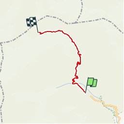
Ruta Senderismo de 7,2 km a descubrir en Provenza-Alpes-Costa Azul, Altos Alpes, Vallouise-Pelvoux. Esta ruta ha sido propuesta por Dervalmarc.
Descripción
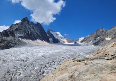
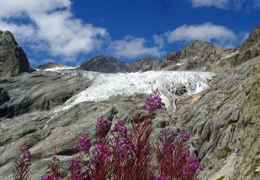
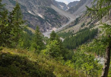
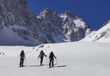
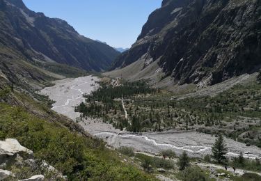
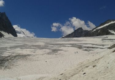
Le refuge des Écrins, appelé aussi refuge Caron est situé sur la commune de Pelvoux, dans le Briançonnais, au cœur du massif des Écrins. Il surplombe le glacier Blanc. Il offre un beau panorama notamment sur la Barre des Écrins.Un grand refuge emblématique situé à 100m environ au dessus du glacier dans un cadre exceptionnel. En fait le sentier est une successions de marque a suivre, un peu comme sur les étapes alpines du GR20. Compter huit a dix heures pour l' aller retour.
Localización
Comentarios
Excursiones cerca
![Excursión Senderismo Vallouise-Pelvoux - traversé du pelvoux - Photo](https://media.geolcdn.com/t/375/260/ext.jpg?maxdim=2&url=https%3A%2F%2Fservices.sitytrail.com%2FGeolivesWS%2FDownloadMedia.ashx%3FTrailID%3D593533%26Media%3Dfix__20160628143021.jpg)
![Senderismo Senderismo](https://static1.geolcdn.com/sitytour/trail-icons/101.png)
Senderismo
![](/images/other/stat-length.png)
![](https://static1.geolcdn.com/siteimages/upload/files/16400158638029165_repeat_loop_refresh_sync_direction_icon.png)
![Excursión Senderismo Vallouise-Pelvoux - le refuge glacier blanc et le point de vue sur la barre - Photo](https://media.geolcdn.com/t/375/260/ee7879b1-8037-4c55-8194-cccf54ddc846.jpg&format=jpg&maxdim=2)
![Senderismo Senderismo](https://static1.geolcdn.com/sitytour/trail-icons/101.png)
Senderismo
![](/images/other/stat-length.png)
![](https://static1.geolcdn.com/siteimages/upload/files/16400158638029165_repeat_loop_refresh_sync_direction_icon.png)
![Senderismo Senderismo](https://static1.geolcdn.com/sitytour/trail-icons/101.png)
Senderismo
![](/images/other/stat-length.png)
![](https://static1.geolcdn.com/siteimages/upload/files/16400158638029165_repeat_loop_refresh_sync_direction_icon.png)
![Excursión Senderismo Vallouise-Pelvoux - Cascade de Clapouse - Photo](https://media.geolcdn.com/t/375/260/286a2188-66ce-4041-a719-0c298b9ee070.jpg&format=jpg&maxdim=2)
![Senderismo Senderismo](https://static1.geolcdn.com/sitytour/trail-icons/101.png)
Senderismo
![](/images/other/stat-length.png)
![](https://static1.geolcdn.com/siteimages/upload/files/16400158638029165_repeat_loop_refresh_sync_direction_icon.png)
![Excursión Esquí de fondo Vallouise-Pelvoux - Le glacier noir - Photo](https://media.geolcdn.com/t/375/260/9edc57a6-e106-44ef-aa2a-0b82165dbf2c.jpg&format=jpg&maxdim=2)
![Esquí de fondo Esquí de fondo](https://static1.geolcdn.com/sitytour/trail-icons/503.png)
Esquí de fondo
![](/images/other/stat-length.png)
![](https://static1.geolcdn.com/siteimages/upload/files/16400158638029165_repeat_loop_refresh_sync_direction_icon.png)
![Excursión Senderismo Vallouise-Pelvoux - 05-pre-Mme-Carle-glacier-noir-8km-600m-aout21 - Photo](https://media.geolcdn.com/t/375/260/f2b460db-8baa-455c-9aa4-9129d164ea68.jpg&format=jpg&maxdim=2)
![Senderismo Senderismo](https://static1.geolcdn.com/sitytour/trail-icons/101.png)
Senderismo
![](/images/other/stat-length.png)
![](https://static1.geolcdn.com/siteimages/upload/files/16400158638029165_repeat_loop_refresh_sync_direction_icon.png)
![Excursión Senderismo Vallouise-Pelvoux - Source Puiseux - Photo](https://media.geolcdn.com/t/375/260/dabe64c5-d5a8-4a8f-93af-5c262924c5df.jpg&format=jpg&maxdim=2)
![Senderismo Senderismo](https://static1.geolcdn.com/sitytour/trail-icons/101.png)
Senderismo
![](/images/other/stat-length.png)
![](https://static1.geolcdn.com/siteimages/upload/files/16400158638029165_repeat_loop_refresh_sync_direction_icon.png)
![Excursión Senderismo Vallouise-Pelvoux - Le Glacier Blanc - Pré Madame Carle - Photo](https://media.geolcdn.com/t/375/260/dec81677-af0a-430c-a892-df5e1d841b58.jpg&format=jpg&maxdim=2)
![Senderismo Senderismo](https://static1.geolcdn.com/sitytour/trail-icons/101.png)
Senderismo
![](/images/other/stat-length.png)
![](https://static1.geolcdn.com/siteimages/upload/files/16400158638029165_repeat_loop_refresh_sync_direction_icon.png)
![Excursión Senderismo Vallouise-Pelvoux - Les Écrins jour 2 - Photo](https://media.geolcdn.com/t/375/260/ext.jpg?maxdim=2&url=https%3A%2F%2Fservices.sitytrail.com%2FGeolivesWS%2FDownloadMedia.ashx%3FTrailID%3D1006317%26Media%3Dfix__20180717140759.jpg)
![Senderismo Senderismo](https://static1.geolcdn.com/sitytour/trail-icons/101.png)
Senderismo
![](/images/other/stat-length.png)
![](https://static1.geolcdn.com/siteimages/upload/files/16400158638029165_repeat_loop_refresh_sync_direction_icon.png)